Spring Garden, Philadelphia facts for kids
Quick facts for kids |
|
|
Spring Garden District
|
|

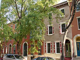
The Spring Garden section of Philadelphia in August 2010
|
|
| Location | Roughly centered on Spring Garden Street and bounded by Fairmount Avenue, Broad Street, the Schuylkill River, and Vine Street, Philadelphia, Pennsylvania |
|---|---|
| Architect | Multiple |
| Architectural style | Late 19th And 20th century Revivalism, Late Victorian |
| NRHP reference No. | 78002455 |
| Added to NRHP | December 21, 1978 |
Spring Garden is a cool neighborhood in the middle of Philadelphia, Pennsylvania. It's right next to Center City on its north side. Spring Garden is a place with many different kinds of homes and important cultural spots.
In the northern part of the neighborhood, most homes are brick or brownstone houses with three stories. They were built in the mid-to-late 1800s. You can see different styles like Italianate, Second Empire, Queen Anne, and Venetian Gothic. Some streets, like Green Street, have small gardens in front of the houses. These gardens are often a bit raised.
South of Spring Garden Street, you'll find taller apartment buildings built in the 1900s. This area also has famous museums like the Rodin Museum, the Free Library of Philadelphia, and the Barnes Foundation. Before Philadelphia became one big city in 1854, Spring Garden was its own district in Philadelphia County.
Contents
Where is Spring Garden?
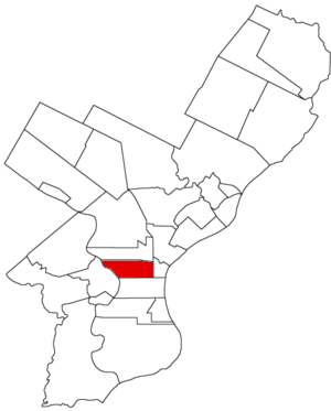
Experts describe Spring Garden as being north of Benjamin Franklin Parkway up to Fairmount Avenue. It stretches from Broad Street to the Schuylkill River. Some also agree that Vine Street is another important border.
The Spring Garden Civic Association focuses on the northern part of this area. They say their part is between Spring Garden Street and Fairmount Avenue. It also lies between Broad Street and Pennsylvania Avenue/Fairmount Park.
A smaller area called Baldwin Park is located between Spring Garden Street and Vine Street. It also stretches from Broad Street to the Schuylkill River. This area is named after Matthias Baldwin Park, which is right in the middle of it. Spring Garden Street is the main road that runs east to west through the neighborhood.
People of Spring Garden
| Historical population | ||
|---|---|---|
| Year | Pop. | ±% |
| 1820 | 3,498 | — |
| 1830 | 11,140 | +218.5% |
| 1840 | 27,849 | +150.0% |
| 1850 | 58,894 | +111.5% |
Spring Garden is part of the 19130 ZIP Code. This ZIP code also includes the neighborhoods of Fairmount and Francisville.
In the year 2000, about 22,252 people lived in the 19130 ZIP code. The population was 60% white, 30% African American, 3% Asian, and 7% Hispanic.
Ten years later, in 2010, the population grew by 10% to 24,870 people. The racial makeup changed a bit too. It was 68.1% white, 21.4% black, and 5.6% Asian.
Before Spring Garden became part of Philadelphia in 1854, it was a very large city on its own. In the 1850 Census, Spring Garden was the ninth largest city in the United States!
History of Spring Garden

Spring Garden first appeared on a map in 1796 as a small settlement. It was located between Vine Street and Buttonwood Lane. It also reached as far west as Ridge Road.
This area was originally part of Northern Liberties. This was a township north of the city of Philadelphia. It was once part of a large farm called Spingettsbury Farm, owned by William Penn.
In the late 1700s, the farm was divided into two estates: "Bush Hill" and "The Hills." In the early 1800s, these estates were split into smaller pieces. From 1850 to 1876, houses were built following the city's street plan.
The name "Spring Garden" is very old. It was used many decades before Philadelphia became one big city in 1854. At that time, it was known as the Spring Garden District of Philadelphia County. Some records show the name being used as early as 1808 or 1813.
The district officially became "the Commissioners and Inhabitants of the district of Spring Garden" on March 22, 1813. Its first borders were Vine Street to the south and Hickory Lane (now Fairmount Avenue) to the north. It stretched from Broad Street in the west to Sixth Street in the east.
On March 21, 1827, the district grew much larger. It added more land from Penn Township. This made Spring Garden more than twice its original size. By the time it joined Philadelphia in 1854, the district was about 1100 acres (4.5 square kilometers).
York Avenue was a diagonal street that used to run from Spring Garden to Fifth Street. In the mid-1800s, it was a major route for people living in Spring Garden. They used it to get to work in what was then the main business area of Philadelphia.
When Spring Garden joined Philadelphia in 1854, it was one of the ten biggest cities in the United States.
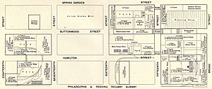
The neighborhood was once home to big factories. A large part of the area was covered by the Baldwin Locomotive Works, which made trains. Other companies that made tools, like Bement, Miles & Co., were located where the Barnes Foundation museum is today.
Getting Around Spring Garden
By Car
Spring Garden Street is the main road that runs east and west through the neighborhood. Broad Street forms the eastern border, running north and south. Vine Street is on the south side and has an entrance to Interstate 676. On the west, the neighborhood is bordered by the Benjamin Franklin Parkway and Pennsylvania Avenue.
Public Transportation
SEPTA, the Southeastern Pennsylvania Transportation Authority, provides several ways to get around Spring Garden. Even though the neighborhood has a rich railway history, most of its old train tracks are gone.
Many bus routes and a subway route connect Spring Garden to Center City and other parts of Philadelphia.
Broad Street Subway
On the east side of the neighborhood, the subway connects Spring Garden to places like Temple University in North Philadelphia. It also goes to City Hall, Walnut Street, and the Sports Complex. The Spring Garden station was updated in 2011. It is located at Broad Street and Spring Garden Street.
Bus Routes
- Bus Route 33: This bus travels south on 19th Street and then east along Market Street to Penn's Landing. It returns west on John F. Kennedy Boulevard and north on 20th Street.
- Bus Route 2: This bus goes south on 17th Street through Spring Garden and Center City to South Philadelphia. It returns north on 16th Street.
- Bus Route 7: This route runs south along 23rd Street. It turns onto Pennsylvania Avenue and then heads south into Center City.
- Bus Route 48: This bus also runs south along 23rd Street. It turns onto Pennsylvania Avenue and then goes south into Center City. It heads east on Market Street. When leaving Center City, it goes west on Arch Street and then north on 22nd Street.
- Bus Route 32: This bus travels southeast along Pennsylvania Avenue. It goes east on Hamilton Street and then south into Center City. It heads east on Market Street and then south on Broad Street. When leaving Center City, it goes north on Broad Street and then east on John F. Kennedy Boulevard to 18th Street.
- Bus Route 43: This bus runs east and west along Spring Garden Street. Eastbound, it goes to Front Street and Delaware Avenue. Westbound, it crosses the Schuylkill River to Lancaster Avenue.
Schools in Spring Garden
Public Schools
Spring Garden is part of the School District of Philadelphia. Most elementary school children in the area attend Laura Wheeler Waring Elementary School. However, many also go to other schools like Albert M. Greenfield Elementary School.
Spring Garden is home to Benjamin Franklin High School and Franklin Learning Center. It also has one of the top public high schools in the city and state, the Julia R. Masterman School, located at 1699 Spring Garden Street. Students can also choose to attend other schools in Philadelphia through a special transfer program.
Private Schools
Spring Garden has private schools too. It is home to the J. W. Hallahan Catholic Girls High School. For boys, the Roman Catholic High School is just outside the neighborhood. Spring Garden also has St. Francis Xavier School, which is a Catholic school for younger students.
Churches in Spring Garden
Spring Garden has several churches. These include St. Andrew's Church, which is the only Lithuanian-Catholic church in the city. You can also find St. Francis Xavier Church, Olivet Covenant Presbyterian Church, Greater Canaan Church of God in Christ, United for Christ Ministries, and Enon Baptist Church.


