
St. John, North Dakota facts for kids
Quick facts for kids
Jeannotte’s Rule St. John, North Dakota
|
|
|---|---|
 |
|

Location of St. John, North Dakota
|
|
| Country | United States |
| State | North Dakota |
| County | Rolette |
| Founded | 1882 |
| Incorporated | 1903 |
| Area | |
| • Total | 0.44 sq mi (1.14 km2) |
| • Land | 0.44 sq mi (1.14 km2) |
| • Water | 0.00 sq mi (0.00 km2) |
| Elevation | 1,952 ft (595 m) |
| Population
(2020)
|
|
| • Total | 322 |
| • Estimate
(2022)
|
317 |
| • Density | 728.51/sq mi (281.46/km2) |
| Time zone | UTC-6 (Central (CST)) |
| • Summer (DST) | UTC-5 (CDT) |
| ZIP Code |
58369
|
| Area code(s) | 701 |
| FIPS code | 38-69980 |
| GNIS feature ID | 1036251 |
St. John or Saint John is a small city in Rolette County, North Dakota, United States. It's located very close to the Canadian border, near Manitoba. In 2020, about 322 people lived there.
Contents
History of St. John
St. John was first planned out in 1882. The town got its name from a parish in Quebec, Canada. This was the home area of a missionary who lived nearby.
The town officially became a city in 1903. A post office has been serving the community of St. John since 1882.
Geography and Location
St. John covers a total area of about 0.45 square miles (1.14 square kilometers). All of this area is land.
This city is known for being very close to the Canada–United States border. It's one of the towns in the U.S. that is closest to a "practical exclave" of the United States. This means it's near a piece of U.S. land that is almost completely surrounded by Canada.
Population and People
The population of St. John has changed over the years. Here's how many people have lived there during different census counts:
| Historical population | |||
|---|---|---|---|
| Census | Pop. | %± | |
| 1910 | 424 | — | |
| 1920 | 460 | 8.5% | |
| 1930 | 372 | −19.1% | |
| 1940 | 517 | 39.0% | |
| 1950 | 451 | −12.8% | |
| 1960 | 420 | −6.9% | |
| 1970 | 367 | −12.6% | |
| 1980 | 401 | 9.3% | |
| 1990 | 368 | −8.2% | |
| 2000 | 358 | −2.7% | |
| 2010 | 341 | −4.7% | |
| 2020 | 322 | −5.6% | |
| 2022 (est.) | 317 | −7.0% | |
| U.S. Decennial Census 2020 Census |
|||
What the 2010 Census Showed
In 2010, there were 341 people living in St. John. These people lived in 138 different homes. About 76 of these homes were families.
The city had about 758 people per square mile. There were 151 housing units in total.
The people living in St. John came from different backgrounds:
- 23.2% were White.
- 0.3% were African American.
- 66.0% were Native American.
- 1.2% were Asian.
- 9.4% were from two or more racial backgrounds.
- About 0.9% of the population identified as Hispanic or Latino.
Many homes (38.4%) had children under 18 living there. About 28.3% of homes were married couples. Some homes had a single parent, with 20.3% having a female head of household and 6.5% having a male head of household.
The average home had 2.47 people. The average family had 3.37 people.
The average age of people in the city was 30.4 years old.
- 30.5% of residents were under 18.
- 10.8% were between 18 and 24.
- 25.8% were between 25 and 44.
- 22% were between 45 and 64.
- 10.9% were 65 years or older.
The city had slightly more females (52.8%) than males (47.2%).
Education in St. John
Children in St. John attend schools within the St. John School District.
Images for kids
-
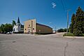
A view of St. John, North Dakota.
-
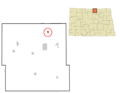
Map showing the location of St. John in Rolette County, North Dakota.
See also
 In Spanish: St. John (Dakota del Norte) para niños
