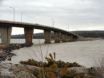
St. Joseph Channel facts for kids
Quick facts for kids St. Joseph Channel |
|
|---|---|
 |
|
|
Location in Ontario
|
|
| Country | Canada, United States |
| State | Michigan, Ontario |
| District | Algoma District, Chippewa County |
| Physical characteristics | |
| Main source | Lake George 46°20′21″N 84°06′31″W / 46.33917°N 84.10861°W |
| 2nd source | Middle Neebish Channel 46°19′16″N 84°08′33″W / 46.32111°N 84.14250°W |
| River mouth | North Channel 46°15′22″N 83°45′56″W / 46.25611°N 83.76556°W |
| Basin features | |
| River system | Great Lakes Basin |
The St. Joseph Channel is a narrow waterway, like a natural river, located in both Canada and the United States. It's part of the huge Great Lakes Basin, which is a large area of land where all the water drains into the Great Lakes. This channel connects several important water bodies, acting like a watery highway between them.
What is the St. Joseph Channel?
The St. Joseph Channel is a special type of waterway called a strait. A strait is a narrow passage of water that connects two larger bodies of water. This channel is found in Ontario, Canada, specifically in the Algoma District. It also stretches into Michigan, United States, in an area called Chippewa County.
Where Does It Connect?
This channel is like a busy intersection for water. It links the St. Marys River with the North Channel. The St. Marys River flows through two smaller passages:
- The Middle Neebish Channel, which is between Neebish Island and Sugar Island.
- Lake George, also known as the East Neebish Channel, which is between Sugar Island and the mainland of Ontario.
To the east, the St. Joseph Channel connects with the North Channel. This North Channel is located between St. Joseph Island and the Ontario mainland. To the southwest, it connects with the Munuscong Channel. This channel is found between Neebish Island and St. Joseph Island. All of these water bodies are part of Lake Huron, one of the five Great Lakes.
 | Percy Lavon Julian |
 | Katherine Johnson |
 | George Washington Carver |
 | Annie Easley |


