St. Lawrence, Pennsylvania facts for kids
Quick facts for kids
St. Lawrence, Pennsylvania
|
|
|---|---|

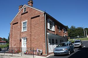
John F. Lutz Furniture Co. Carriage House
|
|

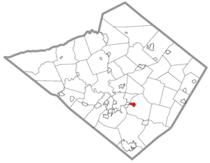
Location of St. Lawrence in Berks County, Pennsylvania.
|
|
| Country | United States |
| State | Pennsylvania |
| County | Berks |
| Area | |
| • Total | 0.90 sq mi (2.32 km2) |
| • Land | 0.90 sq mi (2.32 km2) |
| • Water | 0.00 sq mi (0.00 km2) |
| Elevation | 400 ft (100 m) |
| Population
(2020)
|
|
| • Total | 1,892 |
| • Density | 2,109.25/sq mi (814.81/km2) |
| Time zone | UTC-5 (EST) |
| • Summer (DST) | UTC-4 (EDT) |
| ZIP code |
19606
|
| Area code(s) | 610 and 484 |
| FIPS code | 42-67304 |
St. Lawrence is a small town, called a borough, located in Berks County, Pennsylvania, United States. In 2020, about 1,892 people lived there. St. Lawrence is just east of Mount Penn and Reading. Students in St. Lawrence attend schools in the Exeter Township School District.
Contents
History of St. Lawrence
The buildings of the John F. Lutz Furniture Co. & Funerary were added to the National Register of Historic Places in 1996. This means they are important historical places recognized by the government.
St. Lawrence became an official borough in 1927. It was named after the St. Lawrence Woolen Mill, a factory that used to make wool products in the town. Before that, the area was known as Esterly. It was named after Frank Esterly, who ran the old Black Bear Hotel.
Geography of St. Lawrence
St. Lawrence, Pennsylvania, is in the southern part of Berks County. It is located at coordinates 40.325814 degrees North and -75.867418 degrees West.
The borough is next to Mount Penn on its west side. Exeter Township surrounds St. Lawrence to the north, east, and south. The city of Reading is a bit farther west. Other nearby communities include Pennside, Jacksonwald, and Reiffton.
The United States Census Bureau says that St. Lawrence covers about 0.9 square miles (2.32 square kilometers) of land. There is no water area within the borough.
Transportation in St. Lawrence
In 2007, St. Lawrence had about 7.59 miles (12.21 km) of public roads. The Pennsylvania Department of Transportation (PennDOT) took care of 2.40 miles (3.86 km) of these roads. The borough itself maintained the other 5.19 miles (8.35 km).
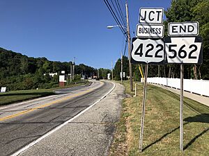
Two main highways serve St. Lawrence: U.S. Route 422 Business and Pennsylvania Route 562.
- PA 562 is also known as St. Lawrence Avenue. It runs east through the town and goes towards Boyertown.
- US 422 Business, or Perkiomen Avenue, runs along the western edge of the borough. It connects St. Lawrence to Mount Penn and the city of Reading to the west. To the southeast, it joins the main US 422 highway, which leads to Pottstown. St. Lawrence is about 51 miles (82 km) northwest of Philadelphia.
The Oley Turnpike used to run through St. Lawrence. This road was special because it was the last privately owned toll road in Pennsylvania.
Population Information
| Historical population | |||
|---|---|---|---|
| Census | Pop. | %± | |
| 1920 | 1,270 | — | |
| 1930 | 1,771 | 39.4% | |
| 1940 | 1,861 | 5.1% | |
| 1950 | 1,982 | 6.5% | |
| 1960 | 2,244 | 13.2% | |
| 1970 | 2,862 | 27.5% | |
| 1980 | 2,617 | −8.6% | |
| 1990 | 2,467 | −5.7% | |
| 2000 | 2,639 | 7.0% | |
| 2010 | 1,809 | −31.5% | |
| 2020 | 1,892 | 4.6% | |
| U.S. Decennial Census | |||
According to the census in 2000, there were 1,812 people living in St. Lawrence. There were 757 households, which are groups of people living together in one home. Most of the people living in the borough were White (about 95%). A small percentage were African American or Asian. About 1.82% of the population identified as Hispanic or Latino.
The population was spread out in terms of age. About 24% of the people were under 18 years old. About 16% were 65 years or older. The average age in the borough was 38 years old.
The average income for a household in St. Lawrence in 2000 was $47,400 per year. For families, the average income was $56,679. A small number of families and individuals had lower incomes.
See also
 In Spanish: St. Lawrence (Pensilvania) para niños
 | Kyle Baker |
 | Joseph Yoakum |
 | Laura Wheeler Waring |
 | Henry Ossawa Tanner |


