Mount Penn, Pennsylvania facts for kids
Quick facts for kids
Mount Penn, Pennsylvania
|
|
|---|---|
 |
|

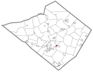
Location of Mount Penn in Berks County, Pennsylvania.
|
|
| Country | United States |
| State | Pennsylvania |
| County | Berks |
| Area | |
| • Total | 0.41 sq mi (1.06 km2) |
| • Land | 0.41 sq mi (1.06 km2) |
| • Water | 0.00 sq mi (0.00 km2) |
| Elevation | 482 ft (147 m) |
| Population
(2020)
|
|
| • Total | 3,240 |
| • Density | 7,902.44/sq mi (3,047.88/km2) |
| Time zone | UTC-5 (EST) |
| • Summer (DST) | UTC-4 (EDT) |
| ZIP code |
19606
|
| Area codes | 610 and 484 |
| FIPS code | 42-51760 |
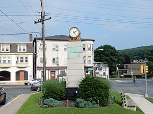
Mount Penn is a small town, called a "borough," located in Berks County, Pennsylvania, USA. In 2020, about 3,240 people lived there. It's named after a nearby mountain, Mount Penn, which is about 1,120 feet (341 meters) tall. This mountain overlooks the city of Reading and is part of the Reading Prong mountain group.
Contents
Exploring Mount Penn's Location
Mount Penn is in the middle of Berks County. The city of Reading is right next to it on the west side. To the east, you'll find the town of St. Lawrence. North of Mount Penn is a community called Pennside, which is part of Lower Alsace Township. There's also another small part of Lower Alsace Township that borders Mount Penn to the south.
The town itself sits in a small dip between the peak of Mount Penn to the north and Neversink Mountain to the south. Neversink Mountain is about 900 feet (274 meters) high.
The United States Census Bureau says that Mount Penn covers about 0.41 square miles (1.06 square kilometers) of land. There is no water area within the borough.
Discovering the Mount Penn Preserve
The Mount Penn Preserve is a large natural area that covers the slopes of Mount Penn, just north of the town. It's a great place to visit! Some famous spots in the Preserve include the Pagoda, a unique building that looks like a Japanese temple. You can also find the William Penn Memorial Fire Tower there. Another popular spot is Antietam Lake Park, which is perfect for outdoor activities. The Preserve also has many local businesses and restaurants to explore.
Mount Penn's Population Over Time
| Historical population | |||
|---|---|---|---|
| Census | Pop. | %± | |
| 1910 | 785 | — | |
| 1920 | 1,370 | 74.5% | |
| 1930 | 3,017 | 120.2% | |
| 1940 | 3,654 | 21.1% | |
| 1950 | 3,635 | −0.5% | |
| 1960 | 3,574 | −1.7% | |
| 1970 | 3,465 | −3.0% | |
| 1980 | 3,025 | −12.7% | |
| 1990 | 2,883 | −4.7% | |
| 2000 | 3,016 | 4.6% | |
| 2010 | 3,106 | 3.0% | |
| 2020 | 3,240 | 4.3% | |
| Sources: | |||
Based on the census from 2000, there were 3,016 people living in Mount Penn. These people lived in 1,278 households, and 829 of those were families. The population density was about 7,077 people per square mile (2,732 people per square kilometer).
Most of the people in Mount Penn were White (96.45%). There were also smaller percentages of African American (1.06%), Asian (1.06%), and Native American (0.03%) residents. About 3.38% of the population identified as Hispanic or Latino.
In 2000, about 30.2% of households had children under 18 living with them. About half (50.4%) of the households were married couples living together. The average household had 2.35 people, and the average family had 2.93 people.
The population was spread out by age:
- 24.5% were under 18 years old.
- 6.8% were between 18 and 24.
- 30.7% were between 25 and 44.
- 21.6% were between 45 and 64.
- 16.3% were 65 years or older.
The average age of people in Mount Penn was 37 years.
Getting Around Mount Penn
As of 2012, Mount Penn had about 9.82 miles (15.80 kilometers) of public roads. The Pennsylvania Department of Transportation (PennDOT) took care of 2.08 miles (3.35 kilometers) of these roads. The rest, about 7.74 miles (12.46 kilometers), were maintained by the borough itself.
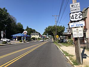
U.S. Route 422 Business is the main highway that goes through Mount Penn. It follows a road called Perkiomen Avenue right through the center of town. This road leads west into downtown Reading and southeast towards Pottstown.
See also
 In Spanish: Mount Penn para niños
 | Roy Wilkins |
 | John Lewis |
 | Linda Carol Brown |


