Starbuck, Minnesota facts for kids
Quick facts for kids
Starbuck, Minnesota
|
|
|---|---|

Starbuck, Minnesota
|
|

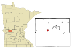
Location of Starbuck, Minnesota
|
|
| Country | United States |
| State | Minnesota |
| County | Pope |
| Platted | Spring of 1882 |
| Incorporated | June 6, 1883 |
| Area | |
| • Total | 1.480 sq mi (3.833 km2) |
| • Land | 1.480 sq mi (3.833 km2) |
| • Water | 0.000 sq mi (0.000 km2) |
| Elevation | 1,165 ft (355 m) |
| Population
(2020)
|
|
| • Total | 1,365 |
| • Estimate
(2022)
|
1,410 |
| • Density | 922.30/sq mi (356.12/km2) |
| Time zone | UTC−6 (Central (CST)) |
| • Summer (DST) | UTC−5 (CDT) |
| ZIP Code |
56381
|
| Area code(s) | 320 |
| FIPS code | 27-62500 |
| GNIS feature ID | 2395956 |
| Sales tax | 6.875% |
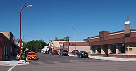
Starbuck is a city in Pope County, Minnesota, United States. In 2020, about 1,365 people lived there. The city sits on the western side of Lake Minnewaska.
Contents
Starbuck's Location and Roads
Starbuck has three main roads. These are Minnesota State Highways 28, 29, and 114. The city covers an area of about 1.48 square miles (3.83 square kilometers). All of this area is land.
The History of Starbuck

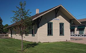
Starbuck was first planned as a village in the spring of 1882. It was built along the Northern Pacific railway, right next to Lake Minnewaska. For many years, it was hard for Pope County to grow. This was because there were no good train lines or shipping options. Settlers had to travel far to sell their goods.
How Starbuck Got Its Name
The town's name might come from a place called Stabekk in Norway. However, a book called Geographical Names of Manitoba has another idea. It says that the village of Starbuck, Manitoba, in Canada, was named after Starbuck, Minnesota. This happened in 1885 by a railway worker.
The book also suggests that Starbuck, Minnesota, was named after William H. Starbuck. He was from New York and helped pay for the Little Falls and Dakota Railroad. Some people also believe the town was named after two oxen. These oxen were named Star and Buck and helped build the railroad.
People Living in Starbuck
| Historical population | |||
|---|---|---|---|
| Census | Pop. | %± | |
| 1890 | 224 | — | |
| 1900 | 469 | 109.4% | |
| 1910 | 497 | 6.0% | |
| 1920 | 824 | 65.8% | |
| 1930 | 781 | −5.2% | |
| 1940 | 972 | 24.5% | |
| 1950 | 1,143 | 17.6% | |
| 1960 | 1,099 | −3.8% | |
| 1970 | 1,138 | 3.5% | |
| 1980 | 1,224 | 7.6% | |
| 1990 | 1,143 | −6.6% | |
| 2000 | 1,314 | 15.0% | |
| 2010 | 1,302 | −0.9% | |
| 2020 | 1,365 | 4.8% | |
| 2022 (est.) | 1,410 | 8.3% | |
| U.S. Decennial Census 2020 Census |
|||
Starbuck's Population in 2010
In 2010, there were 1,302 people living in Starbuck. They lived in 576 households, and 328 of these were families. The city had about 829 people per square mile (320 people per square kilometer). There were 671 homes in total.
Most of the people in Starbuck were White (97.3%). A small number were African American (0.3%), Native American (0.3%), or from other races. About 1.3% of the people were Hispanic or Latino.
About 22.9% of households had children under 18. Many households (42.5%) were married couples. About 36.5% of all households had only one person living there. Also, 19.5% of households had someone aged 65 or older living alone. The average household had 2.14 people.
The average age in Starbuck was 45.8 years old. About 19.9% of residents were under 18. About 25.8% were 65 or older. The city had slightly more females (51.2%) than males (48.8%).
See also
 In Spanish: Starbuck (Minnesota) para niños
 | Claudette Colvin |
 | Myrlie Evers-Williams |
 | Alberta Odell Jones |

