Stob Coire a' Chàirn facts for kids
Quick facts for kids Stob Coire a’ Chàirn |
|
|---|---|

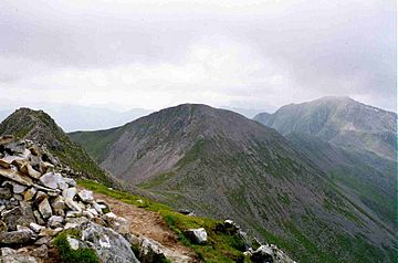
Stob Choire a’ Chàirn with Am Bodach in the distance seen from An Gearanach, One Km to the north.
|
|
| Highest point | |
| Elevation | 981 m (3,219 ft) |
| Prominence | 124 m (407 ft) |
| Parent peak | An Gearanach |
| Listing | Munro |
| Naming | |
| English translation | Peak of the Corrie of the Cairn |
| Language of name | Gaelic |
| Pronunciation | English approximation: STOP-kor-YƏ-kharn |
| Geography | |
| Location | Highland, Scotland |
| Parent range | Mamores |
| OS grid | NN185660 |
| Topo map | OS Landranger 41, OS Explorers 392 |
Stob Coire a’ Chàirn is a mountain in Scotland. It's part of the Mamores mountain range. This mountain is about 3.5 kilometers (2.2 miles) north of a town called Kinlochleven.
Stob Coire a’ Chàirn stands 981 meters (3,218 feet) tall. Even though it's a Munro (a Scottish mountain over 3,000 feet), it's seen as one of the smaller peaks in the Mamores. For a long time, it wasn't even named on maps! Its name comes from Gaelic and means "Peak of the Corrie of the Cairn." A "corrie" is like a bowl-shaped valley, and a "cairn" is a pile of stones.
Contents
What Makes Stob Coire a’ Chàirn Special?
This mountain is super important because of where it is. It's almost right in the middle of the Mamores range. Three ridges, which are like long, narrow mountain tops, spread out from it. These ridges connect Stob Coire a’ Chàirn to other Munros nearby.
The Ring of Steall Walk
Stob Coire a’ Chàirn is famous for being part of an amazing mountain walk called the "Ring of Steall." This walk is known as one of the best ridge walks in all of Scotland!
- The Ring of Steall includes four different Munros.
- Besides Stob Coire a’ Chàirn, you also climb An Gearanach, Am Bodach, and Sgùrr a' Mhàim.
- It's a challenging but very rewarding adventure for hikers.
Mountain Ridges and Paths
Stob Coire a’ Chàirn has three main ridges:
- A northern ridge connects it to An Gearanach.
- A southeast ridge leads to another mountain called Na Gruagaichean.
- A southwest ridge goes towards Am Bodach.
On the southern side of the mountain, there's a wide, open area called Coire na Ba. A stream called Allt Coire na Ba flows through this area. It eventually joins the River Leven near Kinlochleven. There's a really good path in Coire na Ba. It was originally used by deer stalkers (people who hunted deer). This path makes it easier for hikers to reach the main ridge of the Mamores from the south.
How to Climb Stob Coire a’ Chàirn
Most people start their climb of Stob Coire a’ Chàirn from Kinlochleven. They use the stalkers' path up Coire na Ba. This path takes them to the mountain's east ridge, which they follow all the way to the top.
Because Stob Coire a’ Chàirn is so central, hikers often combine climbing it with other Munros in the Mamores. There are many different ways to link up the peaks. At the very top of the mountain, you'll find a simple pile of stones marking the summit. From here, you get fantastic views of Glen Coe and its impressive hills.
 | Stephanie Wilson |
 | Charles Bolden |
 | Ronald McNair |
 | Frederick D. Gregory |

