Am Bodach facts for kids
Quick facts for kids Am Bodach |
|
|---|---|

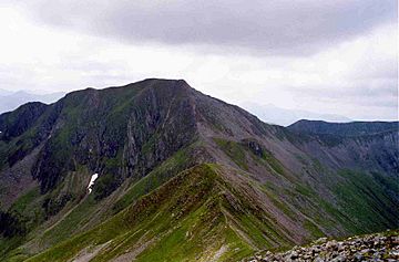
Am Bodach seen from Stob Coire a' Chàirn, 1.5 km to the NE.
|
|
| Highest point | |
| Elevation | 1,032 m (3,386 ft) |
| Prominence | 151 m (495 ft) |
| Parent peak | Sgurr a' Mhàim |
| Listing | Munro, Marilyn |
| Naming | |
| English translation | The Old Man |
| Language of name | Gaelic |
| Pronunciation | English approximation: əm-BOT-əkh |
| Geography | |
| Parent range | Mamores |
| OS grid | NN176650 |
| Topo map | OS Landranger 41, OS Explorer 392 |
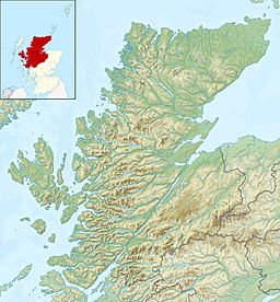
Am Bodach is a Scottish mountain. It is located in the Mamores mountain range. You can find it about four kilometers north of Kinlochleven in the Highland area of Scotland.
Contents
What is Am Bodach?
Am Bodach is a Munro. A Munro is a Scottish mountain that is over 3,000 feet (914.4 meters) high. Am Bodach stands tall at 1032 meters (3386 feet). This makes it the 100th highest Munro! It sits right in the middle of the Mamores range. It's also one of the easiest mountains in the group to reach.
Where does the name come from?
The name Am Bodach comes from the Gaelic language. It means "The Old Man." This name was often given to a mountain that stood out and overlooked a town. People living near Loch Leven probably gave it this name. Am Bodach overlooks this beautiful loch. There is another mountain also called Am Bodach near Glen Coe, so don't get them mixed up!
The Ring of Steall
Am Bodach is a key part of a famous hiking route. This route is called the "Ring of Steall." It's a long walk that connects several Munros. The Ring of Steall starts and finishes in Glen Nevis. Hikers on this route climb Am Bodach. They also climb An Gearanach, Stob Coire a' Chàirn, and Sgurr a' Mhàim. It's a challenging but very rewarding hike!
Am Bodach's Shape
Am Bodach is a striking mountain. It has a sharp peak and three steep, rocky sides. The eastern side, above a place called Coire na Ba, is very steep and craggy. You can often see patches of snow there, even in summer!
Mountain Ridges
Am Bodach has three ridges that spread out from its top.
- One ridge goes west. It connects to a peak called Sgurr an Iubhair.
- Another ridge goes northeast. This one is steep and rocky. It connects to the Munro of Stob Coire a' Chàirn. Hikers doing the Ring of Steall often use these two ridges.
- A third ridge goes south. It passes over a smaller peak called Sgurr an Fhurain. Then it drops steeply down towards Kinlochleven.
How to Climb Am Bodach
You can start climbing Am Bodach from Kinlochleven. This town is at sea level. However, you can also drive to Mamore Lodge. Parking there saves you about 200 meters of climbing!
The Hiking Path
From Mamore Lodge, you walk northwest for about one kilometer. You'll be on an old military road. This road was built by General Caulfield. Today, it's part of the West Highland Way long-distance path. You then leave this track. The climb becomes steep as you head northeast. You'll reach the top of Sgurr an Fhurain first. From there, you continue north to the summit of Am Bodach.
Views from the Top
When you reach the top, you'll see amazing views! You can look out over Glen Coe and Loch Leven. The mountain Bidean nam Bian looks especially impressive from Am Bodach's summit.
See Also
 | Valerie Thomas |
 | Frederick McKinley Jones |
 | George Edward Alcorn Jr. |
 | Thomas Mensah |


