An Gearanach facts for kids
Quick facts for kids An Gearanach |
|
|---|---|

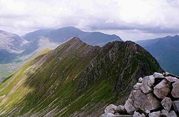
An Gearanach (left) and An Garbhanach (right) from Stob Coire a' Chàirn
|
|
| Highest point | |
| Elevation | 982 m (3,222 ft) |
| Prominence | 151 m (495 ft) |
| Parent peak | Am Bodach |
| Listing | Munro, Marilyn |
| Naming | |
| English translation | short ridge or the complainer |
| Language of name | Gaelic |
| Pronunciation | English approximation: ƏNK-yerr-Ə-nəkh |
| Geography | |
| Parent range | Mamores |
| OS grid | NN187669 |
| Topo map | OS Landranger 41, OS Explorer 392 |
| Listed summits of An Gearanach | ||||
| Name | Grid ref | Height | Status | |
|---|---|---|---|---|
| An Garbhanach | NN188665 | 975 m (3199 ft) | Munro Top | |
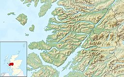
An Gearanach is a Scottish mountain located in the Mamore Forest. It stands about five and a half kilometres (3.4 miles) north of Kinlochleven. This mountain is found in the Lochaber area of the Highland council region.
Contents
An Gearanach: A Scottish Mountain
An Gearanach reaches a height of 982 metres (3,222 feet). This makes it the 167th tallest Munro in Scotland. A Munro is a Scottish mountain over 3,000 feet (914.4 metres) high. With a prominence of 151 metres, it also counts as a Marilyn. A Marilyn is a hill in the British Isles with a prominence of at least 150 metres.
An Gearanach is part of a group of mountains called the Mamores. These mountains are located between Loch Leven and Glen Nevis. The Mamores include 10 Munros and two Corbetts. Corbetts are Scottish mountains between 2,500 and 3,000 feet high. The name "An Gearanach" comes from Gaelic. Some people think it means "short ridge." Others believe it means "the complainer" or "the sad place."
Exploring An Gearanach's Landscape
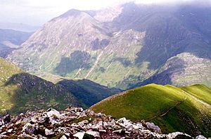
The top part of An Gearanach is a ridge that runs from north to south. It is just over a kilometre (0.6 miles) long. The sides of the mountain drop steeply into two valleys. These are the Allt Coire a' Mhail to the west and the Allt Coire na Gabhalach to the east. At the northern end, three ridges lead down towards upper Glen Nevis. To the south, a ridge goes down to the Bealach a' Chadah, a mountain pass. From there, it continues to the nearby Munro of Stob Coire a' Chàirn.
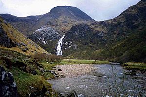
An Gearanach is a popular mountain for hikers. It is part of an amazing and challenging ridge walk called the Ring of Steall. This route includes three other Munros: Stob Coire a' Chàirn, Am Bodach, and Sgùrr a' Mhàim. The Ring of Steall goes around the Allt Coire a' Mhàil glen. This glen feeds the beautiful An Steall Bàn waterfall. The An Steall Bàn, meaning "the white spout," drops 120 metres (394 feet) down the northern slopes of An Gearanach. Hikers often pass the base of these falls when approaching the mountain from Glen Nevis.
An Garbhanach: A Nearby Peak
An Gearanach has a smaller peak nearby called An Garbhanach. Its name means "rough ridge." It is about 400 metres (1,300 feet) to the south. The two peaks are connected by a narrow ridge. This ridge can be tricky in one spot, as it becomes very thin, like a knife edge. It drops steeply into deep glens on both sides. You need a good head for heights to cross it.
For a long time, people weren't sure which peak was taller. On old maps from the 1970s, both An Gearanach and An Garbhanach were shown as 3,200 feet high. In 1921, An Garbhanach was even mistakenly listed as a Munro. An Gearanach was then called a "top" (a smaller peak). This was due to old mapping methods. The mistake was fixed in 1933. The northern slopes of An Gearanach need care when walking down to Glen Nevis. It's important to stay on the marked paths. Some people have gotten into trouble trying to go straight down the crags above the An Steall Bàn waterfall.
How to Climb An Gearanach
You can climb An Gearanach from either Glen Nevis or Kinlochleven. The route from Glen Nevis is shorter. It also offers a lovely walk through the Nevis gorge. You will pass the foot of the An Steall Bàn waterfall. After crossing the Water of Nevis on a wire suspension bridge, a path zigzags up the hillside. This path leads you to the NNE ridge and then to the summit.
The climb from Kinlochleven is longer. First, you go up Stob Coire a' Chàirn using a path up Coire na Ba. Then, you continue to An Gearanach. This round trip is about 14 kilometres (8.7 miles) long.
 | William Lucy |
 | Charles Hayes |
 | Cleveland Robinson |


