Stoneferry facts for kids
Stoneferry is a part of Kingston upon Hull, in East Riding of Yorkshire, England. It used to be a small village on the east side of the River Hull. For a long time, people crossed the river here using a ferry. After 1905, a bridge was built. Today, Stoneferry is mostly an industrial area, with factories and warehouses. It sits on both sides of the River Hull.
The main road, Stoneferry Road (part of the A1033), goes south through Stoneferry towards the center of Hull. Another road, Ferry Lane (part of the A1165), goes east from the Stoneferry bridge for a short distance to meet Stoneferry Road.
Contents
Where is Stoneferry?
Stoneferry is located next to the River Hull on its western side. On the other side of the river are areas like Sculcoates and Newland. To the north, you'll find the Sutton Fields Industrial Estate, which was built after the 1970s. Beyond that is the Bransholme housing estate.
To the north-east and east, there are housing areas called Sutton Ings and Garden Village. South of Stoneferry is Wilmington, which is also an industrial area, much like Stoneferry.
The A1033 Stoneferry Road runs north to south through the area. It connects with the A1165 Clough Road/Ferry Lane using bridges over the River Hull. Chamberlain Road is another important road that goes east towards the Garden Village. A railway line, the Hull Docks Branch, also crosses the southern part of Stoneferry and goes over the river.
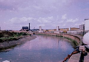
Stoneferry has many industrial buildings, especially along the River Hull. These include places for making things, storing goods, and shops. In the eastern part, there are some houses built at different times, from the late 1800s to the late 1900s. There are also some natural green spaces in this area.
Stoneferry's Ground
Underneath the River Hull, near Stoneferry, there's a layer of harder rock or a mix of materials. This is unusual because most of the riverbed is usually made of soft clay, silt, and mud.
Stoneferry's Past
People have been crossing the river at Stoneferry since at least 1269. Back then, it was called 'Stanfordrak'. The name Stoneferry started being used in the 1300s.
The small village of Stoneferry was originally part of the larger area of Wawne. Later, it became part of the parish of Sutton on Hull.
In 1845, a waterworks was built in Stoneferry on the west side of the river. This was to provide water for the growing town of Hull. Before this, Hull got its water from natural springs near Anlaby. Engineers thought the springs wouldn't provide enough water, so they suggested taking water from the River Hull when the tide was out, hoping it would be fresh. At first, the water seemed good, but soon people complained that it was muddy and salty.
A serious illness called cholera spread in Hull in 1849. This made people look for a better water supply. Some experts still thought more water couldn't come from the Anlaby springs. However, a local person named William Warden believed that digging a deep artesian well would provide enough water. In the 1860s, deep holes were dug, and the Springhead Pumping Station was built. Water from these deep wells was then sent to the Stoneferry waterworks, and they stopped taking water from the river. This solved Hull's water problem. By 1910, the Stoneferry waterworks was no longer used.
In the late 1800s, the area between Hull and Stoneferry started to grow with factories. In 1882, Stoneferry officially became part of Kingston upon Hull. This growth continued, turning the riverbanks and Stoneferry into a completely industrial area by the 1900s. Two railway lines were also built through the area in the 1860s and 1880s.
More houses were built in Stoneferry between 1890 and 1910. Even more housing was added starting in the late 1930s and later. However, some houses built along Sutton Road were knocked down in the 1970s to make way for the Sutton Fields industrial estate. In the 1990s, a small group of new houses was built. Today, Stoneferry is a mix of factories, homes, and green spaces. In 2011, an area called 'Rockford Fields' became a local nature reserve.
In 2012, a company called Barratt got permission to build about 100 homes on playing fields. These fields were given by James Reckitt for the workers of Reckitts of Hull to use for fun. Many local people were against this plan, and Hull councillors rejected it in 2011. But the decision was overturned after an appeal.
Stoneferry's Factories
By the 1850s, Stoneferry had mills that made whiting (a white powder) and oil. By 1910, the riverbanks were filled with factories. These included mills for seed oils, whiting, and related businesses like paint and pigment factories. There was also a cement factory.
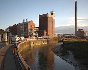
In 1884, a Hull-based company called Reckitt & Sons built a factory in Stoneferry to make a blue pigment called Ultramarine. This factory later became part of Reckitt & Colman and then was sold to Yule Catto, becoming Holliday Pigments. In 2003, it could make about 9,000 tons of pigment each year. The factory had a very tall chimney, 141 meters (463 ft) high, which was the tallest building in Hull. It was used to release gases into the air. A special system was added in the early 2000s to clean the gases, making the chimney less important. The factory closed in 2007.
A cement factory was started in 1878. It changed owners a few times and eventually became Skelsey's Adamant Cement Co. Ltd.. This factory was later replaced by another plant and its site became part of Reckitt's Ultramarine factory. Another cement factory, Hull Portland Cement Co., started in 1889. It was one of the first to use modern rotary kilns in 1903. After several changes in ownership, it became part of Earles cement in 1911. It stopped making cement in 1927. The site was then used to store materials until it was redeveloped into a shopping area called Medina Park around the year 2000.
In 1912, the large Isis Oil Mills was built. It is now a listed building, meaning it's protected because of its history. Other oil seed mills in Stoneferry that no longer exist include the 'King's Mill', HOMCO (Hull Oil Manufacturing Co., Ltd.), and the Premier Oil Extracting Mill. These last two became very large oil mills by the 1920s and were early users of a process called solvent extraction to get oil from seeds. Near HOMCO, there was also a paint factory called Hangers paints.
Around 1913, a short railway line was built off the Hull-Hornsea railway line. This connected to the Stoneferry goods station 53°46′08″N 0°19′33″W / 53.7688°N 0.3259°W and also to the Premier Oil and Cake Mills. This railway line was completely closed by the 1970s.
To the north of the older industrial area, a large industrial park called Sutton Fields Industrial Estate was built by the City Council in the 1970s. It covers about 243 acres (98 ha).
Stoneferry Bridges
People wanted to build a bridge at Stoneferry in the 1700s. However, people in Beverley were against it because they worried it would block the river for boats. In 1905, a swing bridge was finally built. This bridge could swing open to let boats pass. It was 198 feet 8 inches (60.55 m) long and had an opening of 60 feet 8 inches (18.49 m) for ships. It cost a lot of money to build. Also, a tunnel was built 38 feet (12 m) under the river to carry water, gas, and electricity pipes.
The 1905 bridge was designed to have tracks for trams, but a tram line from Hull to Stoneferry was never finished.
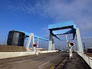
The 1905 swing bridge was replaced by two new lifting bridges between 1988 and 1991. These new bridges are a type called 'Shadoof' bridges and were built about 15 yards (14 m) north of the old one.
Thistleton
53°45′43″N 0°19′21″W / 53.76196°N 0.32261°W Thistleton was a small place located about half a mile south-east of Stoneferry, next to the Foredyke Drain. As Hull grew in the first half of the 1900s, it surrounded Thistleton. By 1950, Thistleton was no longer marked on maps.
 | Lonnie Johnson |
 | Granville Woods |
 | Lewis Howard Latimer |
 | James West |


