
Newland, Kingston upon Hull facts for kids
Quick facts for kids Newland |
|
|---|---|
 Newland Avenue |
|
| Unitary authority | |
| Shire county | |
| Region | |
| Country | England |
| Sovereign state | United Kingdom |
| EU Parliament | Yorkshire and the Humber |
Newland is a lively area in the north-west of Kingston upon Hull, England. It used to be a small village on the road between Hull and Beverley.
For a long time, Newland was a quiet farming area, often a bit swampy. But after 1766, the land was drained and fenced off. In the 1800s, rich merchants from Hull started building their homes here. The first church, St John's, was built in 1833. By the early 1900s, Hull had grown so much that Newland became part of the city.
Today, Newland is home to parts of Hull University. It also includes the popular Newland Avenue, known for its shops. Other important buildings are the former Endsleigh convent and the modern Humberside Police headquarters. The area stretches towards the River Hull, where you'll find businesses and factories.
Contents
Exploring Newland's Location

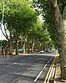
Newland is mainly located around Cottingham Road. This road connects to Beverley Road (A1079) and Newland Avenue. Near Beverley Road is the historic St John's church. You can still see some old 19th-century houses from the original village.
West along Cottingham Road is the Newland Park Estate. On the north side, you'll find Hull University. Newland Avenue runs south from Cottingham Road. East of the main crossroads is Clough Road, which is now an industrial area.
Newland is surrounded by other parts of Hull. To the west are areas like Bricknell Avenue and the North Hull Estate. To the south are The Avenues and Pearson Park. The Clough Road area reaches the River Hull to the east.
Newland Avenue is a very important shopping street. In 2015, it had about 170 shops! The area is mostly homes and schools. It also has many open spaces like playing fields and gardens. The Beverley and Barmston Drain, a large ditch, also runs through Newland. It helps separate the homes from the industrial areas. Newland is very flat and low, less than 5 meters (about 16 feet) above sea level.
Newland's Past: How it Grew
Early Days (Before 1860)

The road through Newland, connecting Beverley and Hull, became a 'turnpike' road in 1744. This meant people had to pay a toll to use it. A toll gate was set up at Newland Bridge.
Around 1797, Newland was known for its rich pasture land. It produced lots of milk and butter for Hull's market. It was described as a "neat little hamlet." Etherington House, a beautiful old farmhouse, was built in the mid-1700s. It was owned by the wealthy Etherington family. This house is a traditional Georgian country house. It has lovely gardens with high brick walls and old trees. The house is considered historically important for Hull.

In the late 1700s, new drainage systems were built. These helped improve the marshy land. The Beverley and Barmston Drain was built after 1798. It crosses Beverley Road, and a cottage from 1785, called "Bridge End Cottage," still stands there. Three houses on Cottingham Road are also from the late 1700s.
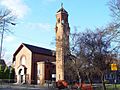
In the early 1800s, wealthy Hull merchants started building large houses in Newland. St John's church was built in 1833. It's made of yellow brick with a slate roof. The church was expanded later in 1893 and 1902. A school, Newland National school, opened nearby in 1865.
A water works was built on the River Hull in 1845. It took water from the river. However, this river water might have caused a cholera outbreak in 1849. After 1860, the water came from a safer source.

By the mid-1850s, Newland was mostly countryside. It was separated from Hull and Cottingham by fields. The main roads met at a crossroads in Newland village. These included Cottingham Road, Clough Road, and the main road to Beverley. Newland village had several large homes with gardens. The church and an inn, the Haworth Arms, were at the crossroads. There were also brick and tile factories in the area.
Some religious groups, called nonconformists, also met in Newland. A Wesleyan chapel was built on Cottingham Road in 1858.
Growing into a Suburb (1860–1913)
In 1862, Newland became its own church parish, separate from Cottingham. By this time, it was seen as a suburb of Hull. In 1871, the road through Newland became free to use, with no more tolls.
The Queen's Hotel was built around 1865. The St John's Hotel also dates from 1865.

The Newland Park Estate was started around 1877. It slowly grew into a fancy housing area for middle-class families. Many houses here have unique architectural styles.

In 1885, the Hull and Barnsley Railway opened. Its branch line to Alexandra Dock passed through the south of Newland.
By the 1890s, Hull's urban area had reached Newland. New housing estates were built, especially around Newland Avenue. Queens Road was also laid out, connecting Newland Avenue to Beverley Road. More brick and tile factories were built.
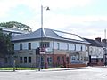
Several important public buildings were constructed around Newland Avenue. The George Lamb Memorial Chapel was built in 1893. St Augustine of Hippo church was built in 1896. St Vincent Primary School opened in 1904. The old Wesleyan chapel was replaced in 1901. Lambert Street school opened in 1879 and was later expanded. Newland Avenue school opened in 1896.

Large "Sailor's Orphan Cottage Homes" were built on Cottingham Road between 1895 and 1898. These homes helped children whose parents were sailors. Many local business people helped fund their construction. St Nicholas Primary School was also built there. A hospital and orphanage were added later.
Endsleigh House, a large house built in 1876, became a convent in 1901. A chapel and a teacher training college were added around 1905.
By 1910, Newland was no longer a separate village. It was fully part of Hull's growing urban area. Housing had filled the space between Newland Avenue and Beverley Road. More homes were built on the west side of Newland Avenue. A leather factory was also established on Cottingham Road.
In 1909, Hull's tram system reached the Newland crossroads. A tram depot was built on Cottingham Road. Hull's Northern Cemetery opened around the end of the 19th century. A chapel was added in 1912.
Between the Wars (1914–1939)

A college for teachers, the Kingston upon Hull Municipal Training College, opened in 1913. It was on the north side of Cottingham Road. The buildings were designed in a grand, traditional style.
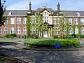
The main building of Newland School for Girls was built in 1914. It was used as a hospital during the First World War. The school itself opened in 1920.
A Catholic boys' school was started in 1925 on Cottingham Road. A Catholic primary school, Endsleigh, was also established in 1927.

In 1925, Hull University was founded. It was built on land given by Thomas Ferens on Cottingham Road. The first students arrived in 1928. The first buildings, Venn and Cohen, were large brick buildings.

The current Haworth Arms pub was built in 1925. A new Methodist church was added in 1928. A Catholic church, St Vincent de Paul, was built in 1932. A women's hospital was built on Cottingham Road in 1932-33.
By the mid-1920s, Hull's growth had extended past Newland village. New housing estates were built, including one around Etherington Road. Housing also expanded around Newland Avenue. Sidmouth Street Primary school was built in 1910.
The Newland Park Estate was mostly developed. New housing estates were built around Cranbrook Avenue and Chanterlands Avenue North. A Baptist chapel was built in 1927. The tram lines were extended, and trolleybuses were introduced from 1936. A new factory, Pearson's Works, was built near the River Hull, making disinfectant.
By the late 1930s, the North Hull Estate was being built to the north. More housing was also developed in other areas, like Bricknell and Kenilworth avenues.
Modern Newland (1940–Present)
During the Second World War, there were anti-aircraft batteries and military camps in Newland. There were also air raid shelters for civilians. St Mary's Grammar school moved to Newland after its original buildings were bombed.
.jpg)
By the 1950s, Newland was mostly developed with homes. The rest of the area was open spaces, like playing fields and the Northern Cemetery. The colleges and university also took up a lot of space. The colleges expanded significantly later in the 20th century. A fire station was built on Clough Road in 1959.
Hull University grew a lot after the war. Many new buildings were added, mostly in red brick. These included the Middleton Hall and Larkin Building (1965–67) and the Gulbenkian Centre (1967–69). The university also added a library, chemistry building, and a sports center. The municipal college also expanded with new blocks.
.jpg)
In 1957, the Catholic church of Our Lady of Lourdes and St Peter Chanel was built. The Endsleigh school was expanded in 1960. A modern church, St Antony's, was added in 1965. A crematorium was built at the Northern Cemetery in 1961. In 1968, a German Lutheran church was built on Cottingham Road.
In 1963, the Frederick Holmes school for handicapped children was established.
The University continued to expand. The Wilberforce building was added in 1968–70. University House (the Student's Union) was built in 1975. Accommodation buildings were added in 1991–92.

In 2001, Hull University took over the college next to its campus. New modern buildings were added. An anatomy building was also built in 2005.
In 2004, the Hull Community church got permission to build a new church. The Sailor's Orphan Homes closed in 2004. The school there is now leased to Hull City Council, and the houses are used for student accommodation. Newland primary school closed in 2006. In 2006, permission was given to build 45 houses on the former Marist College site.
Croda, a chemical company, installed a large wind turbine near its factory around 2008.
.jpg)
In 2012, Humberside Police moved to a new headquarters on Clough Road. A new fire station opened on Clough Road in 2015, replacing the old one.
In 2014, Hull University got permission to build new student accommodation. Work also began in 2014 to create a 'Health Campus' on the former Humberside University site. This included a new five-story building for the Hull York Medical School.
In 2015, a fire badly damaged the old Lambert Street chapel. Much of the church had to be taken down.
Images for kids
-
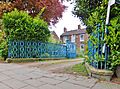
Late 18th century house, former Newland village (2014)
-
St John's church, built 1833 (Postcard, circa 1900)
-
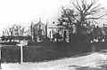
Lambert Street school, built 1879 (F.S. Smith, circa 1888)
-
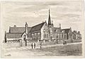
George Lamb Memorial chapel, built 1893 (2007)
-
1914 main block of Newland School for Girls (2008)
-
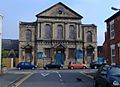
St Vincent de Paul RC church, built 1932 (2008)
-
Community church, Newland Avenue, circa 2005 (2007)
-
Cottingham Road (2009)
.jpg)


