
Stovepipe Wells, California facts for kids
Quick facts for kids
Stovepipe Wells
|
|
|---|---|
.jpg)
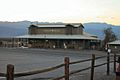
General store and sign at Stovepipe Wells, December 2017
|
|

Stovepipe Wells
Location in California

Stovepipe Wells
Location in the United States
|
|
| Country | United States |
| State | California |
| County | Inyo County |
| Elevation | 10 ft (3 m) |
| Reference #: | 826 |
Stovepipe Wells is a small, unique place in the northern part of Death Valley, California. It's like a rest stop in the middle of a huge desert, offering a place for travelers to stop and get supplies. This area is part of Inyo County and is not officially a city or town.
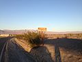
It's located inside Death Valley National Park, which is famous for being one of the hottest places on Earth. Stovepipe Wells is very close to sea level, only about 10 feet (3 meters) above it.
Contents
Exploring Stovepipe Wells and Its Surroundings
Stovepipe Wells is found along State Route 190 (SR 190). This road connects it to other interesting spots in Death Valley.
If you travel west on SR 190, you'll reach Towne Pass, which is much higher, about 4,950 feet (1,509 meters) above sea level. The road then continues to Panamint Valley. If you head east on SR 190, you'll find Furnace Creek and Death Valley Junction.
People sometimes call this place "Stovepipe Wells Village." The name "Stovepipe Wells" comes from a time when a stovepipe was used to mark a hidden water source in the sand.
Stovepipe Wells' Desert Climate
Stovepipe Wells has a very hot desert climate. This means it's usually sunny and dry, with very little rain.
From June through September, the average high temperature is often over 100°F (38°C). It can get extremely hot here, making it important for visitors to stay hydrated and be careful in the summer.
A Brief History of Stovepipe Wells
The story of Stovepipe Wells began around 1906. At that time, a road was being built to help people reach a mine in a place called Skidoo.
A group of tents was set up to provide food, drinks, and a place to sleep for the workers and travelers. This was important because it was the only known water source along that road. When sand started to cover the waterhole, someone put a stovepipe in the ground to mark it. That's how Stovepipe Wells got its unusual name!
Later, in 1925, a person named Bob Eichmann started building a hotel here. He also created a special toll road through Death Valley. This was a big change for the area, shifting it from a mining spot to a place for tourists to visit.
Today, Stovepipe Wells is recognized as a special historical place in California. It's listed as California Historical Landmark #826.
What You Can Find at Stovepipe Wells
Stovepipe Wells Village offers several services for visitors to Death Valley.
You can find the Stovepipe Wells Hotel, which has a swimming pool. There's also a general store where you can buy snacks and other items, and a gas station for cars. For food, you can visit the Badwater Saloon and Toll Road restaurant. There's also The Nugget Gift Shop and a ranger station, where park rangers can help you with information and safety tips.
Cool Places Near Stovepipe Wells
There are many interesting natural features and landmarks close to Stovepipe Wells:
- Sand Dunes: Not far from the village, you can explore large, accessible sand dunes. These dunes stretch for about 7 miles (11 kilometers) and are a popular spot for photos and exploring.
- Original Stovepipe Well: The actual waterhole that gave the community its name is located a bit to the northeast.
- Stovepipe Wells Airport: There's a small airport nearby with a paved runway, used by small planes.
- Stovepipe Wells Campground: A place where visitors can set up tents or park RVs.
- Stovepipe Wells Ranger Station: A base for park rangers to help visitors and manage the park.
- Mesquite Flat Sand Dunes: These are the famous sand dunes mentioned above, known for their beautiful shapes.
- Mosaic Canyon: A narrow canyon with smooth, polished walls, great for hiking.


- Tucki Mountain: A mountain peak visible from the area.
- Grotto Canyon: Another interesting canyon to explore.
- Devil's Corn Field: A unique landscape where clumps of arrowweed grow in a way that looks like cornstalks.
California Historical Landmarks in the Area
Stovepipe Wells is home to three important California Historical Landmarks, which are special places recognized for their history.
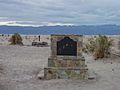
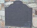
- Old Stovepipe Wells (Number 826): This landmark marks the original waterhole. It was the only water source in the sand dune area and was important for travelers. The stovepipe was put there to mark the spot when sand covered it.
- Eichbaum Toll Road (Number 848): This landmark celebrates the first maintained road into Death Valley from the west. Built by H. W. Eichbaum in 1926, this road helped change the area from mining to tourism. It also led to the creation of Death Valley National Monument seven years later.
- Burned Wagons Point (Number 441): This spot marks where a group of gold seekers, called the "Jayhawkers," had to burn their wagons in 1849. They were trying to find a shortcut to California's gold mines but got stuck in Death Valley. They dried meat from their oxen and continued their journey on foot.
Images for kids
-
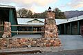
Stovepipe Wells "downtown"
-
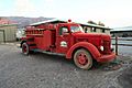
Stovepipe Wells Fire Dept truck
-
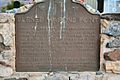
Burned Wagons plaque, California Historical Landmark
-
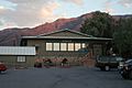
Stovepipe Wells saloon at dusk
-
Stovepipe Wells general store at dusk
-
California Historical Landmark Old Stovepipe Wells
-
California Historical Landmark Eichbaum Toll Road Plaque
-
Sea Level sign in Stovepipe Wells
-
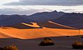
Stovepipe Wells dunes at sunrise


.jpg)
