Stoystown, Pennsylvania facts for kids
Quick facts for kids
Stoystown, Pennsylvania
|
|
|---|---|
|
Borough
|
|

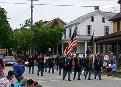
Memorial Day parade
|
|

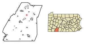
Location of Stoystown in Somerset County, Pennsylvania.
|
|
| Country | United States |
| State | Pennsylvania |
| County | Somerset |
| Settled | 1774 |
| Incorporated | March 29, 1819 |
| Government | |
| • Type | Borough Council |
| Area | |
| • Total | 0.19 sq mi (0.49 km2) |
| • Land | 0.19 sq mi (0.49 km2) |
| • Water | 0.00 sq mi (0.00 km2) |
| Population
(2020)
|
|
| • Total | 300 |
| • Density | 1,578.95/sq mi (609.08/km2) |
| Time zone | UTC-5 (Eastern (EST)) |
| • Summer (DST) | UTC-4 (EDT) |
| Zip code |
15563
|
| Area code(s) | 814 |
| FIPS code | 42-74672 |
Stoystown is a small town, called a borough, located in Somerset County, Pennsylvania, United States. In 2020, about 300 people lived there. Stoystown is found south of Johnstown and northeast of Somerset.
Contents
History of Stoystown
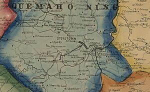
Stoystown has a long and interesting history. Near the town, there was once a small supply base called the Stony Creek Encampment. This base was used during the French and Indian War (1754-1763) to help soldiers. It was located along an old road called Forbes Road.
Who Founded Stoystown?
One of the first people to settle in this area was Daniel Stoy. He was a hunter who lived here around 1762. He sometimes had to hide from Native Americans at Fort Bedford.
Later, Daniel Stoy moved to a new spot and started the town of Stoystown in 1774. This was along a major road at the time, which helped the town grow. Daniel Stoy also served as a soldier in the Revolutionary War.
The Stoystown Historic District and the Hite House are important historical places in Stoystown. They are listed on the National Register of Historic Places, which means they are special places worth protecting.
September 11 Attacks and Flight 93
On September 11, 2001, a sad event happened near Stoystown. United Airlines Flight 93 crashed in nearby Stonycreek Township.
The brave passengers and crew on Flight 93 fought back against terrorists. Because of their actions, the plane did not hit its target. The Flight 93 National Memorial is now located near Stoystown to honor these heroes.
Geography of Stoystown
Stoystown is located at coordinates 40.102753 degrees north and -78.953869 degrees west. The entire borough is surrounded by Quemahoning Township.
The United States Census Bureau says that Stoystown covers a total area of about 0.49 square kilometers (0.19 square miles). All of this area is land.
Population and People
| Historical population | |||
|---|---|---|---|
| Census | Pop. | %± | |
| 1820 | 204 | — | |
| 1840 | 357 | — | |
| 1850 | 321 | −10.1% | |
| 1860 | 316 | −1.6% | |
| 1870 | 288 | −8.9% | |
| 1880 | 319 | 10.8% | |
| 1890 | 291 | −8.8% | |
| 1900 | 306 | 5.2% | |
| 1910 | 355 | 16.0% | |
| 1920 | 342 | −3.7% | |
| 1930 | 447 | 30.7% | |
| 1940 | 461 | 3.1% | |
| 1950 | 517 | 12.1% | |
| 1960 | 360 | −30.4% | |
| 1970 | 446 | 23.9% | |
| 1980 | 432 | −3.1% | |
| 1990 | 389 | −10.0% | |
| 2000 | 428 | 10.0% | |
| 2010 | 355 | −17.1% | |
| 2020 | 300 | −15.5% | |
| 2021 (est.) | 298 | −16.1% | |
| U.S. Decennial Census | |||
In the year 2000, there were 428 people living in Stoystown. These people lived in 184 households. Most of the people in Stoystown were White.
About 26% of the households had children under 18 living with them. Many households were married couples living together. The average age of people in Stoystown was 43 years old.
Transportation
Stoystown is easy to reach by car. It is located near U.S. Route 30, also known as the Lincoln Highway. Route 281 also passes through the area.
See also
 In Spanish: Stoystown para niños
 | Georgia Louise Harris Brown |
 | Julian Abele |
 | Norma Merrick Sklarek |
 | William Sidney Pittman |


