Sturgeon Lake (north Kenora District) facts for kids
Quick facts for kids Sturgeon Lake |
|
|---|---|
| Location | Kenora District, Ontario |
| Coordinates | 55°23′48″N 90°54′19″W / 55.39667°N 90.90528°W |
| Primary inflows | Sturgeon River |
| Primary outflows | Sturgeon River |
| Basin countries | Canada |
| Max. length | 24.4 km (15.2 mi) |
| Max. width | 1 km (0.6 mi) |
| Surface area | 14 km2 (5 sq mi) |
| Shore length1 | 45 km (28.0 mi) |
| Surface elevation | 88 m (289 ft) |
| 1 Shore length is not a well-defined measure. | |
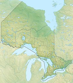
Sturgeon Lake is a long, thin lake located in the Kenora District of Northwestern Ontario, Canada. It's about 200 kilometers (124 miles) from Hudson Bay. The lake is also very close to the border with Manitoba, only about 6.5 kilometers (4 miles) away.
Contents
Where is Sturgeon Lake Located?
Sturgeon Lake is found in a part of Canada called the Kenora District. This area is in the northwestern part of the province of Ontario. It's quite far north, getting close to the huge Hudson Bay.
How Far is it From Manitoba?
This lake is very close to the border that separates Ontario from the province of Manitoba. It's only about 6.5 kilometers (4 miles) from the Manitoba border. This means it's almost right on the edge of two Canadian provinces!
What River Flows Through Sturgeon Lake?
The Sturgeon River is an important river that flows right through Sturgeon Lake. It enters the lake from one side and then flows out the other.
Where Does the Sturgeon River Go?
After leaving Sturgeon Lake, the Sturgeon River continues its journey northwest. Eventually, its waters join up with the Hayes River. The Hayes River then carries all this water all the way to Hudson Bay. So, the water from Sturgeon Lake ends up in one of the largest bays in the world!
 | Selma Burke |
 | Pauline Powell Burns |
 | Frederick J. Brown |
 | Robert Blackburn |


