Sturt County facts for kids
This page is about the New South Welsh cadastral division. For the South Australian cadastral division, see County of Sturt.
Quick facts for kids SturtNew South Wales |
|||||||||||||||
|---|---|---|---|---|---|---|---|---|---|---|---|---|---|---|---|

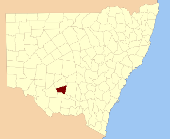
Location in New South Wales
|
|||||||||||||||
|
|||||||||||||||

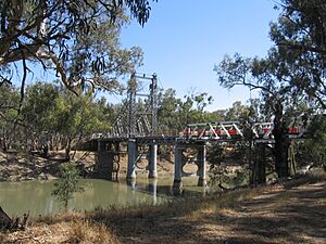
The Carathool Bridge over the Murrumbidgee between Sturt and Boyd
Sturt County is one of the 141 special land areas in New South Wales, Australia. These areas are called cadastral divisions. Think of them like old-fashioned land maps used to keep track of property.
This county includes a place called Carrathool. The Murrumbidgee River forms the southern edge of Sturt County.
Who Was Sturt County Named After?
Sturt County was named to honor a very important person named Charles Sturt (1795-1869). He was an explorer, a soldier, and a public servant. He helped map out and understand many parts of Australia.
What Are Parishes in Sturt County?
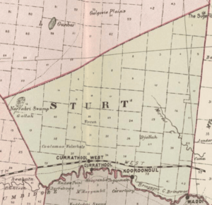
Within Sturt County, there are smaller areas called parishes. These are like tiny local districts. Each parish has its own name and is part of a larger local government area (LGA).
Here is a list of the parishes in Sturt County:
| Parish | Local Government Area | Location |
|---|---|---|
| Alleyne | Carrathool Shire Council | 34°18′54″S 145°28′04″E / 34.31500°S 145.46778°E |
| Baillie | City of Griffith | 34°22′54″S 145°55′04″E / 34.38167°S 145.91778°E |
| Ballingall | City of Griffith | 34°13′54″S 146°00′04″E / 34.23167°S 146.00111°E |
| Beabula | Hay Shire Council | 34°13′54″S 145°11′04″E / 34.23167°S 145.18444°E |
| Bendigo | City of Griffith | 34°21′54″S 145°47′04″E / 34.36500°S 145.78444°E |
| Benerembah | Carrathool Shire Council | 34°28′54″S 145°55′04″E / 34.48167°S 145.91778°E |
| Bringagee | Carrathool Shire Council | 34°25′54″S 145°45′04″E / 34.43167°S 145.75111°E |
| Buckley | Carrathool Shire Council | 34°09′54″S 145°29′04″E / 34.16500°S 145.48444°E |
| Cajaldura | Carrathool Shire Council | 34°23′54″S 145°34′04″E / 34.39833°S 145.56778°E |
| Carrathool | Carrathool Shire Council | 34°22′54″S 145°30′04″E / 34.38167°S 145.50111°E |
| Carrego | Carrathool Shire Council | 34°05′54″S 145°28′04″E / 34.09833°S 145.46778°E |
| Cockburn | Carrathool Shire Council | 34°08′54″S 145°44′04″E / 34.14833°S 145.73444°E |
| Denny | Carrathool Shire Council | 34°02′54″S 145°51′04″E / 34.04833°S 145.85111°E |
| Djallah | City of Griffith | 34°23′54″S 145°51′04″E / 34.39833°S 145.85111°E |
| Downey | Hay Shire Council | 34°11′54″S 145°09′04″E / 34.19833°S 145.15111°E |
| Ercildoune | Carrathool Shire Council | 34°18′54″S 145°35′04″E / 34.31500°S 145.58444°E |
| Hervey | Carrathool Shire Council | 34°10′54″S 145°42′04″E / 34.18167°S 145.70111°E |
| Houlong | Carrathool Shire Council | 34°21′54″S 145°23′04″E / 34.36500°S 145.38444°E |
| Hyde Park | Carrathool Shire Council | 34°18′54″S 145°41′04″E / 34.31500°S 145.68444°E |
| Kooba | Carrathool Shire Council | 34°04′54″S 146°00′04″E / 34.08167°S 146.00111°E |
| Kooroongal | Carrathool Shire Council | 34°23′54″S 145°40′04″E / 34.39833°S 145.66778°E |
| Learmonth | City of Griffith | 34°15′54″S 145°48′04″E / 34.26500°S 145.80111°E |
| Lethington | Carrathool Shire Council | 34°11′54″S 145°26′04″E / 34.19833°S 145.43444°E |
| Livingstone | Carrathool Shire Council | 34°05′54″S 145°37′04″E / 34.09833°S 145.61778°E |
| Maiden | Carrathool Shire Council | 34°02′54″S 145°43′04″E / 34.04833°S 145.71778°E |
| Mair | Carrathool Shire Council | 34°10′54″S 145°37′04″E / 34.18167°S 145.61778°E |
| Mills | Carrathool Shire Council | 34°07′54″S 145°19′04″E / 34.13167°S 145.31778°E |
| Mirrool | City of Griffith | 34°08′54″S 146°02′04″E / 34.14833°S 146.03444°E |
| Munro | Carrathool Shire Council | 34°02′54″S 145°55′04″E / 34.04833°S 145.91778°E |
| North Bringagee | City of Griffith | 34°09′54″S 145°49′04″E / 34.16500°S 145.81778°E |
| North Uardry | Carrathool Shire Council | 34°12′54″S 145°19′04″E / 34.21500°S 145.31778°E |
| O'Brien | City of Griffith | 33°59′54″S 145°53′04″E / 33.99833°S 145.88444°E |
| Quambatook | Carrathool Shire Council | 34°14′54″S 145°36′04″E / 34.24833°S 145.60111°E |
| Tabbita | Carrathool Shire Council | 33°54′54″S 146°02′04″E / 33.91500°S 146.03444°E |
| Tabbita | Carrathool Shire Council | 33°56′54″S 145°57′04″E / 33.94833°S 145.95111°E |
| Terrapee | Carrathool Shire Council | 34°13′54″S 145°31′04″E / 34.23167°S 145.51778°E |
| Toms Point | Carrathool Shire Council | 34°29′54″S 145°14′04″E / 34.49833°S 145.23444°E |
| Uardry | Carrathool Shire Council | 34°20′54″S 145°18′04″E / 34.34833°S 145.30111°E |
| Warburn | City of Griffith | 34°16′54″S 145°53′04″E / 34.28167°S 145.88444°E |
| Wiveon | Carrathool Shire Council | 34°14′54″S 145°42′04″E / 34.24833°S 145.70111°E |
| Wowong | Carrathool Shire Council | 34°28′54″S 145°50′04″E / 34.48167°S 145.83444°E |
| Wycheproof | Carrathool Shire Council | 34°04′54″S 145°32′04″E / 34.08167°S 145.53444°E |
| Yannaway | Carrathool Shire Council | 34°13′54″S 145°25′04″E / 34.23167°S 145.41778°E |
Black History Month on Kiddle
Renowned African-American Artists:
 | Kyle Baker |
 | Joseph Yoakum |
 | Laura Wheeler Waring |
 | Henry Ossawa Tanner |

All content from Kiddle encyclopedia articles (including the article images and facts) can be freely used under Attribution-ShareAlike license, unless stated otherwise. Cite this article:
Sturt County Facts for Kids. Kiddle Encyclopedia.

