Subiaco, Arkansas facts for kids
Quick facts for kids
Subiaco, Arkansas
|
|
|---|---|

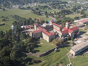
Aerial view of Subiaco Abbey and town, looking South
|
|

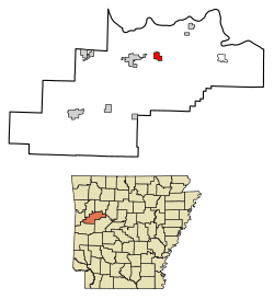
Location of Subiaco in Logan County, Arkansas.
|
|
| Country | United States |
| State | Arkansas |
| County | Logan |
| Area | |
| • Total | 1.91 sq mi (4.94 km2) |
| • Land | 1.89 sq mi (4.90 km2) |
| • Water | 0.01 sq mi (0.04 km2) |
| Elevation | 486 ft (148 m) |
| Population
(2020)
|
|
| • Total | 401 |
| • Density | 211.95/sq mi (81.84/km2) |
| Time zone | UTC-6 (Central (CST)) |
| • Summer (DST) | UTC-5 (CDT) |
| ZIP code |
72865
|
| Area code(s) | 479 |
| FIPS code | 05-67520 |
| GNIS feature ID | 2406677 |
Subiaco is a small town in Logan County, Arkansas, United States. In 2010, about 572 people lived there. The town is named after Subiaco Abbey, a famous monastery located in the area.
The Abbey itself was named by Pope Leo XIII in 1891. It got its name from a city in Italy called Subiaco, where St. Benedict started his very first monastery a long, long time ago. The Abbey gave 80 acres of land in the early 1900s for the town and a railroad connection. The first train arrived in Subiaco in June 1909, which was a big event for the new town!
Contents
History of Subiaco
The town of Subiaco and the Abbey grew together, thanks to the Little Rock and Fort Smith Railroad. In the late 1800s, the railroad company owned a lot of land in Arkansas. They wanted to encourage German Catholic families to move there and settle down.
How the Abbey Started
In 1877, the railroad company made a deal with Abbot Martin Marty. He was a leader from a monastery in Indiana called St. Meinrad Archabbey. The railroad agreed to give the Abbey 640 acres of land in Logan County. The idea was to build a monastery for monks and a school for the new settlers. They also gave 100 more acres to start a convent for Benedictine nuns.
The local bishop, Edward Fitzgerald, supported this plan. He needed German-speaking priests to help the many German immigrants moving into his area.
In March 1878, three monk-missionaries from St. Meinrad Archabbey arrived and started what was first called St. Benedict's Priory. A priory is a smaller monastery. More monks joined them the next year. In 1886, the priory became independent. Then, in 1891, Pope Leo XIII officially named it an Abbey, calling it Subiaco Abbey.
The Railroad Comes to Town
Many German Catholic immigrants moved to the area and became farmers. They really wanted a direct railroad connection to help them transport their goods. There was a nearby town called Spierlerville, Arkansas, which had the local post office. The Spieler family wanted the railroad to go through their town.
However, the leader of Subiaco Abbey, Father Wolfgang Schlumpf, wanted the railroad to pass by the Abbey's stone quarry. This would help the Abbey sell stone and make money. But the railroad company chose an easier, flatter path that went south of the Abbey's land.
So, Subiaco Abbey decided to help create a new town. They donated 80 acres of land for the new town of Subiaco. This is where a railroad depot could be built. A store opened by Conrad Elsken and the new depot became the center of the settlement. A company was even started to sell land to people who wanted to live there.
The very first train arrived in Subiaco on June 22, 1909. The official opening of the railroad was on June 30, 1909. Abbot Ignatius Conrad from Subiaco Abbey even helped by driving in the last spike for the railway! He was dressed in his special robes and blessed the train. Everyone celebrated with music from both the Subiaco band and the band from Spielerville.
Geography and Climate
Where Subiaco Is Located
Subiaco is located in Logan County, Arkansas. According to the United States Census Bureau, the town covers about 1.9 square miles (4.9 square kilometers) of land. There is no water area within the town limits.
Subiaco's Weather
The weather in Subiaco has hot, humid summers and mild to cool winters. This type of weather is called a humid subtropical climate. On climate maps, it's often shown as "Cfa."
| Climate data for Subiaco, Arkansas (1991–2020 normals, extremes 1897–present) | |||||||||||||
|---|---|---|---|---|---|---|---|---|---|---|---|---|---|
| Month | Jan | Feb | Mar | Apr | May | Jun | Jul | Aug | Sep | Oct | Nov | Dec | Year |
| Record high °F (°C) | 83 (28) |
88 (31) |
95 (35) |
96 (36) |
103 (39) |
110 (43) |
115 (46) |
117 (47) |
109 (43) |
100 (38) |
88 (31) |
81 (27) |
117 (47) |
| Mean maximum °F (°C) | 70.3 (21.3) |
73.5 (23.1) |
81.3 (27.4) |
86.4 (30.2) |
90.5 (32.5) |
94.7 (34.8) |
99.5 (37.5) |
99.9 (37.7) |
94.9 (34.9) |
87.9 (31.1) |
77.8 (25.4) |
71.3 (21.8) |
101.5 (38.6) |
| Mean daily maximum °F (°C) | 48.7 (9.3) |
54.1 (12.3) |
63.0 (17.2) |
72.4 (22.4) |
80.1 (26.7) |
87.9 (31.1) |
92.4 (33.6) |
91.8 (33.2) |
84.6 (29.2) |
73.8 (23.2) |
61.2 (16.2) |
51.2 (10.7) |
71.8 (22.1) |
| Daily mean °F (°C) | 38.7 (3.7) |
43.0 (6.1) |
51.5 (10.8) |
60.4 (15.8) |
69.3 (20.7) |
77.4 (25.2) |
81.5 (27.5) |
80.4 (26.9) |
73.1 (22.8) |
62.0 (16.7) |
50.1 (10.1) |
41.3 (5.2) |
60.7 (15.9) |
| Mean daily minimum °F (°C) | 28.6 (−1.9) |
31.9 (−0.1) |
40.0 (4.4) |
48.4 (9.1) |
58.5 (14.7) |
66.8 (19.3) |
70.5 (21.4) |
68.9 (20.5) |
61.6 (16.4) |
50.2 (10.1) |
38.9 (3.8) |
31.5 (−0.3) |
49.7 (9.8) |
| Mean minimum °F (°C) | 13.9 (−10.1) |
18.4 (−7.6) |
24.1 (−4.4) |
34.1 (1.2) |
44.6 (7.0) |
57.0 (13.9) |
62.5 (16.9) |
60.7 (15.9) |
47.6 (8.7) |
34.4 (1.3) |
24.4 (−4.2) |
18.2 (−7.7) |
10.8 (−11.8) |
| Record low °F (°C) | −16 (−27) |
−17 (−27) |
7 (−14) |
24 (−4) |
30 (−1) |
45 (7) |
50 (10) |
47 (8) |
34 (1) |
21 (−6) |
13 (−11) |
−4 (−20) |
−17 (−27) |
| Average precipitation inches (mm) | 3.49 (89) |
2.93 (74) |
4.39 (112) |
4.79 (122) |
5.06 (129) |
3.96 (101) |
3.76 (96) |
4.06 (103) |
3.93 (100) |
3.96 (101) |
4.88 (124) |
4.07 (103) |
49.28 (1,252) |
| Average snowfall inches (cm) | 0.4 (1.0) |
1.0 (2.5) |
0.6 (1.5) |
0.0 (0.0) |
0.0 (0.0) |
0.0 (0.0) |
0.0 (0.0) |
0.0 (0.0) |
0.0 (0.0) |
0.0 (0.0) |
0.0 (0.0) |
0.2 (0.51) |
2.2 (5.6) |
| Average precipitation days (≥ 0.01 in) | 6.8 | 7.2 | 9.0 | 8.0 | 9.7 | 8.2 | 7.7 | 6.8 | 6.4 | 7.0 | 7.6 | 7.4 | 91.8 |
| Average snowy days (≥ 0.1 in) | 0.3 | 0.5 | 0.2 | 0.0 | 0.0 | 0.0 | 0.0 | 0.0 | 0.0 | 0.0 | 0.0 | 0.2 | 1.2 |
| Source: NOAA | |||||||||||||
People of Subiaco
| Historical population | |||
|---|---|---|---|
| Census | Pop. | %± | |
| 1920 | 181 | — | |
| 1930 | 195 | 7.7% | |
| 1940 | 202 | 3.6% | |
| 1950 | 191 | −5.4% | |
| 1960 | 290 | 51.8% | |
| 1970 | 375 | 29.3% | |
| 1980 | 744 | 98.4% | |
| 1990 | 538 | −27.7% | |
| 2000 | 439 | −18.4% | |
| 2010 | 572 | 30.3% | |
| 2020 | 401 | −29.9% | |
| U.S. Decennial Census | |||
In 2000, there were 439 people living in Subiaco. These people made up 147 households and 115 families. The town had about 238 people per square mile.
Most of the people in Subiaco were White (93.62%). There were also some Black or African American people (3.64%), Native American people (0.46%), and Asian people (0.23%). About 1.82% of people were from two or more races. A small number (0.68%) were Hispanic or Latino.
Households and Families
Out of the 147 households, about 38.8% had children under 18 living with them. Most households (63.9%) were married couples living together. About 9.5% had a female head of household with no husband present. Around 21.1% were not families.
About 17.7% of all households were made up of single individuals. And 10.9% of households had someone living alone who was 65 years old or older. On average, there were 2.53 people in each household and 2.86 people in each family.
Age and Income
The population of Subiaco was spread out by age. About 20.3% were under 18 years old. Around 9.6% were between 18 and 24. About 26.0% were between 25 and 44, and another 26.0% were between 45 and 64. Finally, 18.2% of the people were 65 years old or older. The average age in the town was 40 years.
For every 100 females, there were about 122.8 males. If you looked at just adults (18 and over), there were about 131.8 males for every 100 females.
The average income for a household in the town was $38,182. For families, the average income was $40,417. Men generally earned more, with an average income of $25,125, compared to $17,969 for women. The average income per person in the town was $14,012. About 6.0% of families and 17.7% of the total population lived below the poverty line. This included 16.7% of those under 18 and 36.0% of those 65 or older.
Education in Subiaco
Most of the students in Subiaco attend schools in the Scranton School District. The main high school for this district is Scranton High School. A smaller part of Subiaco is in the Paris School District.
There is also a private school in Subiaco called Subiaco Academy.
Images for kids
See also
 In Spanish: Subiaco (Arkansas) para niños


