Sully, Vale of Glamorgan facts for kids
Quick facts for kids Sully
|
|
|---|---|
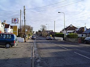 Part of South Road, the main village road, facing East towards Penarth and Cardiff |
|
| Population | 4,543 (Community and ward 2011) |
| OS grid reference | ST155683 |
| Community |
|
| Principal area |
|
| Ceremonial county | |
| Country | Wales |
| Sovereign state | United Kingdom |
| Post town | PENARTH |
| Postcode district | CF64 |
| Dialling code | 029 |
| Police | South Wales |
| Fire | South Wales |
| Ambulance | Welsh |
| EU Parliament | Wales |
| UK Parliament |
|
| Welsh Assembly |
|
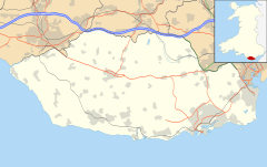
Sully (called Sili in Welsh) is a village located in the Vale of Glamorgan, Wales. It sits right on the northern coast of the Bristol Channel, which is a large bay. Sully is positioned between the towns of Penarth and Barry, and it's about 7 miles (11 km) southwest of Cardiff, the capital city of Wales.
Contents
What's in a Name?
The name Sully (or Sili) has an interesting past! It most likely comes from a Norman family, the de Sullys, who owned the land here way back in the 1100s. This means both the English and Welsh names probably came from that old Norman name.
For a long time, the Welsh name Sili has been used in books and by people living nearby. However, some people in Sully have felt that the Welsh name Sili doesn't sound as good as Sully.
Some have suggested a different Welsh name, Abersili. This name means 'the mouth of the river Sili'. But the small stream in Sully doesn't actually reach the sea at Sully itself; it joins another river further west. So, Abersili isn't really accurate for the village. The Welsh Language Board has confirmed that Sili is the correct and widely used Welsh name for the village.
Sully Through Time
Early History
Sully might have gotten its name from "south lea," meaning "southern pasture." But it's more likely named after Baron Reginald de Sully, a Norman knight. He was one of the "Twelve Knights of Glamorgan" and was given the area around 1093.
Sir Reginald de Sully built a small castle in Sully. Most of it is gone now, but you can still see a small part of a wall near the old Norman church. This castle was quite small, covering only about half an acre. People lived in the castle for less than 300 years, until the de Sully family line ended in the mid-1300s.
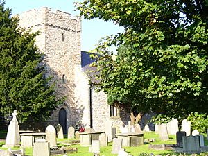
The church in Sully, dedicated to St. John the Baptist, was built around the same time as the castle.
You can also find an old lime kiln on Ashby Road. It's a stone and brick structure, about 40 feet long and 18 feet high, used to make lime. There's also an old cottage called Briarside and Middleton Cottage on Cog Road, built in the mid-1500s. It even has an original circular stone staircase!
Changes in Ownership
After the de Sully family, the land of Sully became owned by the King. In 1538, it was sold to the Stradling family, who owned it for 200 years. After that, it changed hands several times, passing through families like the Mansels, Tyrwhitts (who later changed their name to Drake), and Evan Thomas.
In 1838, a very rich man named Sir Josiah John Guest bought the estate. His son later became the first Lord Wimborne. In 1889, Lord Wimborne even bought the rights to use the Sully coastline for his estate.
By the early 1900s, Lord Wimborne's family started selling off parts of the Sully land. In 1914, the last parts of the estate were sold to private owners. One main buyer was Charles E. Evans, who later turned his properties into a letting company in 1956.
How Sully Grew
In the 1800s, Sully was mostly farmland, with only about 150 to 200 people living there. Even by 1920, the population was still only 550, even though nearby towns like Penarth and Barry were growing fast.
However, in the last 40 years, Sully has grown a lot! This is partly because of plastics factories being built nearby and more people owning cars. Today, Sully is mainly a place where people live and travel to work in Cardiff. Its population is now over 5,000.
From 1890 until the late 1960s, Sully had a railway line that connected it to Penarth, Cardiff, Barry, and the South Wales Valleys. But in 1968, many smaller railway lines across the country were closed down, including the one in Sully. So, Sully railway station closed. Parts of the old railway track are now private land or overgrown, but some sections have become a walking and cycling path.
In the 1960s, a local plastics factory built a new sports and social club in Sully. In 1966, members of this club started a rugby team, now called 'Sully View RFC'. Today, the Sully Sports & Social Club has several rugby teams that play in local competitions and have even traveled to other countries!
The Shipwreck of SS Pilton
The Pilton was a ship that got stuck on Sully Beach in 1924. It happened during a big storm in December 1924. The ship was stuck for three months! This was a big event, and many visitors came by train to see the shipwreck, which helped local businesses like cafes and shops.
How Sully is Governed
Local Community Council
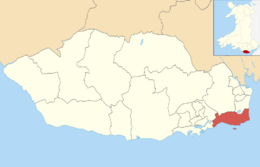
Sully is part of the Sully and Lavernock Community Council. This council has nine members who are elected by the people living in the area. Seven of these councillors represent Sully, and two represent Lavernock.
County Council
Sully is also an electoral ward, which means it elects people to represent it on the Vale of Glamorgan County Council. In the May 2017 election, Sully elected two Independent councillors to the County Council. This council makes decisions about things like schools, roads, and local services for the whole Vale of Glamorgan area.
Important Places in Sully
- St John Baptist Church: This is a very old and important church in Sully, listed as a Grade II building, meaning it's historically significant.
- Swanbridge: This small area includes a caravan park, a holiday camp, and a popular pub called The Captain's Wife. This pub opened in 1977 and was made from old cottages by the sea.
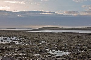
- Sully Island: This is a small island just off the coast of Sully. You can walk to it from the pub car park at low tide, but you need to be very careful! The tides come in quickly and can be dangerous, so you only have about three hours on either side of low tide to visit safely.
- The Bendricks: This area between Sully and Barry is famous for its amazing fossils, making it a special place for scientists who study ancient life.
- Sully School: This is the local primary school, which moved to its current location in 1936. It has a nursery and teaches over 400 students with 17 teachers. There are no secondary schools in Sully, so most children go to Stanwell School in nearby Penarth.
- Sully Hospital: This building is considered a great example of Modernist architecture from between the two World Wars. It's one of the best examples of sanatoriums (hospitals for long-term illness) built in Britain during that time.
Getting Around Sully
The main road through Sully is South Road, which is part of the B4267. This road connects Sully to Barry and Penarth.
As mentioned before, Sully used to have a railway station, but it closed in 1968. Now, the closest train station is Cadoxton, which is about 2.1 miles (3.4 km) away.
Bus services are available in Sully. Cardiff Bus operates route 94, which runs between Cardiff and Barry via Penarth every half hour on weekdays. The journey to Barry takes about 20 minutes, to Penarth about 15 minutes, and to Cardiff just over half an hour. There's also another bus service, route 88, run by Easyway, which connects Lower Penarth and Barry.
Famous People from Sully
- Hana Lili, a pop singer.
- Thomas Frederick Worrall, a watercolour artist.
 | Jewel Prestage |
 | Ella Baker |
 | Fannie Lou Hamer |


