Sunrise, Alaska facts for kids
Quick facts for kids
Sunrise, Alaska
|
|
|---|---|

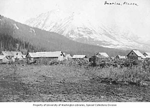
Sunrise in 1909
|
|
| Country | United States |
| State | Alaska |
| Borough | Kenai Peninsula |
| Area | |
| • Total | 13.02 sq mi (33.73 km2) |
| • Land | 13.02 sq mi (33.73 km2) |
| • Water | 0.00 sq mi (0.00 km2) |
| Elevation | 269 ft (82 m) |
| Population
(2020)
|
|
| • Total | 15 |
| • Density | 1.15/sq mi (0.44/km2) |
| Time zone | UTC-9 (Alaska (AKST)) |
| • Summer (DST) | UTC-8 (AKDT) |
| Area code(s) | 907 |
| FIPS code | 02-73950 |
| GNIS feature ID | 1415091 |
|
Sunrise City Historic District
|
|
| Location | Address restricted |
|---|---|
| Nearest city | Hope, Alaska |
| Built | 1895 |
| NRHP reference No. | 97000892 |
| Added to NRHP | August 19, 1997 |
Sunrise is a small community in Alaska, United States. It is located in the Kenai Peninsula Borough. A "census-designated place" (CDP) is a special area defined by the government for counting people. It is not an officially incorporated town.
In 2020, only 15 people lived in Sunrise. This shows how small the community is today.
Contents
Exploring Sunrise's Location
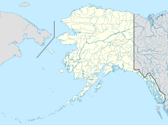
Sunrise is found on the northern part of the Kenai Peninsula. It sits right on the south shore of Turnagain Arm. This arm is a long, narrow branch of Cook Inlet, which is a large body of water.
The community of Hope is located to the west of Sunrise. If you travel south from Sunrise, the Hope Highway leads about 7 miles (11 km) to Alaska Route 1, also known as the Sterling Highway.
Land and Mountains
The entire area of Sunrise is about 13.02 square miles (33.7 square kilometers). All of this land is dry land, with no water areas. Sunrise is nestled in a valley on the west side of Sixmile Creek.
Tall mountains surround the area. Peaks to the west reach about 4,600 feet (1,400 meters) high. To the east, Bradley Peak stands at 3,001 feet (915 meters).
The History of Sunrise
Sunrise was first settled in 1895. It quickly became an official town in 1896. The town grew very fast because of the gold rush. Many miners came to the area in the late 1890s, looking for gold along Turnagain Arm.
Gold Rush Boomtown
For a short time, Sunrise was the biggest city in the Alaska Territory. In 1898, during the summer, about 800 people lived there. The town had several general stores, places to eat, and even a hotel. It was a busy place for miners to get supplies.
Decline and Legacy
After 1900, the town started to shrink. Miners moved to other parts of Alaska where they found more gold. Many of the buildings in Sunrise were later destroyed by fires. The last store in town closed its doors in 1939.
Today, what is left of the old town on both sides of Sixmile Creek is a special historic district. It was added to the National Register of Historic Places in 1997. This means it is an important historical site that is protected.
Population Changes Over Time
Sunrise has seen its population change a lot over the years.
| Historical population | |||
|---|---|---|---|
| Census | Pop. | %± | |
| 1900 | 130 | — | |
| 2000 | 18 | — | |
| 2010 | 18 | 0.0% | |
| 2020 | 15 | −16.7% | |
| U.S. Decennial Census | |||
Sunrise first appeared in the U.S. Census in 1900 as a small village with 130 people. After that, it was not counted in the census for a long time. It reappeared in 2000 as a census-designated place (CDP).
In 2000, the population was 18 people. It stayed the same at 18 people in 2010. By 2020, the number of people living in Sunrise had decreased slightly to 15.
See also
 In Spanish: Sunrise (Alaska) para niños
 | Delilah Pierce |
 | Gordon Parks |
 | Augusta Savage |
 | Charles Ethan Porter |


