
Surat Basin facts for kids
The Surat Basin is a huge area of land in eastern Australia. It's like a giant bowl filled with layers of rock and soil. This basin is part of the even bigger Great Artesian Basin, which holds a lot of underground water.
The Surat Basin covers about 270,000 square kilometres. That's a really big space! A large part of it is in northern New South Wales, and the rest is in Queensland. The rocks inside the basin were formed during the Jurassic and Cretaceous periods, which were millions of years ago.
Many towns in this area used to focus on farming. But now, they are growing fast because of new mines and other big projects happening in the basin.
Contents
How the Basin Formed
The Surat Basin is a type of geological basin called an "intracratonic basin." This means it formed in the middle of a very old, stable part of the Earth's crust.
Millions of years ago, during the Jurassic and Cretaceous periods, rivers carried lots of sand and mud into this area. These materials settled down, layer by layer. Over time, these layers became heavy and caused the ground to slowly sink, creating the bowl-like shape we call a basin. This process is called "sediment sag-loading."
What's Inside the Basin
The Surat Basin sits on top of much older rocks. In the western and central parts, it lies over ancient igneous rocks (formed from cooled lava), metamorphic rocks (changed by heat and pressure), and sedimentary rocks (formed from layers of sediment). These older rocks are part of something called the Lachlan Fold Belt.
In the eastern and northern parts of Queensland, the Surat Basin sits on top of other sedimentary rocks from an even older geological event. The basin also covers parts of the Bowen Basin in southern Queensland and the Gunnedah Basin in central New South Wales.
The edges of the Surat Basin are marked by old, high areas of rock. For example, the Nebine Ridge separates the Surat Basin from another basin called the Eromanga Basin to the west. The Kumbarilla Ridge in Queensland divides the Surat Basin from the Clarence-Moreton Basin to the east.
The basin is mostly flat on the surface. But underground, the layers of rock can be very thick. In Queensland, the basin can be up to 2,500 metres deep. In New South Wales, it can be up to 1,800 metres deep.
One part of the basin, called the Griman Creek Formation, is special. It holds many fossils from the early to middle Cenomanian age.
What the Basin is Used For
The Surat Basin has many natural resources hidden beneath its surface.
More than 100 places where oil and gas have collected have been found here. However, only about half of these places are currently producing oil or gas. The basin is not a major source of oil because the rocks here haven't usually been under the right conditions to create a lot of oil. But it does have some potential for natural gas.
There are also thick layers of coal from the Jurassic period. People have been digging for coal in the Queensland parts of the basin for a long time.
Mines
Several mines operate in the Surat Basin. For example, the Wilkie Creek Mine is located here. Companies like Peabody Energy Australia dig for coal at these mines and then send it to other countries.
Coal Seam Gas
The Surat Basin is also home to many "coal seam gas" fields. This is a type of natural gas found in coal layers deep underground.
This gas is currently used in Australia for things like power stations and heating homes. It travels through pipelines, like the one from Roma to Brisbane.
Some energy companies are planning to build special plants near Gladstone, Queensland to turn this gas into "liquefied natural gas" (LNG). This makes it easier to ship the gas to other countries. The Port of Gladstone is being expanded to handle these new shipments.
In 2010, some energy companies said that their mining activities could affect the levels of underground water. People who farm in the area are especially worried about how this development might impact the environment and their farms.
Images for kids
-
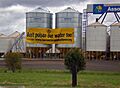
Farmers in Dalby, Queensland are concerned about the environmental and economic impacts of the Surat Basin's development, 2010.

