Bowen Basin facts for kids
Quick facts for kids Bowen Basin |
|
|---|---|

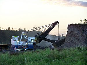
Digging overburden at Dawson Mine near Moura, 2008
|
|

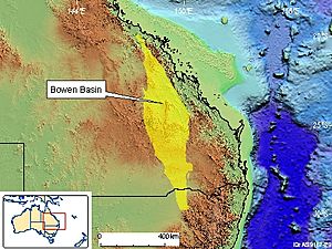
Map showing the location of Bowen Basin in relation to Australia
|
|
| Coordinates | 23°10′39.55″S 148°22′22.80″E / 23.1776528°S 148.3730000°E |
| Etymology | Bowen River, George Bowen |
| Country | |
| State(s) | Queensland, New South Wales (minor) |
| Cities | Collinsville, Theodore |
| Characteristics | |
| On/Offshore | Onshore |
| Boundaries | Atherton Tableland |
| Part of | Galilee Basin |
| Area | ~60,000 km2 (23,000 sq mi) |
| Hydrology | |
| River(s) | Bowen River |
| Geology | |
| Basin type | Rift basin |
| Plate | Australian |
| Orogeny | Hunter-Bowen |
| Age | Permian-Holocene |
| Stratigraphy | Stratigraphy |
| Field(s) | Bowen Basin Coalfields |
The Bowen Basin is a huge area in Central Queensland, Australia. It holds the largest amounts of coal in the country. This region has one of the world's biggest deposits of a type of coal called bituminous coal. It also contains almost all of Queensland's best coking coal, which is used to make steel.
The basin is named after the Bowen River. The river itself was named after Sir George Bowen, who was Queensland's first Governor. The Bowen Basin covers more than 60,000 square kilometres. That's about the size of a small country! It stretches from Collinsville in the north to Theodore in the south. A small reptile called the ornamental snake lives in this area.
Contents
History of the Bowen Basin
The Bowen Basin is about 600 kilometres long and 250 kilometres wide. It holds about 70% of Queensland's coal. This coal formed during the Permian period, millions of years ago. These coal deposits are very important for business. They produce almost all of Queensland's coking coal and 60% of its thermal coal. Thermal coal is used to create electricity.
Early Coal Mining
Coal mining in the Bowen Basin started in the 1890s at a place called Blair Athol. Back then, most coal came from other areas in Queensland. These early mines mainly supplied coal for trains and local power. It was hard for mines in the Bowen Basin to make money because they were far from railways.
Discovering More Coal
More serious searching for coal in the Bowen Basin began in the early 1900s. People started looking for new resources when prices for other metals dropped. In 1912, tests on coal found near the Bowen River caused a lot of excitement. Many groups rushed to claim land for mining.
However, the Queensland government decided to keep a large area for state-run mining. Building a railway line to transport the coal took five years. This long wait meant many early investors gave up. By 1922, when the railway opened, only a few companies remained. One of these was the Bowen Consolidated Coal Mining Company, which opened the Bowen Consolidated Colliery in Scottville.
Coal Mining Today
Most of the coal mines in the Bowen Basin are in the northern part. These include both open-cut mines (where coal is dug from the surface) and underground mines. In 2011, there were 48 active coal mines in the basin. Many new mining projects are being planned.
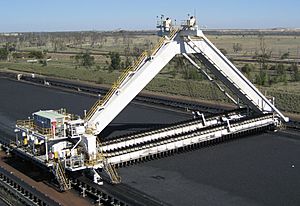
The Goonyella railway line is the main way coal is moved from the mines. It takes coal to ports like Dalrymple Bay and Hay Point for export. Coal is also sent through the Port of Gladstone.
Big Coal Mines in the Basin
The Bowen Basin is home to some very large coal mines. Here are a few examples and how many people they employed in 2011:
- Byerwen Mine: 1,000 workers (still being built then)
- Curragh coal mine: 1,600 workers
- Dawson Central Mine: 1,560 workers
- Goonyella Riverside Mine: 2,360 workers
- Hail Creek coal mine: 1,270 workers
- Peak Downs Mine: 1,760 workers
- Saraji coal mine: 1,615 workers
Many other mines also operate in the basin, including Foxleigh coal mine, Collinsville coal mine, and Kestrel coal mine.
Mining Companies
Many different companies operate mines in the Bowen Basin. Some of the well-known ones include:
- BHP Mitsubishi Alliance
- BHP Mitsui Coal
- Felix Resources
- Idemitsu Kosan
- Macarthur Coal
- Peabody Energy
- QCoal
- Vale
- Wesfarmers
- Glencore
Discoveries and Floods
The first European to find coal in this area was Ludwig Leichhardt in 1845. Later, in 1878, a government geologist named Robert Logan Jack also reported coal deposits. Large-scale exploration of the Bowen Basin really took off in the 1960s.
In 2006, 60% of Australia's exported coking coal came from the Bowen Basin. In 2010, major floods affected almost all the mines in the basin. This meant many mines could not deliver the coal they had promised.
Natural Gas Fields
Besides coal, the Bowen Basin also has important natural gas fields. Natural gas is a clean-burning fuel used for electricity and heating.
Fairview Gas Field
The Fairview gas field is a large project that extracts natural gas from coal seams. It's located about 500-600 kilometres north-west of Brisbane. The company Santos Limited operates this project.
Gas production at Fairview started in 1995. The gas is collected and sent through pipelines to be sold. The project has grown over the years, with more wells being drilled and more gas being produced. There are plans to increase gas production even more in the future.
Scotia Gas Field
The Scotia gas field is another natural gas field in the Bowen Basin. It's about 340 kilometres north-west of Brisbane. Santos Limited also operates this field.
Gas production at Scotia began in 2002. This field supplies natural gas to a power station called Swanbank Power Station. The gas is processed at a central facility and then sent through a pipeline to join a larger gas pipeline system.
Environmental Concerns
Mining and gas extraction can sometimes affect the environment. There have been concerns about plans to expand the Gladstone port at Curtis Island. This port is used to export coal. Some people worry that expanding the port could harm the Great Barrier Reef, which is a World Heritage site. UNESCO, a global organization, has asked for more studies on how the port expansion might affect the reef. There are also worries about pollution of water from the Great Artesian Basin, a huge underground water source.
 | Claudette Colvin |
 | Myrlie Evers-Williams |
 | Alberta Odell Jones |


