
Theodore, Queensland facts for kids
Quick facts for kids TheodoreQueensland |
|||||||||||||||
|---|---|---|---|---|---|---|---|---|---|---|---|---|---|---|---|

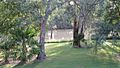
The Boulevard, looking towards the water tower
|
|||||||||||||||

Theodore
Location in Queensland
|
|||||||||||||||
| Population | 451 (2021 census) | ||||||||||||||
| • Density | 205/km2 (530/sq mi) | ||||||||||||||
| Postcode(s) | 4719 | ||||||||||||||
| Elevation | 175 m (574 ft) | ||||||||||||||
| Area | 2.2 km2 (0.8 sq mi) | ||||||||||||||
| Time zone | AEST (UTC+10:00) | ||||||||||||||
| Location |
|
||||||||||||||
| LGA(s) | Shire of Banana | ||||||||||||||
| State electorate(s) | Callide | ||||||||||||||
| Federal Division(s) | Flynn | ||||||||||||||
|
|||||||||||||||
|
|||||||||||||||
Theodore is a small town in the Shire of Banana, Queensland, Australia. It is a rural area, meaning it is mostly countryside with farms. The town was started in the 1920s. It was part of a big plan by Queensland's leader, Ted Theodore, to water farms using the Dawson River. This plan didn't quite happen as expected.
The town was first called Castle Creek. Now, that name belongs to another place nearby. In 2021, about 451 people lived in Theodore.
Contents
Exploring Theodore's Location
Theodore is found on the Dawson River. It is just off the Leichhardt Highway. The town is about 565 kilometers (351 miles) north-west of Brisbane, the state capital. Castle Creek flows through the town. It then joins the Dawson River just south of the town center.
Theodore's Weather
Theodore has a humid subtropical climate. This means it has hot, wet summers. Winters are mild and dry, with cool nights. The highest average temperature is 33.5 degrees Celsius (92.3 F) in December. The lowest average is 21.6 degrees Celsius (70.9 F) in July.
The average rainfall each year is about 732.2 millimeters (28.8 inches). Most of this rain falls during summer. Theodore has about 53 days with rain each year. It also has many clear, sunny days. The hottest temperature ever recorded was 42.0 degrees Celsius (107.6 F). The coldest was -4.4 degrees Celsius (24.1 F).
| Climate data for Theodore (24º57'00"S, 150º04'12"E, 142 m AMSL) (1903-1994 normals, extremes 1965-1990) | |||||||||||||
|---|---|---|---|---|---|---|---|---|---|---|---|---|---|
| Month | Jan | Feb | Mar | Apr | May | Jun | Jul | Aug | Sep | Oct | Nov | Dec | Year |
| Record high °C (°F) | 42.0 (107.6) |
41.1 (106.0) |
39.0 (102.2) |
36.9 (98.4) |
32.2 (90.0) |
27.5 (81.5) |
27.5 (81.5) |
31.8 (89.2) |
34.5 (94.1) |
38.9 (102.0) |
40.6 (105.1) |
41.0 (105.8) |
42.0 (107.6) |
| Mean daily maximum °C (°F) | 33.4 (92.1) |
32.6 (90.7) |
31.3 (88.3) |
29.1 (84.4) |
25.0 (77.0) |
22.0 (71.6) |
21.6 (70.9) |
23.4 (74.1) |
26.6 (79.9) |
30.0 (86.0) |
32.1 (89.8) |
33.5 (92.3) |
28.4 (83.1) |
| Mean daily minimum °C (°F) | 20.4 (68.7) |
20.4 (68.7) |
18.8 (65.8) |
14.9 (58.8) |
10.8 (51.4) |
7.1 (44.8) |
6.2 (43.2) |
7.0 (44.6) |
10.2 (50.4) |
14.4 (57.9) |
17.3 (63.1) |
19.3 (66.7) |
13.9 (57.0) |
| Record low °C (°F) | 15.0 (59.0) |
15.0 (59.0) |
10.0 (50.0) |
5.6 (42.1) |
1.9 (35.4) |
−2.8 (27.0) |
−4.4 (24.1) |
−1.5 (29.3) |
2.0 (35.6) |
4.5 (40.1) |
8.0 (46.4) |
11.5 (52.7) |
−4.4 (24.1) |
| Average precipitation mm (inches) | 103.1 (4.06) |
105.6 (4.16) |
63.0 (2.48) |
48.0 (1.89) |
42.3 (1.67) |
33.2 (1.31) |
37.9 (1.49) |
26.5 (1.04) |
26.3 (1.04) |
61.4 (2.42) |
84.7 (3.33) |
100.6 (3.96) |
732.2 (28.83) |
| Average precipitation days (≥ 1.0 mm) | 6.6 | 6.3 | 4.7 | 3.3 | 3.0 | 3.0 | 3.2 | 2.7 | 2.8 | 4.8 | 6.0 | 6.7 | 53.1 |
| Average afternoon relative humidity (%) | 41 | 46 | 46 | 44 | 47 | 43 | 45 | 40 | 35 | 36 | 38 | 39 | 42 |
| Average dew point °C (°F) | 16.4 (61.5) |
16.7 (62.1) |
15.7 (60.3) |
12.6 (54.7) |
10.6 (51.1) |
6.8 (44.2) |
6.2 (43.2) |
6.2 (43.2) |
7.6 (45.7) |
9.7 (49.5) |
13.1 (55.6) |
15.5 (59.9) |
11.4 (52.6) |
| Mean monthly sunshine hours | 226.3 | 197.8 | 223.2 | 213.0 | 195.3 | 195.0 | 210.8 | 229.4 | 246.0 | 254.2 | 249.0 | 254.2 | 2,694.2 |
| Percent possible sunshine | 54 | 54 | 59 | 62 | 58 | 61 | 63 | 66 | 69 | 65 | 62 | 60 | 61 |
| Source: Bureau of Meteorology (1903-1994 normals, extremes 1965-1990) | |||||||||||||
Theodore's Past: A Look at History
The first people to live in this area were the Aboriginal Gangulu people. Their language, Gangalu, was spoken across this land. It included towns like Clermont and Springsure.
The first European settler was Joseph Thompson in the 1850s. He gathered many large farms for raising animals. Later, James Reid took over these farms. In 1864, a town called Woolthorpe was planned. However, it did not grow at that time. In 1893, William Woolrych bought a huge amount of land. He built it into the very large Woolthorpe Station.
The Dawson River Irrigation Plan
In 1905, government leaders visited the area. They saw that the land was good for sheep. They also saw that a small area was being watered from the Dawson River. They thought the river had enough water to grow many crops. This could help a lot of people live there. But they knew good transport to the coast would be needed.
The idea of a big watering plan for the Dawson River grew. In 1920, Queensland's Premier Ted Theodore supported it. He announced that a large dam would be built. This dam would be at The Gorge on the Dawson River. It would create 100,000 acres of fertile land. This land would be watered by the river.
The plan was to create five farming areas. Each area would have a central town. Theodore was one of these towns. The goal was to support about 50,000 people. Each town would be a "model garden city." This meant it would have all modern services and fun things to do. This was important to attract young people to live in the countryside.
In 1922, the dam was named after Matthew Nathan, the Governor of Queensland. It was planned to be the second largest dam in the world. It would hold a huge amount of water. A railway line was also planned to help the farming area. The money for this big plan was supposed to come from America.
How the Town of Theodore Was Created
Building the big Nathan Dam would take a long time. So, they decided to start smaller. They built a small weir (a low dam) on the Dawson River. Water was pumped from it to the farms. A power station was also built. The first farms were offered for settlement. There were 264 small watered farms and 109 larger dry farms.
The town was first called Castle Creek. This was after the local railway station and a nearby creek. But in November 1926, it was renamed Theodore. This was to honor Ted Theodore, who had strongly supported the irrigation plan.

Theodore State School opened on May 6, 1924. The Castle Creek post office opened in 1924. It was renamed Theodore Post Office in 1927. The Hotel Theodore was first built as a place for new people to stay.

The Theodore branch of the Country Women's Association started around 1928. They opened their first rest rooms in 1932. Their current hall opened in 1953. The land was given for free. The building cost £3,000. It is painted in the CWA's blue and white colors. The Theodore Public Library opened in 1959.
The Nathan Dam Plan Changes
Ted Theodore never got the money for the Nathan Dam. In 1925, he left his job as Premier. In 1933, the dam project was put off for 25 years. Without enough water for irrigation, many small farms around Theodore couldn't make enough money. Many farmers had to sell their land at a loss. This allowed others to buy more land. They made their farms bigger so they could support their families with dry farming.
Because there were fewer families, the town did not grow as big as planned. Many parts of the town's plans became too expensive. This was a disappointment for the settlers. They had been told they would live in a "model garden city."
In 2006, the Queensland Government said the Nathan Dam was still the best water plan. This was to help the growing mining industry. But they said only existing farms would get water. This meant the big irrigation plan would not be fully restarted. The dam was supposed to be ready by 2014.
In 2009, studies found that half of a rare snail population would be in the flooded area. This snail is called the Boggomoss snail. A plan was made to move these snails to other safe places. This trial would delay the dam project. Later, more snails were found in other places. This made people less worried about the snails. However, in 2015, the snail was still listed as "endangered." The dam project is still being reviewed.
Flooding in Theodore
In March 2010, the Dawson River flooded. This caused a lot of damage to the town. On December 28, 2010, another flood happened. The town had to be evacuated. The river level went over 14.6 meters (47.9 feet).
People Living in Theodore
The number of people living in Theodore has stayed about the same.
- In 2011, there were 452 people.
- In 2016, there were 438 people.
- In 2021, there were 451 people.
Theodore's Economy
The town's economy is strongly connected to coal mining. Theodore is at the southern end of Queensland's Bowen Basin. This area is rich in coal.
Learning in Theodore
Theodore State School is a government school. It teaches students from Prep (the first year of school) to Year 10. It is for both boys and girls. The school's motto is 'Learn with a will'. In 2018, the school had 108 students.
For students who want to go to Year 11 and 12, the closest government school is Moura State High School. It is in Moura, to the north-west.
Getting Around Theodore

The Theodore Airport is actually in the nearby area of Lonesome Creek. There are no regular flights from this airport. The community has raised money to put in solar-powered lights. This allows the runway to be used for medical emergency flights at night.
Places to Visit in Theodore

The Banana Shire Council runs a library in Theodore. It is located on The Boulevard.

The Theodore War Memorial honors Australians who have served in wars. It is on the oval in the middle of The Boulevard.
Fun Events in Theodore
The Theodore Annual Show is held every May. The Theodore Show Society organizes this event.
Famous People From Theodore
- Mal Anderson, a tennis champion who won the 1957 U.S. National Championships, was born here.
- Nev Hewitt, who was a Member of the Queensland Parliament, was also born in Theodore.
- Rob Simmons, a rugby union player, played for the Queensland Reds and the New South Wales Waratahs.
Gallery
-
Dawson River at the back of the Hotel Theodore, 2014
-
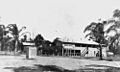
Hotel Theodore, 1938
-
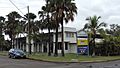
Hotel Theodore, 2014
-
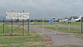
Airport, Theodore, 2014


