Miles, Queensland facts for kids
Quick facts for kids MilesQueensland |
|||||||||||||||
|---|---|---|---|---|---|---|---|---|---|---|---|---|---|---|---|

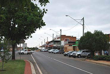
The main street of Miles (looking towards Roma and Charleville)
|
|||||||||||||||
| Population | 1,874 (2021 census) | ||||||||||||||
| • Density | 4.2805/km2 (11.086/sq mi) | ||||||||||||||
| Established | 1878 | ||||||||||||||
| Postcode(s) | 4415 | ||||||||||||||
| Elevation | 302 m (991 ft) | ||||||||||||||
| Area | 437.8 km2 (169.0 sq mi) | ||||||||||||||
| Time zone | AEST (UTC+10:00) | ||||||||||||||
| Location |
|
||||||||||||||
| LGA(s) | Western Downs Region | ||||||||||||||
| State electorate(s) |
|
||||||||||||||
| Federal Division(s) | Maranoa | ||||||||||||||
|
|||||||||||||||
|
|||||||||||||||
Miles is a friendly country town in the Western Downs Region of Queensland, Australia. It's also the name for the surrounding area, called a locality. In 2021, about 1,874 people lived in the Miles area.
Contents
Where is Miles?
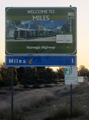
Miles is located on the Warrego Highway. It's about 340 kilometers (211 miles) west of Brisbane, the capital city of Queensland. You can also find it 127 kilometers (79 miles) west of Dalby. It's 48 kilometers (30 miles) west of Chinchilla.
The town is also 141 kilometers (88 miles) east of Roma. It's 406 kilometers (252 miles) east of Charleville.
A Look Back at Miles' History
Miles used to be called Dogwood Crossing. It's built near Dogwood Creek. This creek was named by a German explorer, Ludwig Leichhardt, way back in 1844.
The town was later renamed Miles. This was to honor William Miles, who was an important government official in Queensland at the time. The Miles Post Office opened its doors on January 3, 1878.
Early Schools in Miles
Miles Provisional School first opened on May 31, 1880. It became the Miles State School on January 18, 1886. Holy Cross School also opened in 1926 but closed on December 15, 1989. Miles State High School welcomed its first students on January 30, 1979.
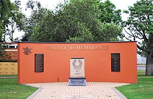
The Miles War Memorial and Wall of Remembrance was built in 1967. It helps people remember those who served in wars.
The Miles Library opened in 2002. It has a fast internet connection. This connects it to Brisbane through the State Library of Queensland.
Who Lives in Miles?
In 2011, the town of Miles had about 1,170 people. By 2016, the wider Miles area was home to 1,746 people. The latest count in 2021 showed the population grew to 1,874 people.
What Miles is Known For
The main way people in Miles make a living is through farming. They grow crops like wheat, sorghum, barley, and cotton. Timber production is also important.
Many people in the area also raise cattle and sheep. There are even feedlots for animals.
Miles is also developing a mining industry. They mine a special type of clay called bentonite. Other growing industries include:
- Coal seam gas
- Coal mining
- Electricity generation
Schools in Miles
Miles has two main schools for students.
- Miles State School is a government primary school. It teaches students from Early Childhood up to Year 6. It's located on Constance Street. In 2018, about 214 students attended the school. It also has a special program for students with disabilities.
- Miles State High School is a government secondary school. It teaches students from Year 7 to Year 12. It's located on Pine Street. In 2018, about 182 students were enrolled. This school also offers a special education program.
Places to Visit and Things to Do
The Western Downs Regional Council runs the Miles Library. It's located at Dogwood Crossing, on the corner of Dawson and Murilla Streets. It offers a fast internet connection for everyone to use.
Redeemer Lutheran Church is at 114 Murilla Street. The Miles branch of the Queensland Country Women's Association has its rooms in Corbett Drive.
Miles Historical Village Museum
The Miles Historical Village Museum is a popular attraction. It's located at 141 Murilla Street. The museum is set up like an old country town street. It has 34 buildings, including 15 old buildings moved from the local area.
Many people think it's one of the best historical villages in Australia. It's even used as a place to film movies and host special events. Every two years in September, Miles hosts the "Miles Back to the Bush Festival." This festival is the town's biggest event. It features bush-style entertainment with a vintage feel.
Getting Around Miles
Miles is connected to other towns by major highways. The Warrego Highway links it to Brisbane, Toowoomba, and Roma. The Leichhardt Highway connects it to Goondiwindi and Rockhampton.
Greyhound Australia buses run daily services through Miles. You can catch a bus to places like Brisbane, Mount Isa, Longreach, and Charleville.
The The Westlander train also stops at Miles twice a week. It travels between Brisbane and Charleville.
Miles also has its own airport, the Miles Airport (WLE). It's located about 19 kilometers (12 miles) south of the town.
Miles' Climate
Miles is located on the Western Downs. It is about 304 meters (997 feet) above sea level. The area around Miles has a fairly dry climate. It has hot summers and mild to warm winters.
In January, the average high temperature is about 33.4°C (92.1°F). In July, the average high is around 19.6°C (67.3°F). Winter mornings can be very cold, and frost is common.
The average rainfall is about 609 millimeters (24 inches) per year. Most of the rain falls between November and March.
| Climate data for Miles (Combined sites, 1885–2014) | |||||||||||||
|---|---|---|---|---|---|---|---|---|---|---|---|---|---|
| Month | Jan | Feb | Mar | Apr | May | Jun | Jul | Aug | Sep | Oct | Nov | Dec | Year |
| Record high °C (°F) | 43.2 (109.8) |
42.1 (107.8) |
41.4 (106.5) |
36.1 (97.0) |
33.0 (91.4) |
31.1 (88.0) |
28.4 (83.1) |
36.2 (97.2) |
39.9 (103.8) |
40.7 (105.3) |
41.9 (107.4) |
43.8 (110.8) |
43.8 (110.8) |
| Mean daily maximum °C (°F) | 33.4 (92.1) |
32.4 (90.3) |
31.0 (87.8) |
27.7 (81.9) |
23.5 (74.3) |
20.0 (68.0) |
19.6 (67.3) |
21.9 (71.4) |
25.8 (78.4) |
29.0 (84.2) |
31.0 (87.8) |
32.7 (90.9) |
27.3 (81.1) |
| Mean daily minimum °C (°F) | 19.9 (67.8) |
19.6 (67.3) |
17.3 (63.1) |
12.9 (55.2) |
7.8 (46.0) |
5.4 (41.7) |
3.9 (39.0) |
5.1 (41.2) |
9.3 (48.7) |
13.4 (56.1) |
16.7 (62.1) |
18.8 (65.8) |
12.5 (54.5) |
| Record low °C (°F) | 10.9 (51.6) |
7.4 (45.3) |
4.3 (39.7) |
0.1 (32.2) |
−4.4 (24.1) |
−5.0 (23.0) |
−6.1 (21.0) |
−4.9 (23.2) |
−2.2 (28.0) |
−0.6 (30.9) |
3.4 (38.1) |
7.9 (46.2) |
−6.1 (21.0) |
| Average rainfall mm (inches) | 84.7 (3.33) |
75.4 (2.97) |
56.3 (2.22) |
35.1 (1.38) |
33.6 (1.32) |
40.6 (1.60) |
26.6 (1.05) |
31.4 (1.24) |
26.1 (1.03) |
43.8 (1.72) |
60.6 (2.39) |
94.6 (3.72) |
608.8 (23.97) |
| Average rainy days (≥ 0.2 mm) | 8.0 | 7.5 | 5.9 | 4.7 | 5.2 | 5.7 | 5.0 | 4.2 | 4.4 | 6.2 | 8.0 | 8.6 | 73.4 |
| Source: Bureau of Meteorology | |||||||||||||
 | Janet Taylor Pickett |
 | Synthia Saint James |
 | Howardena Pindell |
 | Faith Ringgold |


