
Galilee Basin facts for kids
The Galilee Basin is a huge inland area in western Queensland, Australia. It's like a giant bowl in the ground, part of an even bigger system of basins that formed between 360 and 230 million years ago. This system includes the Cooper Basin to the southwest and the Bowen Basin to the east. The Galilee Basin covers about 247,000 square kilometers, which is a really big space! Below it is the Drummond Basin, and on top is the Eromanga Basin. The younger rocks and sediments in the Galilee Basin also form the bottom layers of the famous Great Artesian Basin, which is a massive underground water source.

Contents
- What is the Galilee Basin like?
- Who lives in the Galilee Basin?
- What Animals and Plants Live Here?
- Water in the Galilee Basin
- How the Galilee Basin Formed
- Underground Structures
- Types of Rocks in the Galilee Basin
- What Resources are in the Galilee Basin?
- Infrastructure for Mining
- Ancient Life in the Basin
- Images for kids
What is the Galilee Basin like?
Land and Water
The Galilee Basin is a complex area with many different types of land. It includes parts of several major river systems, like the Lake Eyre, Bulloo, and Murray–Darling river basins. It also reaches into the Burdekin and Fitzroy river basins towards the coast, and the Gulf of Carpentaria in the northwest.
Inside the Galilee Basin, you'll find Lake Buchanan and Lake Galilee. These are special inland wetlands. Lake Buchanan is a salty lake that sometimes dries up, and it can also be a salty marsh. Lake Galilee is similar, but it can also be a seasonal freshwater pond and marsh.
Weather and Climate
The weather in the Galilee Basin is usually hot and dry, especially as you go further west. In summer, daytime temperatures are often around 30-35°C. In winter, overnight temperatures are usually between 5 and 12°C. Records show temperatures can range from -2°C to 44°C! You can expect many "hot days" (over 35°C) – sometimes up to 101 days a year. "Frost days" (below 2°C) are rare, happening only a few times a year.
The air is most humid in the mornings and in February. It's driest in late spring afternoons. The amount of rain changes a lot across the basin, from 150 mm to almost 1,500 mm per year. On average, it gets about 492 mm to 610 mm of rain annually. Most of the rain (about 65%) falls between December and March. January is usually the wettest month, and May is the driest.
Who lives in the Galilee Basin?
Local Communities
The Galilee Basin stretches across 13 different local government areas in Queensland. None of these areas are entirely within the basin, but they all have a part of it. Some of the towns include Barcaldine, Blackall, Charters Towers, Longreach, and Winton.
The main activity on the land here is pastoral grazing, which means raising animals like sheep and beef cattle. This covers more than 95% of the land! About 3% of the land is set aside for conservation.
In 2011, fewer than 20,000 people lived in the Galilee Basin region, which is less than 12 people per square kilometer. The number of people living here has actually gone down a little bit since 2001.
Here are some of the towns in the Galilee Basin and how many people lived there:
| Township | Population |
|---|---|
| Adavale | 141 |
| Alpha | 571 |
| Augathella | 395 |
| Aramac | 299 |
| Barcaldine | 1,655 |
| Blackall | 1,588 |
| Charleville | 3,728 |
| Hughenden | 2,152 |
| Jericho | 369 |
| Middleton | 121 |
| Muttaburra | 106 |
| Richmond | 522 |
| Tambo | 345 |
| Torrens Creek | 64 |
| Total | 12,056 |
Indigenous Heritage and Jobs
The Galilee Basin has a rich Indigenous heritage. At least 12 different Indigenous tribal or language groups have connections to this land. There are also native title claims over large parts of the basin.
The main jobs in the Galilee Basin are in primary production (like farming and grazing), government services, retail, education, and tourism. The most common job (32.5%) is in agriculture, forestry, and fishing, mainly raising sheep and beef cattle. Government services (like local government and health care) are the second biggest employer (19.8%). Other important jobs are in retail, construction, education, transport, and accommodation and food services.
Currently, mining is a small part of the job market (1.3%). However, this could change if new coal mines or gas projects are built.
What Animals and Plants Live Here?
Ecosystems and Plants
The Galilee Basin has many different types of plants and animals. This is because it's a huge area with different climates, eight river basins, and varied landscapes.
The most common types of plants are:
- Mitchell grass (Astrebla) grasslands: These are areas with tall, clumpy grasses.
- Eucalyptus open woodlands: These are forests with eucalyptus trees and grassy areas underneath.
- Cleared land: Areas where native plants have been removed.
Other types of plants grow in different parts of the basin, forming a mix that changes from the northeast to the southwest. About 16% of the woody plants (trees and shrubs) in the eastern part of the basin have been cleared to make more land for pasture (grazing animals). The rate of clearing has slowed down since 2005.
Water and Wildlife
The rivers and streams in the Galilee Basin don't flow all the time; they are often dry. The amount of water and how long it stays determines how many different species live there.
There are also special places called "discharge springs." These are places where underground water comes to the surface under pressure. Many unique species of plants, molluscs, and fish live in these springs. These spring ecosystems need a steady water supply. However, many of these springs have been damaged over the last century because water is being taken for agriculture. Only about 36% of the 300 spring groups found in the Great Artesian Basin in 1900 are still active today.
These springs have also been affected by introduced plants and animals like sheep, pigs, horses, and donkeys. Riverbanks and waterholes are generally in better condition.
Water in the Galilee Basin
Rivers and Underground Water
The Galilee Basin sits on top of the Great Dividing Range, which is a major mountain range. It's where seven big river systems begin, including the Thompson River, Barcoo River, Diamantina River, Flinders River, Bulloo River, and Warrego River. It also includes the headwaters of the Fitzroy and Burdekin river basins. As mentioned before, it has two important wetlands: Lake Buchanan and Lake Galilee.
The basin also contains large underground water sources called aquifers, which are part of the Great Artesian Basin. These aquifers provide water for much of the Galilee Basin and are important areas where the Great Artesian Basin gets refilled. Some of this underground water also comes to the surface as springs or flows into major rivers.
How the Galilee Basin Formed
Geological History
Scientists have different ideas about how the Galilee Basin was formed. Some think it was caused by the land sinking, while others suggest it was due to large cracks in the Earth's crust moving apart. Another idea is that old faults (breaks in the rock) deep underground became active again, causing the land to sink. One theory suggests that the basin formed when a part of the Earth's mantle (the layer below the crust) moved, causing the land to tilt.
More recently, scientists have suggested that the basin started to form when the Earth's crust stretched out about 360 to 290 million years ago. This stretching reactivated older faults. Over time, the basin sank about 2 kilometers, but there were also two big periods when the land was pushed up, about 250 million years ago and again about 100 million years ago.
Rock Layers and Events
At first, the basin filled with fluvial sandstone (sandstone deposited by rivers). Later, other areas also started collecting river and lake sediments. Volcanic ash and sand were deposited around 290 million years ago. Then, the land was squeezed from east to west, creating a break in the rock layers.
Later, the land sank due to heat, and more river sediments, coal, and some marine sandstone were deposited. Another uplift event created another break in the rock layers. After that, rivers deposited quartz-rich sandstone, followed by lake and river mudstone, siltstone, and sandstone. These layers form the bottom part of the Great Artesian Basin. The deposition of sediments ended about 230 million years ago. Later, about 100 to 23 million years ago, the land was compressed again, forming folds in the rock layers over faults.
Underground Structures
The Galilee Basin has three main deep areas where thick layers of rock and coal have built up:
- Lovelle Depression: In the northwest, with over 730 meters of rock from about 290 to 230 million years ago.
- Koburra Trough: In the northeast, with over 2,800 meters of rock from about 360 to 230 million years ago.
- Powell Depression: In the south, with over 1,700 meters of rock from about 290 to 230 million years ago.
These areas are separated from other basins by high underground ridges.
Types of Rocks in the Galilee Basin
Here are the main geological units (layers of rock) found in the Galilee Basin:
| Geological Unit | Age |
|---|---|
| Lake Galilee Sandstone | Late Carboniferous |
| Jericho Formation | Late Carboniferous |
| Jochmus Formation | Early Permian |
| Boonderoo beds | Early Permian |
| Aramac Coal Measures | Early Permian |
| Weston beds | Permian |
| Colinlea Sandstone | Late Permian |
| Betts Creek beds | Late Permian |
| Peawaddy Formation | Late Permian |
| Black Alley Shale | Late Permian |
| Bandanna Formation | Late Permian |
| Rewan Formation | Early Triassic – Middle Triassic |
| Dunda beds | Early Triassic – Middle Triassic |
| Clematis Group | Early Triassic – Middle Triassic |
| Warang Sandstone | Early Triassic – Middle Triassic |
| Moolayember Formation | Middle Triassic |
What Resources are in the Galilee Basin?
Coal and Gas
The Galilee Basin has large amounts of thermal coal, which is used to generate electricity. It's considered a new area for mining in Australia. Currently, there are no large coal mines operating here. Companies are also exploring for coal seam gas, oil, and shale gas. In 1981, it was estimated that there were 800 million tonnes of coal near Alpha alone. By 2008, a company announced finding 4,400 million tonnes of coal!
There are 15 known mineral deposits in the basin, including places like Kevins Corner, Pentland, Alpha, and Carmichael.
Unconventional Gas Exploration
Exploration for coal seam gas is still in early stages. This gas is found in thick coal layers. The gas formed when the coal was buried deep underground, and also later from tiny living things. Some challenges for gas projects here include low gas amounts, being far from markets, and large amounts of water that would need to be removed.
Current Mining Activities
The Galilee Basin has 48 active mining leases, covering about 19.30 square kilometers. These are mostly for small-scale mining of minerals like barite, bentonite, calcite, gypsum, limestone, opals, phosphate, and potassium. There is also one active petroleum production lease. The basin also has 183 active quarry operations, covering 94 square kilometers.
Future Mining Plans
Large deposits of thermal coal are found on the eastern edge of the Galilee Basin. This coal is high-quality, with low sulfur and ash. While no big coal mines are running yet, there are plans for future developments. These proposed coal mining areas would cover about 1.38% of the entire Galilee Basin, mainly for underground mining. There's also some potential for future coal seam gas projects.
Here are some of the proposed coal mining leases and applications:
| Authorised Holder Name | Permit Name | Permit Number | Size km2 | Status |
|---|---|---|---|---|
| ADANI MINING PTY LTD | CARMICHAEL | ML 70441 | 260 | Granted |
| ADANI MINING PTY LTD | CARMICHAEL EAST | ML 70505 | 135 | Granted |
| ADANI MINING PTY LTD | CARMICHAEL NORTH | ML 70506 | 16 | Granted |
| ALPHA COAL PTY LTD | SOUTH GALILEE COAL PROJECT | ML 70453 | 309 | Application |
| HANCOCK COAL PTY LTD | ALPHA | ML 70426 | 324 | Application |
| HANCOCK GALILEE PTY LTD | KEVIN'S CORNER | ML 70425 | 374 | Application |
| MACMINES AUSTASIA PTY LTD | PCS EAST | ML 70514 | 49 | Application |
| MACMINES AUSTASIA PTY LTD | PCS SOUTH | ML 70515 | 47 | Application |
| MACMINES AUSTASIA PTY LTD | PCS WEST | ML 70516 | 47 | Application |
| MACMINES AUSTASIA PTY LTD | PCS CENTRAL | ML 70517 | 32 | Application |
| MACMINES AUSTASIA PTY LTD | PCS NORTH | ML 70518 | 26 | Application |
| WARATAH COAL PTY LTD | NORTH ALPHA MINING LEASE | ML 70489 | 1048 | Application |
| WARATAH COAL PTY LTD | CHINA FIRST COAL PROJECT | ML 70454 | 756 | Application |
Major Coal Projects
The most well-known proposed project is the Carmichael coal mine. In 2014, the Australian government approved Adani's plan for this mine and its railway. This project, costing A$16.5 billion, was expected to be one of the largest coal mines in the world. However, some financial experts have questioned if the project is truly profitable.
Other projects include the Alpha Coal Project by Hancock Coal and GVK. This mine aims to export 30 million tonnes of coal each year. Hancock also plans to develop the Kevin's Corner coal mine nearby.
Another project is the China First mine, owned by Waratah Coal. This mine would affect the Bimblebox Nature Refuge, a protected area. The reserve is partly owned by Paola Cassoni, who wants to protect the endangered black-throated finch that lives there. This mine is planned to export 40 million tonnes of coal a year.
Coal Quality
The coal from the Galilee Basin is considered high-quality. It has low sulfur and ash content, which means it burns efficiently and produces less waste. It also has low levels of trace elements compared to other coals. When burned, it produces about 1.1 tonnes of CO2 per megawatt-hour of electricity, which is similar to other good quality coals from Australia and South Africa.
Here's a look at the quality of some Galilee Basin coal:
| Coal Quality | Alpha | Kevin's Corner | South Galilee Coal Project | Hyde Park Coal Project |
|---|---|---|---|---|
| Total Moisture (% ar) | 17 | 17 | 16 | 14.5 |
| Inherent Moisture (% ad) | 8 | 8.8 | 8.9 | 7.8 |
| Ash (% ad) | 9.5 | 10.6 | 13 | 11 |
| Volatile Matter (% ad) | 33.4 | 33.3 | 34 | 29.5 |
| Total Sulphur (% ad) | 0.56 | 0.5 | 0.9 | 0.3 |
| Fuel Ratio | 1.45 | 1.42 | 1.37 | 1.76 |
| Calorific Value (kcal/kg) (gar) | 5800 | 5790 | 5615 | 5900 |
| Hardgrove Grindability Index | 52 | 49 | 45 | 58 |
Note: ar – as received; ad – air dried; gar – gross as received
Infrastructure for Mining
Galilee Basin State Development Area
To start large-scale coal mining in the Galilee Basin, a lot of money is needed for new railways and port expansions. In 2014, the Queensland Government created the Galilee Basin State Development Area (SDA). This area helps plan and build shared railway lines to the Abbot Point port, aiming to reduce impacts on landowners and the environment.
Abbot Point Coal Terminal
The Abbot Point port is expected to be the main place where coal from the Galilee Basin will be shipped out. Plans to expand the port have caused debate due to worries about how dredging and dumping waste might affect the nearby Great Barrier Reef Marine Park. The current plan involves dumping the dredged material within the terminal area.
Other Infrastructure
There was a plan for a coal-fired power station in the area, but it has been put on hold. The need for water for mines in the basin was once a reason given to support the development of the Bradfield Scheme, a large water diversion project.
Ancient Life in the Basin
In the southeast of the basin, in a rock layer called the Rewan Formation, scientists have found small groups of fossils from an ancient four-legged animal called Lydekkerina.
Images for kids
-
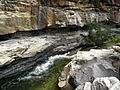
Coal seams of the Betts Creek Beds

