Bulloo River facts for kids
Quick facts for kids Bulloo River |
|
|---|---|

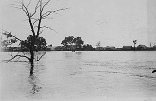
Bulloo River in flood at Adavale, Queensland
|
|
| Country | Australia |
| State | Queensland |
| District | Shire of Bulloo |
| City | Adavale, Thargomindah |
| Physical characteristics | |
| Main source | Grey Range, Idalia National Park western Queensland 290 m (950 ft) |
| River mouth | Bulloo Lake (ephemeral) |
| Length | 600 km (370 mi) |
| Basin features | |
| Basin size | 75,534 km2 (29,164 sq mi) |
The Bulloo River is a special river system in western Queensland, Australia. It's unique because it flows into temporary lakes that can dry up. The river's wide floodplain, which reaches into northern New South Wales, is a very important place for waterbirds when it's flooded. This whole area is part of the Bulloo-Bancannia drainage basin.
Contents
What Makes the Bulloo River Special?
The Bulloo River is different from other rivers in its region. It doesn't connect to the big Murray–Darling basin or the Lake Eyre basin. Instead, it flows into several lakes that only hold water for a short time. These lakes are blocked by small hills from reaching other river systems.
In its lowest parts, the river forms a branch called Bella Creek. Scientists think that in very wet times long ago, the Bulloo River might have connected to Lake Frome. This is because the types of fish found in the Bulloo are similar to those in the Lake Eyre basin. Several smaller streams flow into the upper parts of the Bulloo. The biggest one is Blackwater Creek.
How the River Flows
The Bulloo River acts a lot like the Darling River and Cooper Creek. Most of the time, it's completely dry except for some waterholes. But when there are strong monsoon rains in the summer, the Bulloo can flood heavily. The water flow can be huge, sometimes more than 1000 cubic meters per second!
In very dry years, the whole river basin might get as little as 100 millimeters (4 inches) of rain. Sometimes, there's no water runoff at all.
Weather Around the River
The amount of rain in the Bulloo River basin changes from north to south. In the north, it gets about 330 millimeters (13 inches) of rain each year. In the south, it's drier, with only about 200 millimeters (8 inches) annually. The northern part gets more rain in the summer.
During winter, rain is rare across the basin. From April to October, the average rainfall is only about 115 millimeters (4.5 inches). However, in very rare cases, like in 1920-1921 and 1956, the river has had big floods during the winter. The basin also experienced floods in March 2010 Queensland floods and again in early 2012.
Summer temperatures are usually very hot, unless it's raining a lot. The average high in January is around 38 °C (100 °F), and the average low is about 23 °C (74 °F). In winter, daytime temperatures stay warm, from 20 °C (68 °F) in the south to 25 °C (77 °F) in the north. But it can get cold enough for frost at night.
Wildlife and Land Use
The Bulloo River basin is mostly used for raising sheep and cattle. The only towns in the area are Quilpie, which used to be an opal mining town, and Thargomindah further downstream. There's only one main protected area, Idalia National Park, located where the river starts.
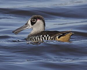
The Bulloo floodplain is a huge area, about 9240 square kilometers. It's so important for birds that BirdLife International calls it an Important Bird Area. When the area floods, hundreds of thousands of waterbirds gather there. This includes more than 1% of the world's populations of birds like the red-necked avocet, grey teal, Australasian shoveler, Pink-eared duck, and freckled duck. It's also home to a special type of grey grasswren that lives nowhere else.
History of the Area
The traditional owners of the land around the Bulloo River are the Kalili people. Their language, Kalili (also known as Galali or Kurnja), is an Australian Aboriginal language. The Kalili language region covers the land within the Paroo Shire and Bulloo Shire. This includes places like Eulo and stretches west towards Thargomindah, covering properties like Bulloo Downs and Currawinya.
 | Madam C. J. Walker |
 | Janet Emerson Bashen |
 | Annie Turnbo Malone |
 | Maggie L. Walker |


