
Quilpie, Queensland facts for kids
Quick facts for kids QuilpieQueensland |
|||||||||||||||
|---|---|---|---|---|---|---|---|---|---|---|---|---|---|---|---|

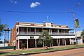
Brolga St, the main street of Quilpie
|
|||||||||||||||

Quilpie
Location in Queensland
|
|||||||||||||||
| Population | 530 (2021 census) | ||||||||||||||
| • Density | 0.02970/km2 (0.0769/sq mi) | ||||||||||||||
| Established | 1917 | ||||||||||||||
| Postcode(s) | 4480 | ||||||||||||||
| Area | 17,847.0 km2 (6,890.8 sq mi) | ||||||||||||||
| Time zone | AEST (UTC+10:00) | ||||||||||||||
| Location |
|
||||||||||||||
| LGA(s) | Shire of Quilpie | ||||||||||||||
| State electorate(s) | Warrego | ||||||||||||||
| Federal Division(s) | Maranoa | ||||||||||||||
|
|||||||||||||||
Quilpie (pronounced KWIL-pee) is a small town and area in Queensland, Australia. It's located in the Shire of Quilpie. In 2021, about 530 people lived in Quilpie.
Quilpie is the main town and administrative center for the entire Shire of Quilpie. Another smaller town, Toompine, is also part of the Quilpie area.
The main ways people make a living here are through farming, especially raising animals, and mining. Quilpie is famous for having one of the world's biggest deposits of a special type of opal called boulder opal. There are also large amounts of natural gas and oil found in the area.
Contents
Exploring Quilpie's Location
Quilpie is located in a region known as Channel Country, right next to the Bulloo River. It sits along the Diamantina Developmental Road. The town is about 211 kilometers (131 miles) west of Charleville. It's also about 829 kilometers (515 miles) west of Toowoomba and 1099 kilometers (683 miles) west of Brisbane, the capital city of Queensland.
The main town of Quilpie is in the northern part of the area. The smaller town of Toompine is located further south. Quilpie has some trees, but sometimes there are droughts, which can make the land very dry.
Quilpie's Past: A Brief History
People believe that Quilpie is located where the lands of the Bunthamurra and Margany Indigenous Australian tribes met.
Margany Language and People
The Margany language is an Australian Aboriginal language spoken by the Margany people. Their traditional lands include the area around Quilpie, Cheepie, and Beechal. It also stretches towards Eulo and Thargomindah, and includes properties like Dynevor Downs and Ardoch.
Early Schools and Settlements
The town of Toompine was first mapped out in 1870. Its name, Toompine, comes from an Indigenous word meaning leech.
Toompine Provisional School and Duck Creek Provisional School both opened in 1900. They were "half-time" schools, meaning they shared one teacher. Toompine Provisional School closed in 1902, allowing Duck Creek Provisional School to have a full-time teacher. However, Duck Creek Provisional School also closed in 1905 due to very few students.
How Quilpie Got Its Name
Quilpie officially became a town in 1917. This happened because the Western railway line from Brisbane was extended to the area. The town's name comes from an Indigenous Australian word, quilpeta, which means stone curlew (a type of bird). A local farmer named James Hammond suggested the name. The railway department first mistakenly called the station Quillpill, but the name was corrected to Quilpie in 1917.
Important Services and Buildings
Quilpie State School opened on September 10, 1918. It started offering high school classes in 1966 and was renamed Quilpie State College in 2008.
The first post office in Quilpie opened in 1921, and telephone service arrived two years later. In 1926, a big fire destroyed part of the main street. Because there was no town water system, people couldn't stop the fire.
The first courthouse was built in 1927.
Local Government Changes
Before 1930, Quilpie was part of the Shire of Adavale. But because the railway line went through Quilpie instead of Adavale, more people moved to Quilpie, making it the bigger town. So, in 1930, the Shire of Adavale was closed, and the Shire of Quilpie was created, with Quilpie as its main center.
Churches in Quilpie
St Finbarr's Catholic Church was officially opened in 1930. It was first built from timber. In 1972, a new brick church was built to replace it. The altar and a special basin for baptisms in the church are decorated with local opals.
St Matthew's Anglican Church opened in 1936. It was made of timber and could seat 100 people. The church bell was a gift from the people of Cunnamulla.
Water and Power
In 1933, a special well was dug into the Great Artesian Basin. This provided drinking water for the town. From 1952 to 1963, the hot water from this well was even used to create electricity for Quilpie!
St Finbarr's School History
St Finbarr's Catholic School opened in 1950 with three Sisters of St Joseph of the Sacred Heart teaching there. By the end of that year, over 60 children were enrolled. A boarding school for boys and girls opened in 1951. The boarding part of the school closed in 2008.
Modern Amenities
The current Quilpie Public Library building opened in 2005.
Who Lives in Quilpie?
In 2021, the Quilpie area had a population of 451 people. About 16.2% of the people identified as Aboriginal and/or Torres Strait Islander.
What Quilpie's Economy Is Like
The main industry in the Quilpie area is grazing, which means raising animals like cattle or sheep. Boulder opal, oil, and gas mining are also very important industries that provide many jobs for local people. Most of the workers in these industries live in Quilpie.
Quilpie has one main opal mining area called the Toompine Field, located between Quilpie and Yowah.
Animals and Plants of Quilpie
You can find many different types of trees in the Quilpie area, including:
- Mulga
- Gidgee
- Red river gum
- Bloodwood
- Sandalwood
- Beefwood
There are also many animals, including reptiles and insects, that live in the area:
- Bearded dragon
- Sand goanna (a type of lizard)
- Black-headed python (a snake)
- Inland taipan (also known as the fierce snake, one of the world's most venomous snakes)
- Mulga snake (also known as the king brown)
- Brolga (a large bird)
- Emu (Australia's largest bird)
- Wedge-tailed eagle (a large bird of prey)
- Red kangaroo
- Eastern grey kangaroo
- Common wallaroo (a type of kangaroo)
- Bilby (a small, endangered marsupial)
- Water rat
- Dingo (a wild dog)
Fun Things and Places in Quilpie

Quilpie has many great facilities that residents can use for free! These include a post office, the town library, a swimming pool, a golf course, a museum, and sports grounds. There's also an air-conditioned hall for events.
The town has well-stocked stores and lots of things for visitors to see, like displays of opals and art by local artists. There's also an information center. The historic Brick Hotel has been restored and now shows off opal and art displays, and it's also a place for community learning.

The Quilpie Shire Library is located at 52 Brolga Street. The Quilpie branch of the Queensland Country Women's Association has its rooms at 17 Brolga Street.
St Finbarr's Catholic Church is on the corner of Bulnbuln Street and Quarrion Street. St Matthew's Anglican Church is on the opposite corner of the same streets.
Schools in Quilpie

Quilpie State College is a government school for students from Early Childhood (Prep) up to Year 10. It's located at the corner of Chulungra and Boonkai Streets. In 2018, the school had 65 students.
St Finbarr's School is a Catholic primary school for students from Prep to Year 6. It's on Jabiru Street. In 2018, there were 26 students enrolled.
For students who want to study Years 11 and 12, the closest high school is Charleville State High School, which is 211 kilometers (131 miles) away in Charleville. Students can also study through distance education (learning from home) or go to boarding schools in other towns.
Quilpie's Weather
Quilpie has a hot, semi-arid climate. This means it has very hot, somewhat rainy summers and mild, dry winters. The average high temperature can be around 37.0°C (98.6°F) in January and 20.1°C (68.2°F) in July.
The town doesn't get a lot of rain, averaging about 347.3 mm (13.7 inches) per year, with most of it falling in summer. Quilpie is a very sunny place, with many clear days each year. The hottest temperature ever recorded was 47.1°C (116.8°F) in January 2014, and the coldest was -2.3°C (27.9°F) in July 1977.
| Climate data for Quilpie (26º36'36"S, 144º15'36"E, 200 m AMSL) (1917-2024 normals, extremes 1957-2014) | |||||||||||||
|---|---|---|---|---|---|---|---|---|---|---|---|---|---|
| Month | Jan | Feb | Mar | Apr | May | Jun | Jul | Aug | Sep | Oct | Nov | Dec | Year |
| Record high °C (°F) | 47.1 (116.8) |
45.5 (113.9) |
42.9 (109.2) |
38.4 (101.1) |
34.5 (94.1) |
32.1 (89.8) |
29.4 (84.9) |
37.0 (98.6) |
40.1 (104.2) |
43.8 (110.8) |
44.9 (112.8) |
46.2 (115.2) |
47.1 (116.8) |
| Mean daily maximum °C (°F) | 37.0 (98.6) |
35.6 (96.1) |
33.4 (92.1) |
29.2 (84.6) |
24.0 (75.2) |
20.4 (68.7) |
20.1 (68.2) |
22.7 (72.9) |
27.1 (80.8) |
31.0 (87.8) |
34.0 (93.2) |
36.3 (97.3) |
29.2 (84.6) |
| Mean daily minimum °C (°F) | 23.8 (74.8) |
23.3 (73.9) |
20.5 (68.9) |
15.6 (60.1) |
10.9 (51.6) |
7.4 (45.3) |
6.1 (43.0) |
7.7 (45.9) |
11.7 (53.1) |
16.1 (61.0) |
19.6 (67.3) |
22.2 (72.0) |
15.4 (59.7) |
| Record low °C (°F) | 13.7 (56.7) |
13.3 (55.9) |
9.6 (49.3) |
3.5 (38.3) |
1.0 (33.8) |
−1.2 (29.8) |
−2.3 (27.9) |
−1.0 (30.2) |
2.1 (35.8) |
5.4 (41.7) |
8.6 (47.5) |
12.3 (54.1) |
−2.3 (27.9) |
| Average precipitation mm (inches) | 52.1 (2.05) |
49.3 (1.94) |
43.6 (1.72) |
24.2 (0.95) |
26.3 (1.04) |
19.6 (0.77) |
16.2 (0.64) |
13.1 (0.52) |
14.9 (0.59) |
22.7 (0.89) |
30.5 (1.20) |
34.4 (1.35) |
347.3 (13.67) |
| Average precipitation days (≥ 1.0 mm) | 4.1 | 3.7 | 3.1 | 1.9 | 2.3 | 2.2 | 2.0 | 1.5 | 1.9 | 2.8 | 3.3 | 3.7 | 32.5 |
| Average afternoon relative humidity (%) | 26 | 31 | 29 | 29 | 35 | 39 | 35 | 28 | 24 | 22 | 21 | 22 | 28 |
| Average dew point °C (°F) | 11.3 (52.3) |
12.3 (54.1) |
10.0 (50.0) |
7.3 (45.1) |
6.3 (43.3) |
4.9 (40.8) |
2.4 (36.3) |
1.3 (34.3) |
1.4 (34.5) |
3.4 (38.1) |
5.7 (42.3) |
7.9 (46.2) |
6.2 (43.1) |
| Source: Bureau of Meteorology (1917-2024 normals, extremes 1957-2014) | |||||||||||||
Events and Festivals
- The Pride of the West festival is held every September.
- The Quilpie Cup Races are also a popular event.
- The Kangaranga Do festival happens every September, on the Tuesday before the Birdsville Races.
Famous People from Quilpie
Some well-known people who come from Quilpie include:
- Vaughan Johnson, a state politician from Queensland.
- Ewen Jones, a federal politician from Australia.
- Donald Markwell, a social scientist and education leader.
- Sandy McPhie, a former state politician from Queensland.
- Justine Saunders, an Australian actor.
Images for kids
-
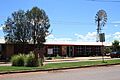
Quilpie Visitors Centre and regional art gallery
-
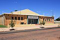
Quilpie Shire Hall
-
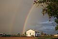
Rainbow over Quilpie - view from behind the Art Gallery
-
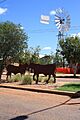
Quilpie public art in the main street
-
Quilpie Hotel
-
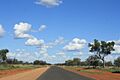
Development Road into Quilpie.
-
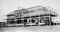
The Imperial Hotel under construction, c.1925
-
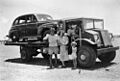
A Brisbane tourist's car being trucked to Quilpie railhead, 1952
-
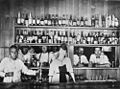
Drinking at the bar of the Quilpie Hotel, c.1921


