
Adavale facts for kids
Quick facts for kids AdavaleQueensland |
|||||||||||||||
|---|---|---|---|---|---|---|---|---|---|---|---|---|---|---|---|

Fencing at Yapunyah in Adavale, 2012
|
|||||||||||||||

Adavale
Location in Queensland
|
|||||||||||||||
| Population | 72 (2021 census) | ||||||||||||||
| • Density | 0.003371/km2 (0.00873/sq mi) | ||||||||||||||
| Established | 1880 | ||||||||||||||
| Postcode(s) | 4474 | ||||||||||||||
| Area | 21,356.4 km2 (8,245.8 sq mi) | ||||||||||||||
| Time zone | AEST (UTC+10:00) | ||||||||||||||
| Location |
|
||||||||||||||
| LGA(s) | Shire of Quilpie | ||||||||||||||
| State electorate(s) | Warrego | ||||||||||||||
| Federal Division(s) | Maranoa | ||||||||||||||
|
|||||||||||||||
Adavale is a small town and area in Queensland, Australia. It is located in the Shire of Quilpie. In 2021, about 72 people lived in the Adavale area.
Contents
Geography
Adavale is in South West Queensland. It is about 931 kilometers (578 miles) west of Brisbane, the capital city of Queensland. The town itself is roughly in the middle of the Adavale area.
You can find a waterhole called Yapunyah between Adavale and Yaraka.
The town can only be reached by gravel road. These roads connect Adavale to Charleville in the east, Quilpie in the south, and Blackall in the north.
Mountains in Adavale
Adavale has some mountains:
- Cave Hill, which is 399 meters (1,309 feet) high.
- Mount Bullock, which is 424 meters (1,391 feet) high.
- Mount Prara, which is 313 meters (1,027 feet) high.
- Winbin Hill, which is 302 meters (991 feet) high.
Protected Areas
There are also special protected areas nearby:
- Part of Idalia National Park is in the north of the area.
- Hell Hole Gorge National Park is in the west.
- Mariala National Park is in the east.
History
Adavale got its name from Ada Constance Stevens. She was the wife of Ernest James Stevens. The Stevens family owned a large property called Tintinchilla (later Milo) in this area.
A fun story says that Ada lost her hat veil (Ada-veil) where the Milo road crosses Blackwater Creek. That's how the town supposedly got its name!
The first town lots in Adavale were sold on February 9, 1881. The Adavale Post Office opened on January 1, 1881, but it closed in 1991.
Schools opened and closed over the years. Milo Station Provisional School opened around 1888. It closed and reopened a few times. Adavale Provisional School opened on October 8, 1888. It became Adavale State School in 1909 and closed on December 31, 1968.
From 1889 to 1930, Adavale was an important local government center. It was first called Adavale Division and then the Shire of Adavale. The town was busy and growing. However, in 1917, the main railway line did not come to Adavale as expected. Instead, it went further south. A new town called Quilpie grew up along the railway line. Quilpie soon became the main town in the region, and Adavale became smaller. In 1930, the local government moved from Adavale to Quilpie. The Shire of Adavale was then renamed the Shire of Quilpie.
St Eugene Catholic Church opened on May 5, 1954. It was damaged by a flood in 1963. It was rebuilt and later moved to a different street. The church has since closed, and the building has been sold.
Population
In 2006, Adavale and the surrounding area had a population of 141 people. The town itself had about 15 people.
In 2016, the Adavale area had 93 people. By 2021, the population of the Adavale area was 72 people.
Education
There are no schools in Adavale or very close by. The nearest schools are in Quilpie. Students can also learn through distance education (learning from home) or by going to boarding schools.
Facilities
- Adavale Cemetery is on Patricia Downs Road, north of the town.
- Adavale Police Station is in Shepherd Street.
- The Adavale SES Facility is on the corner of McKinlay Street and Blackwater Street. The SES helps people during emergencies.
Attractions
Emmet Pocket Lookout is in the Idalia National Park. From here, you can see amazing views over the park's northern areas and the flat plains around it.
Images for kids
-
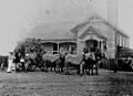
A stagecoach outside Adavale Post Office in 1907.
-
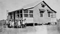
Students at Adavale State School around 1928.
-
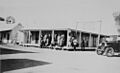
People relaxing on the verandah of the Green Gate Hotel in Adavale, 1928.


