Isisford, Queensland facts for kids
Quick facts for kids IsisfordQueensland |
|||||||||||||||
|---|---|---|---|---|---|---|---|---|---|---|---|---|---|---|---|

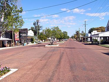
Main street of Isisford
|
|||||||||||||||
| Population | 218 (2021 census) | ||||||||||||||
| • Density | 0.02075/km2 (0.0537/sq mi) | ||||||||||||||
| Postcode(s) | 4731 | ||||||||||||||
| Elevation | 202 m (663 ft) | ||||||||||||||
| Area | 10,506.8 km2 (4,056.7 sq mi) | ||||||||||||||
| Time zone | AEST (UTC+10:00) | ||||||||||||||
| Location |
|
||||||||||||||
| LGA(s) | Longreach Region | ||||||||||||||
| State electorate(s) | Gregory | ||||||||||||||
| Federal Division(s) | Maranoa | ||||||||||||||
|
|||||||||||||||
|
|||||||||||||||
Isisford is a small town and area in the Longreach Region of Queensland, Australia. It's a rural place, meaning it's mostly countryside with farms and open spaces. In 2021, about 218 people lived in Isisford.
Contents
Where is Isisford?
Isisford is located in Central Western Queensland. It sits right on the Barcoo River. The town is about 120 kilometers (75 miles) south-east of Longreach.
Other nearby towns include Emmet, which is 50 kilometers (31 miles) south, and Yaraka, 102 kilometers (63 miles) to the south-west. The Isisford–Blackall Road connects the town to Blackall in the east.
You can also reach Idalia National Park and Welford National Park from Isisford. These are great places to explore nature.
Hills Around Isisford
There are several hills near Isisford, adding to the landscape:
- Double Top (469 meters or 1,539 feet)
- Mount Aaron (334 meters or 1,096 feet)
- Mount Ellen (427 meters or 1,401 feet)
- Mount Grey (426 meters or 1,398 feet)
- Mount Mingera (219 meters or 719 feet)
- Mount Misery (236 meters or 774 feet)
- Mount Perrier (337 meters or 1,106 feet)
- Opal Hill (301 meters or 988 feet)
- Penny Knob (391 meters or 1,283 feet)
- Yellow Mountain (330 meters or 1,083 feet)
Isisford's Weather
| Climate data for Isisford Post Office (1991–2020 normals, extremes 1957–present) | |||||||||||||
|---|---|---|---|---|---|---|---|---|---|---|---|---|---|
| Month | Jan | Feb | Mar | Apr | May | Jun | Jul | Aug | Sep | Oct | Nov | Dec | Year |
| Record high °C (°F) | 47.0 (116.6) |
46.1 (115.0) |
44.6 (112.3) |
40.0 (104.0) |
36.4 (97.5) |
33.3 (91.9) |
33.4 (92.1) |
36.8 (98.2) |
41.0 (105.8) |
43.6 (110.5) |
46.0 (114.8) |
46.6 (115.9) |
47.0 (116.6) |
| Mean daily maximum °C (°F) | 37.2 (99.0) |
36.2 (97.2) |
35.1 (95.2) |
31.7 (89.1) |
27.0 (80.6) |
23.9 (75.0) |
23.8 (74.8) |
26.2 (79.2) |
30.4 (86.7) |
33.8 (92.8) |
35.9 (96.6) |
37.1 (98.8) |
31.5 (88.7) |
| Daily mean °C (°F) | 30.5 (86.9) |
29.6 (85.3) |
28.1 (82.6) |
24.2 (75.6) |
19.5 (67.1) |
16.2 (61.2) |
15.6 (60.1) |
17.4 (63.3) |
21.7 (71.1) |
25.6 (78.1) |
28.3 (82.9) |
30.0 (86.0) |
23.9 (75.0) |
| Mean daily minimum °C (°F) | 23.9 (75.0) |
22.9 (73.2) |
21.1 (70.0) |
16.7 (62.1) |
11.9 (53.4) |
8.5 (47.3) |
7.3 (45.1) |
8.5 (47.3) |
13.0 (55.4) |
17.3 (63.1) |
20.7 (69.3) |
22.9 (73.2) |
16.2 (61.2) |
| Record low °C (°F) | 14.7 (58.5) |
13.6 (56.5) |
4.0 (39.2) |
3.9 (39.0) |
1.4 (34.5) |
−1.4 (29.5) |
−1.7 (28.9) |
−2.0 (28.4) |
1.6 (34.9) |
5.0 (41.0) |
7.0 (44.6) |
8.4 (47.1) |
−2.0 (28.4) |
| Average precipitation mm (inches) | 77.3 (3.04) |
70.3 (2.77) |
43.1 (1.70) |
25.4 (1.00) |
18.0 (0.71) |
18.6 (0.73) |
12.7 (0.50) |
10.7 (0.42) |
21.8 (0.86) |
29.0 (1.14) |
49.3 (1.94) |
66.4 (2.61) |
442.6 (17.43) |
| Average precipitation days (≥ 1.0 mm) | 5.4 | 4.9 | 3.5 | 1.7 | 1.7 | 1.9 | 1.7 | 1.2 | 2.1 | 3.0 | 4.4 | 4.8 | 36.5 |
| Average dew point °C (°F) | 17.4 (63.3) |
18.0 (64.4) |
15.6 (60.1) |
11.5 (52.7) |
8.9 (48.0) |
6.9 (44.4) |
4.9 (40.8) |
4.2 (39.6) |
6.6 (43.9) |
9.3 (48.7) |
12.2 (54.0) |
15.7 (60.3) |
10.9 (51.6) |
| Source 1: National Oceanic and Atmospheric Administration | |||||||||||||
| Source 2: Bureau of Meteorology | |||||||||||||
A Look at Isisford's Past
The original people of the Isisford area are known as the Kuungkari people.
Early European Visitors
In September 1846, Thomas Mitchell was one of the first Europeans to explore this area. He saw a large camp of local people with permanent huts. Another explorer, Edmund Kennedy, came through in 1847. He learned the name of the Barcoo River from an old Kuungkari man.
Later, in 1858, Augustus Charles Gregory's group passed through. In 1862, William Landsborough also camped nearby. There were some conflicts between these early explorers and the local Kuungkari people.
Settling the Land
British farmers, called pastoralists, started to settle in the area around 1866. John Charles Ellis and his brother Evelyn set up a property called Portland Downs. A year later, Charles Lumley Hill started Isis Downs. These large properties were used for raising sheep and cattle.
Sadly, there were conflicts between the new settlers and the local Aboriginal people. The Native Police and local pastoralists were involved in these clashes.
The Town Begins
In May 1875, James Whitman opened a hotel, a store, and a blacksmith shop. This was the start of the town. Land for the town was set aside in 1877. It was first called Wittown, possibly after Whitman.
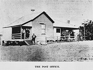
However, in 1878, the name was changed to Isisford. This name came from the nearby Isis Downs property and a shallow crossing (a ford) on the Barcoo River. As the farming industry grew, so did the town. By 1881, Isisford had a post office and a telegraph line.
Schools and Buildings
Isisford Private School opened in the 1870s. It later became Isisford Provisional School in 1881, and then Isisford State School. It changed back and forth a few times but has been Isisford State School since 1894.
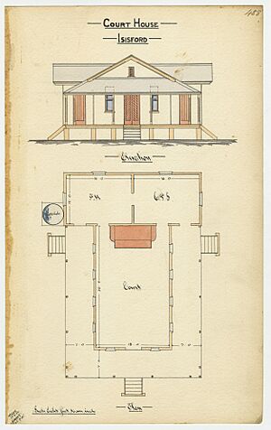
The Queensland Government built a court house in Isisford. It was finished in November 1885.
Modern Milestones
In April 1910, Isisford made history! It became the first town in Australia to have mail delivered by a motor vehicle. This mail service ran from Ilfracombe, which is 90 kilometers (56 miles) away. There's a special plaque at the post office to remember this event.
Isisford Convent School was opened in 1950 by the Presentation Sisters but closed in 1970.
Discovering Ancient Life
In the mid-1990s, an amazing discovery was made near Isisford. Fossils of an ancient crocodile-like animal were found in a dry creek. This extinct animal was named Isisfordia after the town. The town's former Deputy Mayor, Ian Duncan, found these important fossils!
In 2021, a new area called Yaraka was officially created around the town of Yaraka. This land used to be part of Isisford.
Who Lives in Isisford?
In 2011, Isisford and the areas around it had a population of 262 people. In both 2016 and 2021, the population of Isisford was 218 people. The number of people living here has never gone above 300.
Important Places in Isisford
Isisford has some places that are important for their history. These are called heritage-listed sites:
- Old Isisford District Hospital, located at 6 St Agnes Street.
- Isis Downs Woolshed, found on the Isisford-Blackall Road.
Learning in Isisford
Isisford State School is a primary school for students from Prep to Year 6. It's located at 14 St Helena Street. In 2018, the school had 9 students.
There isn't a high school in Isisford. Older students usually attend secondary schools in Longreach or Blackall. Some students might also use distance education (learning from home) or go to a boarding school.
Town Facilities
Isisford has a public library at 20 St Mary Street. It's run by the Longreach Regional Council.
The town also has a swimming pool, which is great for hot days. There's also a visitor information centre where you can learn more about the area.
 | Lonnie Johnson |
 | Granville Woods |
 | Lewis Howard Latimer |
 | James West |


