Yaraka facts for kids
Quick facts for kids YarakaQueensland |
|||||||||||||||
|---|---|---|---|---|---|---|---|---|---|---|---|---|---|---|---|

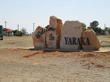
Welcome to Yaraka sign
|
|||||||||||||||
| Established | 1917 | ||||||||||||||
| Postcode(s) | 4731 | ||||||||||||||
| Elevation | 210 m (689 ft) | ||||||||||||||
| Time zone | AEST (UTC+10:00) | ||||||||||||||
| Location |
|
||||||||||||||
| LGA(s) | Longreach Region | ||||||||||||||
| State electorate(s) | Gregory | ||||||||||||||
| Federal Division(s) | Maranoa | ||||||||||||||
|
|||||||||||||||
Yaraka is a small town and area in the Longreach Region of Queensland, Australia. It is a rural place, meaning it is mostly countryside with farms. Until 2021, Yaraka was part of a larger area called Isisford.
Contents
Exploring Yaraka's Location
Yaraka is located in Central West Queensland, Australia. It is about 220 kilometers (137 miles) south of Longreach. It is also 165 kilometers (103 miles) west of Blackall. The town of Isisford is about 100 kilometers (62 miles) north of Yaraka.
What the Land Looks Like
The area around Yaraka is mostly open land with special "Mitchell grass downs." This type of land is great for grazing animals like sheep and cattle. The Grey Range is also nearby. This area has rocky hills, spiky spinifex grass, and mulga trees.
Mountains Around Yaraka
Yaraka is surrounded by several mountains and hills. These include:
- Boundary Point (402 meters or 1,319 feet high)
- Merry Peaks (368 meters or 1,207 feet high)
- Mount Brookes (379 meters or 1,243 feet high)
- Mount Margaret (356 meters or 1,168 feet high)
- Mount Remarkable (320 meters or 1,050 feet high)
- Mount Slowcombe (360 meters or 1,181 feet high)
- Sun Down Hill (320 meters or 1,050 feet high)
Yaraka's Past: A Look Back

The first European explorer to travel through this area was Edmund Kennedy in 1847. By 1860, farmers began to settle here. They started raising sheep and cattle.
The Railway Arrives
In 1910, the Queensland Government decided to build a railway line in Western Queensland. This line was meant to help the farming industry. However, only a small part of the planned line was built. Yaraka became the very end of this Yaraka branch railway line.
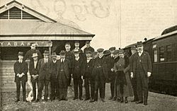
The town of Yaraka officially started when the train line from Emmet opened in April 1917. The railway department named the station Yaraka. They said it was an Aboriginal word meaning "white spear grass" or referring to "button grass."
Early Days and Growth
Yaraka State School opened its doors on March 5, 1920. The town grew for about 20 years. In the 1930s, around 100 people lived there. A journalist visited in 1932 and described Yaraka as a small, isolated place. He noted that people living there needed a lot of courage.
In 1932, a strong storm hit Yaraka. It blew the local Church of England building off its foundation. Three houses also lost their roofs.
The Railway's Importance
In the 1950s, the Yaraka railway station became very important for moving cattle. In November 1953, over 5,442 cattle were sent from Yaraka. This was the most cattle handled there since the line opened in 1917.
The train line officially closed on October 14, 2005, and was later taken apart.
Yaraka Today
Today, Yaraka is known as one of Queensland's "vanishing towns." Its population has been getting smaller. The school closed in 2009 because there were not enough students.
In 2014, the school building was given to the local community. In 2016, the community reopened the school. Children now study there using Longreach School of Distance Education programs. A governess (a private teacher) helps them locally.
In 1998, famous country singer Lee Kernaghan performed in Yaraka. About 3,000 people came to his concert. The money raised helped buy a defibrillator for the medical clinic and supported the school.
On September 10, 2021, a new area called Yaraka was officially created. This separated it from the larger Isisford area. This change helped avoid confusion and brought back historical connections.
Learning in Yaraka
There are no schools directly in Yaraka. The closest primary school is Isisford State School, which is 102 kilometers (63 miles) north in Isisford. For high school, the nearest option is Blackall State School, 162 kilometers (101 miles) north-east in Blackall.
Many children in Yaraka use Distance education to learn from home. Some also go to boarding schools. The old Yaraka State School building is now used for children doing distance education. They can study together there with help from a governess.
What Yaraka Offers
Yaraka has a hotel where visitors can stay. There is also an Anglican church on Quilp Street that holds services sometimes.
The Longreach Region Council provides other useful places for the community. These include a community hall, showgrounds, a swimming pool, tennis courts, and a golf course.
Fun Things to Do in Yaraka
Mount Slowcombe Lookout
Mount Slowcombe Lookout is a great spot to visit. It is located off the Emmet Yaraka Road. People say it is "an ideal place to enjoy the stunning outback sunset or the glorious colors of a sunrise." From the lookout, you can see the Yanyang Range, Mount Brookes, and Fort Douglas. The colors of these mountains change with the light. There is a paved road to the top, along with an electric barbecue and picnic area. Nearby waterholes are home to many birds and other wildlife.
Historic Sites
- Magee's Shanty: This is a historic site mentioned in Banjo Paterson's famous poem "A Bush Christening."
- Cobb & Co Pub Ruins: You can also see the old ruins of a Cobb & Co pub.
- Richard Magoffin's Grave: There is a lonely grave of a gold miner named Richard Magoffin, who died in 1885.
Yaraka Opal Field
The Yaraka Opal Field is an area where people mine for opals. It includes mines within and west of the Macedon Range, like Harlequin and Mount Tighe. This area is known for beautiful opal patterns and different types of opal found at various levels. Some of the mines here are Spur, Polykettle, Cockatoo, and Pretty Gully.
National Parks Nearby
There are two national parks close to Yaraka:
- Welford National Park: This park is famous for its golden-green spinifex grass, white-barked ghost gum trees, and red sand dunes.
- Idalia National Park: A highlight of this park is its thick Mulga woodlands and amazing views.
Other Activities
Visitors to Yaraka can also enjoy fishing, exploring the area, watching wildlife, and learning about geology. There are free caravan sites with water and electricity near the Yaraka Community Hall for travelers.
Yaraka's Weather
Here are some facts about the weather in Yaraka:
- Summer Average (day): The temperature is usually between 35.8⁰C (96.4⁰F) and 37.1⁰C (98.8⁰F).
- Summer Average (night): The temperature is usually between 21.9⁰C (71.4⁰F) and 22.9⁰C (73.2⁰F).
- Winter Average (day): The temperature is usually between 22.5⁰C (72.5⁰F) and 25.1⁰C (77.2⁰F).
- Winter Average (night): The temperature is usually between 6.5⁰C (43.7⁰F) and 7.9⁰C (46.2⁰F).
- Average Annual Rainfall: Yaraka gets about 451 millimeters (17.7 inches) of rain each year.
 | Sharif Bey |
 | Hale Woodruff |
 | Richmond Barthé |
 | Purvis Young |


