Eromanga, Queensland facts for kids
Quick facts for kids EromangaQueensland |
|||||||||||||||
|---|---|---|---|---|---|---|---|---|---|---|---|---|---|---|---|

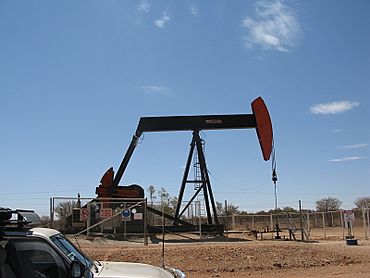
Oil pumpjack near Eromanga
|
|||||||||||||||
| Population | 98 (2021 census) | ||||||||||||||
| • Density | 0.003469/km2 (0.00898/sq mi) | ||||||||||||||
| Postcode(s) | 4480 | ||||||||||||||
| Area | 28,252.0 km2 (10,908.2 sq mi) | ||||||||||||||
| Time zone | AEST (UTC+10:00) | ||||||||||||||
| Location |
|
||||||||||||||
| LGA(s) | Shire of Quilpie | ||||||||||||||
| County | Gordon | ||||||||||||||
| State electorate(s) | Warrego | ||||||||||||||
| Federal Division(s) | Maranoa | ||||||||||||||
|
|||||||||||||||
Eromanga is a small town in the Australian outback, located in Queensland. It is part of the Shire of Quilpie. In 2021, only 98 people lived there, making it a very tiny community.
Contents
Geography of Eromanga
Eromanga sits on the edge of an ancient sea. This sea, called the Eromanga Inland Sea, covered this area millions of years ago. Today, the region is known for its many oil wells and opal mines.
Dinosaurs and Fossils
Many amazing dinosaur fossils have been found near Eromanga. These finds include Australia's largest dinosaur, a huge plant-eating titanosaur. This makes Eromanga a very exciting place for scientists who study dinosaurs. The area is also the traditional land of the Ngandangara people.
Farthest from the Ocean?
Some people say Eromanga is the town farthest from any ocean in Australia. However, this claim is not entirely true. Other places in Australia could also be considered very far from the coast.
History of Eromanga
The name Eromanga has been used since about 1860. It is believed to come from an Aboriginal word. This word might mean "hot gale plain" or "windy plain." The exact language or dialect is not known.
Post Office and Schools
Eromanga got its first post office in 1902. Before that, a smaller "receiving office" opened in 1892.
The town has had a few schools over the years. Eromanga Provisional School first opened in 1897. It closed and reopened several times. The school finally reopened in 1990 and has been open since then.
Local Properties
One important property in Eromanga is Monler Station. It was first written about in 1928 by Keith Pegler. This farm is now run by the third generation of the Pegler family. It is located about 11 kilometres south of the town.
Monler Station started as a sheep and cattle farm. The family has faced many challenges over the years. These include natural disasters like droughts and floods. For example, in 2019, the area went over 200 days without much rain.
Economy in Eromanga
Eromanga has a special oil refinery called the Eromanga Refinery. This refinery makes fuel especially for mining equipment.
Farming is also a big part of the local economy. Many early settlers came to Eromanga in the 1860s. They started farms raising cattle and sheep.
Education in Eromanga
Eromanga State School is a primary school for children from early childhood to Year 6. It is located on Donald Street.
The school is quite small. Between 2010 and 2013, it had only 5 or 6 students. Each student had their own learning plan. In 2018, there were 6 students with two teachers.
There are no high schools in Eromanga or nearby. Older students can learn through distance education. They can also go to a boarding school in another town.
Amenities
The Eromanga branch of the Queensland Country Women's Association has its rooms in town. You can find them on the corner of Deacon and Donald Streets.
 | Sharif Bey |
 | Hale Woodruff |
 | Richmond Barthé |
 | Purvis Young |


