
Sweet Grass Hills facts for kids
Quick facts for kids Sweet Grass Hills |
|
|---|---|

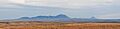
Sweetgrass Hills in Montana from Red Rock Coulee, Alberta
|
|
| Highest point | |
| Elevation | 6,983 ft (2,128 m) |
| Geography | |

Sweet Grass Hills
Location in Montana
|
|
| Country | United States |
| State | Montana |
The Sweet Grass Hills are a small group of low mountains in Montana, USA. They rise more than 3,000 feet above the flat plains around them. These hills are located southwest of Whitlash, Montana in Liberty and Toole County, Montana.
The tallest point in the hills is West Butte, which is 6,983 feet (2,128 meters) high. You can easily see these mountains from nearby roads like US Highway 2 and I-15. On clear days, they can even be seen from as far north as Alberta in Canada. Other important peaks in the group include Gold Butte (6,512 feet), East Butte (6,958 feet), and Mount Lebanon (5,807 feet).
The Sweet Grass Hills are a great example of "island ranges." These are mountains that stand alone, surrounded by flat plains. They are not connected to larger mountain chains like the Rocky Mountains. These island ranges are special because they are "biological hotspots." This means they have more types of plants and animals than the prairie lands below them.
Contents
How the Sweet Grass Hills Were Formed

The Sweet Grass Hills were formed a very long time ago, during the early Paleogene period. This was about 66 to 23 million years ago. Geologists, who study rocks and the Earth, call these formations "stocks."
What are Geological Stocks?
Stocks are created when hot, melted rock, called magma, pushes up from deep inside the Earth. This magma does not reach the surface. Instead, it cools and hardens underground. Over millions of years, the softer rock layers above these hardened magma areas wear away due to wind and water. This process, called erosion, leaves the harder, older rock exposed as mountains.
Climate and Plant Life
The upper parts of the Sweet Grass Hills were not covered by ice during the last ice age. They stood tall above the huge ice sheets that covered the surrounding area. Because the hills are higher than the plains, they have cooler temperatures and get more rain and snow. This allows forests to grow on their slopes. These forests are mostly made up of Douglas fir trees.
Cultural Importance of the Sweet Grass Hills
The Sweet Grass Hills are a very important and sacred site for the Blackfoot people. The Blackfoot are an aboriginal group whose lands are on both sides of the Canada–United States border.
Historical Events and Treaties
In 1872, the Sweet Grass Hills were the location of a battle between Native people and wolf hunters. Later, in 1887, an important agreement called the Sweetgrass Hills Treaty was signed here. This treaty was between the Blackfeet people and the United States government. Through this agreement, the Blackfeet gave up a large amount of land, about 17.5 million acres, to the U.S. government. The remaining 6 million acres were divided into three separate reservations for the Blackfeet, Fort Belknap, and Fort Peck tribes. The U.S. Congress officially approved this treaty in 1888.
Protecting the Hills
Because of their special history and natural beauty, the Sweet Grass Hills were listed as one of America's Most Endangered Places in 1993. This listing helps to bring attention to places that need protection. In 1995, a company called Manhattan Minerals made claims to dig for minerals in the hills. This shows the ongoing challenges of protecting sacred and natural areas.
Images for kids
-
West face Sweet Grass Hills from Sunburst, Montana on October 27, 2016
