
Sydenham, New Zealand facts for kids
Quick facts for kids
Sydenham
|
|
|---|---|
|
Suburb
|
|

The historic Sydenham Post Office and the Sydenham Heritage Church prior to the 2011 Christchurch earthquake
|
|

Sydenham
Location in New Zealand
|
|
| Country | New Zealand |
| Local authority | Christchurch |
| Electoral ward |
|
| Area | |
| • Land | 274 ha (677 acre) |
| Population
(June 2023)
|
|
| • Total | 6,840 |
|
|
||
Sydenham is a busy suburb located in Christchurch, New Zealand. It's about two kilometres south of the city centre, right on Colombo Street, which is a main road. Sydenham is a mix of homes, shops, and light industries.
Contents
History of Sydenham
Sydenham has been growing since the first European settlers arrived in Christchurch. At first, it was part of other areas, not its own place. The name "Sydenham" came from a shop called "Sydenham House," owned by Charles Prince. He named his shop after a town in England.
In 1876, the area grew enough to form its own local government, called a borough council. A surveyor named Charles Allison suggested naming it Sydenham after the shop. Everyone agreed, and the Sydenham Borough Council was created. The first mayor, George Booth, was elected in 1877.
Sydenham quickly became a very large and important borough. By 1902, its population had more than doubled. It had about 2,500 buildings and many kilometres of roads with gas lamps for lighting. On March 31, 1903, Sydenham joined the City of Christchurch and became a suburb. At that time, it already had its own swimming pools, fire station, cemetery, and parks.
The shopping area on Colombo Street was badly damaged by the 2010 Christchurch earthquake and the 2011 Christchurch earthquake. Many buildings had to be taken down. After the earthquakes, the Christchurch City Council made a plan in 2012 to help Sydenham rebuild and grow again.
By 2013, there were around 800 businesses in Sydenham, employing about 5,000 people. This business area was even given a nickname, "SoMo," by Lonely Planet in 2012. It also started calling itself the "Sydenham Quarter" as part of the rebuilding plan.
In 2015, the New Zealand Government bought the old Sydenham school site. This land was then sold to a company that built 76 new homes there, calling the new neighbourhood "350 Colombo."
Where is Sydenham Located?
Sydenham is very close to the centre of Christchurch. It's separated from the main city area by the South Island Main Trunk Railway and Moorhouse Avenue. State Highway 76, a major road, goes right through Sydenham. It then connects to the Christchurch Southern Motorway in the nearby suburb of Spreydon.
To the south of Sydenham, you'll find suburbs like Somerfield, Beckenham, and Cashmere, which are at the bottom of the Port Hills. To the east, the Ōpāwaho / Heathcote River separates Sydenham from St Martins. Waltham Road separates it from Waltham.
People of Sydenham
Sydenham is made up of different areas. Sydenham Central is mostly for businesses and light industries. Sydenham West, North, and South are mainly where people live.
In 2018, the residential parts of Sydenham had a population of 6,105 people. This was an increase from previous years, showing the area is growing. There were 2,583 households, with a nearly equal number of males and females. About 13% of the people were under 15 years old.
The people living in Sydenham come from many different backgrounds. About 74% are European/Pākehā, 9% are Māori, 4.4% are Pasifika, and 17.4% are Asian. Many people living in Sydenham were born overseas, showing its diverse community.
When asked about their beliefs, about half of the people said they had no religion. Many others were Christian, and smaller numbers followed other religions like Hindu, Muslim, or Buddhist faiths.
Historic Buildings in Sydenham
Sydenham has several old buildings that are protected because of their history by Heritage New Zealand. Sadly, some of these buildings were damaged or lost during the 2011 Christchurch earthquake.
The New Zealand Loan and Mercantile Woolstore on Durham Street is a very important historic building. The Sydenham Post Office and the Sydenham Heritage Church used to mark the entrance to the shopping area on Colombo Street. However, the church was taken down after the earthquake, which caused some debate.
Other notable buildings include the Nazareth House Chapel, which is part of a retirement village. There are also the Blackheath Place terrace houses, which are brick homes that are quite rare in New Zealand. You can also find three registered historic cottages on Shelley and Tennyson Streets.
Sydenham's Economy
The Colombo Shopping Centre

The Colombo is a popular shopping centre in Sydenham. It has 44 different shops and businesses, including the Academy Gold Cinema. In 2020, a well-known New Zealand retail chain, Smiths City, moved its main store to The Colombo.
Restaurants and Food
Colombo Street in Sydenham is a great place to find many different restaurants and takeaway food places.
Art District
Sydenham has a lively art scene. There are at least five art galleries in the area, such as Chambers Art Gallery, Jonathan Smart Gallery, and Fiksate Studio & Gallery. Many buildings also feature colourful street art, and public art events are often held here. Artworks have even been placed on Colombo Street to welcome people into Sydenham.
Light Industry
North of Brougham Street, you'll find many businesses involved in light industry. This means they make or process goods, but not on a very large scale.
Sports in Sydenham

Sydenham Park is a large public green space where many sports are played. It's the home ground for several local sports clubs:
- Sydenham Cricket Club
- Sydenham Lawn Bowls Club
- Sydenham Hockey Club
- Sydenham Rugby Club
These clubs have helped train many talented athletes who went on to play for New Zealand national teams. Famous players include Blair Hartland, Lee Germon, Rob Nicol, Chad Bowes, and Stephen Fleming for cricket. Gary Lawson played for the national bowls team, John Radovonich for hockey, and Charlie Oliver for rugby. Even Ben Stokes, a famous English cricketer, spent time training with the Sydenham Cricket Club in 2020.
Christchurch South Police Station

The Christchurch South Police Station is located on Colombo Street. It opened in 2009 and cost $7.5 million to build. Before this, Sydenham had a police station on Stanley Street.
Education in Sydenham
Sydenham School was one of the first schools in the area. It opened in 1872 and was first known as Colombo Road School. The land for the school cost one hundred pounds, and building it cost another 862 pounds. By March 1873, nearly 400 children were enrolled! The school was renamed Sydenham School in 1880. At one point, it was the largest school in all of New Zealand. However, Sydenham School closed its doors in December 2000.
As of 2021, there are no primary or secondary schools located directly within the Sydenham suburb. Instead, students living in Sydenham attend schools in neighbouring areas. For example, Somerfield School serves students west of Colombo Street and south of Brougham Street. Waltham School serves students east of Colombo Street and south of Moorhouse Avenue. Addington School covers areas west of Colombo Street and north of Somerfield's zone. Beckenham School serves students east of Colombo Street and south of King and Huxley Streets.
Images for kids
-
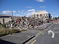
Sydenham Heritage Church after demolition, with the Post Office in the background
-
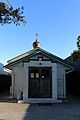
St Nicholas Russian Orthodox Church, Sydenham, Christchurch (October 2021)
-
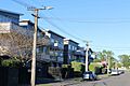
Hutcheson Street, a residential area of Sydenham, Christchurch (October 2021)
-
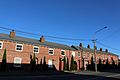
Blackheath terrace houses (built in 1876)
-
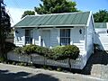
This historic cottage is typical of settler housing in Sydenham Christchurch. It was built in 1876 from totara.


