Syracuse, Utah facts for kids
Quick facts for kids
Syracuse, Utah
|
|
|---|---|

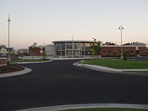
Syracuse City Municipal Center
|
|

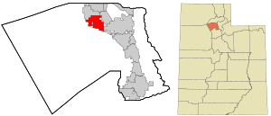
Location in Davis County and the state of Utah
|
|
| Country | United States |
| State | Utah |
| County | Davis |
| Settled | 1878 |
| Incorporated | September 3, 1935 |
| City | September 13, 1950 |
| Named for | Syracuse, New York |
| Government | |
| • Type | Mayor-council government |
| Area | |
| • Total | 10.18 sq mi (26.37 km2) |
| • Land | 10.18 sq mi (26.35 km2) |
| • Water | 0.01 sq mi (0.02 km2) |
| Elevation | 4,272 ft (1,302 m) |
| Population
(2010)
|
|
| • Total | 24,331 |
| • Density | 3,091.39/sq mi (1,193.63/km2) |
| Time zone | UTC-7 (Mountain (MST)) |
| • Summer (DST) | UTC-6 (MDT) |
| ZIP code |
84075
|
| Area codes | 385, 801 |
| FIPS code | 49-74810 |
| GNIS feature ID | 2412024 |
Syracuse is a city in Davis County, Utah, in the United States. It sits between the Great Salt Lake and Interstate 15. The city is about 30 miles (48 km) north of Salt Lake City. It is part of the larger Ogden–Clearfield area.
Syracuse has grown very quickly since the 1990s. In 2010, its population was 24,331 people. This was a huge increase of almost 160% since the year 2000. People started settling in this area in the mid-1800s. Syracuse officially became a city on September 3, 1935. Early settlers named the city after Syracuse, New York. That city was famous for making salt in the 1800s.
Contents
Where is Syracuse Located?
Syracuse is in the northern part of Davis County. It is on the eastern side of the Great Salt Lake. The city shares borders with other towns. To the north is West Point. To the northeast and east is Clearfield. To the southeast, it borders Layton.
A road called SR 127 connects Syracuse to Antelope Island State Park. This park is located in the Great Salt Lake. The United States Census Bureau says Syracuse covers about 10.18 square miles (26.37 square kilometers). Only a tiny part of this area is water.
Syracuse Weather
Syracuse has a climate that can be described in two ways. It is either a Mediterranean climate or a dry-summer continental climate. Summers are hot and mostly dry. Temperatures often reach 95°F (35°C). Some days can even hit 100°F (38°C).
Rain in summer comes from thunderstorms. These usually happen between late July and mid-September. This is when the monsoon season is strongest. The Pacific storm season runs from October to May. During this time, the city gets most of its rain and snow.
Snow usually starts in late October or early November. The last snow often falls in April. Winters are cool and snowy. The average high temperature in January is about 36°F (2°C). Syracuse gets about 39 inches (99 cm) of snow each year. The total rainfall is about 27.41 inches (69.6 cm) annually.
The coldest temperature ever recorded was -16°F (-27°C) on January 26, 1949. The hottest was 106°F (41°C) on July 14, 2002.
| Climate data for Syracuse, Utah (1981–2010 normals) | |||||||||||||
|---|---|---|---|---|---|---|---|---|---|---|---|---|---|
| Month | Jan | Feb | Mar | Apr | May | Jun | Jul | Aug | Sep | Oct | Nov | Dec | Year |
| Record high °F (°C) | 65 (18) |
68 (20) |
78 (26) |
87 (31) |
98 (37) |
102 (39) |
106 (41) |
102 (39) |
97 (36) |
93 (34) |
75 (24) |
66 (19) |
106 (41) |
| Mean daily maximum °F (°C) | 35.5 (1.9) |
42.5 (5.8) |
52.8 (11.6) |
61.3 (16.3) |
71.1 (21.7) |
82.3 (27.9) |
89.6 (32.0) |
88.5 (31.4) |
78.3 (25.7) |
66.8 (19.3) |
49.7 (9.8) |
37.5 (3.1) |
63.0 (17.2) |
| Mean daily minimum °F (°C) | 24.8 (−4.0) |
29.3 (−1.5) |
36.3 (2.4) |
43.1 (6.2) |
51.3 (10.7) |
60.1 (15.6) |
66.7 (19.3) |
66.1 (18.9) |
57.7 (14.3) |
45.5 (7.5) |
35.3 (1.8) |
26.5 (−3.1) |
45.2 (7.3) |
| Record low °F (°C) | −16 (−27) |
−11 (−24) |
3 (−16) |
17 (−8) |
21 (−6) |
33 (1) |
37 (3) |
34 (1) |
29 (−2) |
11 (−12) |
−12 (−24) |
−12 (−24) |
−16 (−27) |
| Average precipitation inches (mm) | 3.05 (77) |
2.50 (64) |
2.60 (66) |
2.50 (64) |
2.40 (61) |
1.40 (36) |
0.70 (18) |
0.80 (20) |
1.60 (41) |
1.80 (46) |
2.40 (61) |
2.75 (70) |
24.24 (616) |
| Average snowfall inches (cm) | 12.3 (31) |
7.5 (19) |
3.4 (8.6) |
1.4 (3.6) |
0.1 (0.25) |
0 (0) |
0 (0) |
0 (0) |
0 (0) |
0.5 (1.3) |
5.3 (13) |
9.4 (24) |
39.3 (100) |
| Average precipitation days (≥ 0.01-inch) | 8.3 | 13.8 | 14.3 | 14.0 | 14.5 | 8.1 | 6.9 | 7.0 | 8.0 | 8.4 | 9.7 | 11.8 | 124.8 |
| Average snowy days (≥ 0.1-inch) | 5.2 | 3.3 | 1.9 | 0.9 | 0 | 0 | 0 | 0 | 0 | 0.3 | 2.1 | 4.4 | 18.1 |
| Source: WeatherWX | |||||||||||||
People in Syracuse
| Historical population | |||
|---|---|---|---|
| Census | Pop. | %± | |
| 1890 | 299 | — | |
| 1900 | 299 | 0.0% | |
| 1910 | 553 | 84.9% | |
| 1920 | 629 | 13.7% | |
| 1930 | 890 | 41.5% | |
| 1940 | 732 | −17.8% | |
| 1950 | 837 | 14.3% | |
| 1960 | 1,061 | 26.8% | |
| 1970 | 1,843 | 73.7% | |
| 1980 | 3,702 | 100.9% | |
| 1990 | 4,658 | 25.8% | |
| 2000 | 9,398 | 101.8% | |
| 2010 | 24,331 | 158.9% | |
| 2020 | 32,141 | 32.1% | |
| U.S. Decennial Census | |||
In 2010, the city had 24,331 people living in 6,362 homes. The city was home to about 2,793 people per square mile (1,078 per square kilometer). Most people living in Syracuse were White (94.6%). Other groups included Asian (2.9%), African American (1.2%), and Native American (0.7%). About 6% of the population was Hispanic or Latino.
About 42% of homes in 2010 had children under 18 living there. Most homes (83.3% in 2000) were married couples living together. The average household had 3.81 people in 2010. The average family had 4.02 people.
The average age of people in Syracuse was 26.5 years in 2010. For every 100 females, there were about 102.56 males. The average income for a household in 2000 was $58,223. For families, it was $60,000. A small number of families (2.1% in 2000) lived below the poverty line.
Schools in Syracuse
Syracuse has several schools for students of all ages:
- Syracuse Elementary
- Bluff Ridge Elementary
- Cook Elementary
- Buffalo Point Elementary
- Syracuse Arts Academy (an elementary charter school)
- Syracuse Arts Academy Junior High (the middle school for the Arts Academy)
- Syracuse Jr. High School
- Syracuse High School
- Island View Residential Treatment Center
See also
 In Spanish: Syracuse (Utah) para niños
 | May Edward Chinn |
 | Rebecca Cole |
 | Alexa Canady |
 | Dorothy Lavinia Brown |

