Tabeguache Peak facts for kids
Quick facts for kids Tabeguache Peak |
|
|---|---|

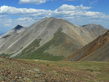
Tabeguache Peak viewed from the west
|
|
| Highest point | |
| Elevation | 14,162 ft (4,317 m) |
| Prominence | 455 ft (139 m) |
| Isolation | 0.75 mi (1.21 km) |
| Listing | Colorado Fourteener 25th |
| Geography | |
| Location | Chaffee County, Colorado, U.S. |
| Parent range | Sawatch Range |
| Topo map | USGS 7.5' topographic map Saint Elmo, Colorado |
| Climbing | |
| Easiest route | Hike |
Tabeguache Peak is a tall mountain in the state of Colorado, U.S.. It is known as a "fourteener" because its peak is over 14,000 feet (about 4,267 meters) high. Tabeguache Peak stands at 14,162 feet (4,317 meters) above sea level.
This mountain is very close to another, even taller peak called Mount Shavano. Mount Shavano is only about half a mile (1 kilometer) away. Tabeguache Peak is often seen as a close companion to Mount Shavano.
Where is Tabeguache Peak?
Tabeguache Peak is located in Chaffee County, in the south-central part of the Sawatch Range. This mountain range is famous for its many high peaks.
The peak is found within the San Isabel National Forest. This is a large area of protected land. It lies just east of the Continental Divide. The Continental Divide is like a giant line across North America. It separates the rivers that flow to the Pacific Ocean from those that flow to the Atlantic Ocean. Tabeguache Peak is also just west of the Arkansas River.
What Does the Name Mean?
The name "Tabeguache" comes from the Tabeguache band of the Utes. The Ute people are a Native American tribe.
The word "Tabaguache" means 'People of Sun Mountain'. This name comes from the Ute word "Tava," which means 'sun.' So, the mountain's name connects it to the sun and the Ute people.
People pronounce the name in a few ways. Some say "TAB-uh-wahch," while others say "tab-uh-wash." The accent is usually on the first part of the word.
Mountain Facts
- Elevation: 14,162 feet (4,317 meters)
- Location: Chaffee County, Colorado
- Mountain Range: Sawatch Range
- Easiest Way to Reach the Top: Hiking
 | George Robert Carruthers |
 | Patricia Bath |
 | Jan Ernst Matzeliger |
 | Alexander Miles |


