
Taitao Peninsula facts for kids
The Taitao Peninsula (in Spanish, Península de Taitao) is a piece of land that sticks out from the mainland of Chile towards the west. It's connected to Chile by a narrow strip of land called the Isthmus of Ofqui. Long ago, native people and early missionaries would carry their boats over this narrow land to get between the Moraleda Channel and the Gulf of Penas.

The peninsula is located in the Aysén del General Carlos Ibáñez del Campo Region. A part of it is inside the Laguna San Rafael National Park, which is a beautiful natural area. In the middle of the peninsula is a large body of water called Presidente Ríos Lake, covering about 352 square kilometers. A part of the peninsula that curves south is known as the Tres Montes Peninsula, and its southernmost tip is a cape with the same name.
In the 17th and 18th centuries, Spanish explorers and Jesuit missionaries often sailed south from the Chiloé Archipelago. They usually avoided sailing all the way around the Taitao Peninsula because it was difficult. Instead, they would cross the Isthmus of Ofqui by land to reach the Gulf of Penas.
In 1741, a ship called HMS Wager was trying to pass the Gulf of Penas when a big storm hit. The ship was wrecked near Wager Island. Some of the people who survived, including a man named John Byron, were helped by the Chono people. The Chono chief, Martín Olleta, guided them through Presidente Ríos Lake to Spanish settlements in the Chiloé Archipelago.
In 1946, a writer named Benjamín Subercaseaux visited the Taitao Peninsula. He reported seeing signs that made him believe the indigenous Chono people, who were known from history, might still be living there.
Because it's so hard to reach and very isolated, much of the Taitao Peninsula remains unexplored.
Contents
Plants of the Peninsula
The types of plants you find on the Taitao Peninsula change depending on where you are.
Western Plants
On the western edges of the peninsula, especially towards the Tres Montes Peninsula, you'll find a type of shrubland. This area has shrubs about 2 meters tall, including plants like Pilgerodendron uvifera and Nothofagus nitida. You might also see some wet, spongy areas called peatlands and occasional forests mixed in with the shrubs.
Central Forests
In the central parts of the peninsula, including the areas around Presidente Ríos Lake, there are forests filled with trees like Nothofagus betuloides and Drimys winteri.
Mountain Plants
The higher mountains on the peninsula are home to special cushion peatlands. These are areas where plants like Donatia fascicularis and Oreobolus obtusangulus grow in dense, low clumps that look like cushions.
Eastern Forests
Near San Rafael Lake in the east, you'll find a forest of Nothofagus betuloides trees. Underneath these trees, there's a layer of smaller plants called an understory. This includes plants like Desfontainia fulgens, Blechnum magellanicum, Fuchsia magellanica, and Raukaua laetevirens.
Geology of the Peninsula
The Taitao Peninsula is located near a very important spot called the Chile Triple Junction. This is where three huge pieces of the Earth's crust, called tectonic plates, meet: the Antarctic Plate, the South American Plate, and the Nazca Plate.

Special rock formations, like the Taitao ophiolite, are found here because of this triple junction. Over millions of years, a feature called the Chile Rise has been sliding underneath the South American Plate at the Taitao Peninsula. This process, called subduction, has caused three major collisions between the underwater mountain ridge and the continent, starting about 5 million years ago.
Images for kids
-
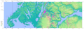
Península de Taitao: This map shows the Taitao Peninsula.
-
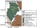
Geological map of the Peninsula
See also
 In Spanish: Península de Taitao para niños
