
Laguna San Rafael National Park facts for kids
Quick facts for kids Laguna San Rafael National Park |
|
|---|---|
|
IUCN Category II (National Park)
|
|

Northern Patagonian Ice Field
|
|
| Location | Aysén del General Carlos Ibáñez del Campo Region, Chile |
| Nearest city | Puerto Chacabuco |
| Area | 17,420 km2 (6,726 sq mi) |
| Established | 1959 |
| Governing body | Corporación Nacional Forestal |
Laguna San Rafael National Park is a huge park on the Pacific coast of southern Chile. It's named after the San Rafael Lagoon, which was formed as the San Rafael Glacier melted and moved back. This park was created in 1959. It covers a massive area of about 17,420 square kilometers (6,726 square miles). This includes a large part of the Northern Patagonian Ice Field. One of the most amazing sights in the park is a fjord (a long, narrow sea inlet) that stretches over 16 kilometers (10 miles).
Contents
History of Laguna San Rafael National Park

People from outside the local area first explored the Laguna San Rafael region in 1675. At that time, the San Rafael Glacier ended on land. It likely reached the lagoon again sometime between 1741 and 1766. Since then, it has been a "tidewater glacier." This means it ends in the water, where ice breaks off into the lagoon.
In 1979, UNESCO named the park a World Biosphere Reserve. This means it's a special place where nature is protected, and people try to find ways to live with and learn from the environment.
Geography and Landscapes
This park is home to some of the tallest Andes mountains in Patagonia. These include Monte San Valentín, Cerro Arenales, Cerro Hyades, and Cerro Pared Norte.
Many rivers flow through or near the park. The San Tadeo River is in the Isthmus of Ofqui. It flows into San Quintín Bay in the northern part of the Gulf of Penas. Other rivers bordering the park are the Baker River and the Exploradores River. The Témpanos River connects San Rafael Lagoon with the Gulf Elefantes, which is the southern part of Moraleda Channel.
Presidente Ríos Lake is a lake that sits on the border between the park and Las Guaitecas National Reserve.
Climate and Weather

The weather in Laguna San Rafael National Park can be very wet. At Cabo Raper, on the coast, the average rainfall each year is about 2,000 millimeters (79 inches). As you move eastward into the more sheltered areas, the rain increases.
At the Laguna San Rafael weather station, between 1981 and 1985, the average yearly rainfall was about 4,440 millimeters (175 inches). In the higher mountains, especially on the Northern Patagonian Ice Field, even more rain falls. It often comes as snow, with over 6,000 millimeters (236 inches) of precipitation each year.
Temperatures at Cabo Raper are mild. In January, the warmest month, the average high is around 14.3°C (57.7°F). In July, the coldest month, the average high is about 9.4°C (48.9°F).
Amazing Plants and Animals
As mentioned, the park is a World Biosphere Reserve by UNESCO. This means it's very important for protecting different kinds of life.
Bird Species
Many types of birds live in or visit the park. You might see black-browed albatrosses flying over the water. Other birds include great grebes, black-necked swans, and different kinds of cormorants.
Land and Sea Animals
The park is also home to many land and sea animals. On land, you might spot a South American gray fox or a South Andean deer. In the waters around the park, there are Chilean dolphins, South American sea lions, and marine otters. You might even see large southern elephant seals.
Sometimes, huge baleen whales swim into the Gulf of Penas. This gulf is thought to be a special place where the very rare Southern Right Whale might spend the winter or have its babies.
Images for kids
-
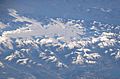
Northern Patagonian Ice Field
-
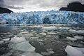
View of the glacier over the San Rafael Lake.
-
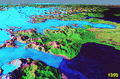
San Rafael Glacier retreat (foreground) between 1990 and 2000.
See also
 In Spanish: Parque nacional Laguna San Rafael para niños
