
Wager Island facts for kids

|
|

|
|

Wager Island
Location in Chile
|
|
| Geography | |
|---|---|
| Location | Capitán Prat Province, Aysén Region, Chile |
| Coordinates | 47°43′27″S 74°57′37″W / 47.72417°S 74.96028°W |
| Archipelago | Guayaneco Archipelago |
| Area | 105 km2 (41 sq mi) |
| Highest elevation | 586 m (1,923 ft) |
| Highest point | Monte Wager |
| Administration | |
Wager Island (which means Isla Wager in Spanish) is an island in a very distant part of western Patagonia. No one lives on the island. It is part of the Guayaneco Archipelago.
The island is about 1600 kilometers (about 1000 miles) south of Santiago, the capital city of Chile. Wager Island belongs to the Capitán Prat Province in the Aysén Region of Chile. It became famous because of the Wager Mutiny. This event happened in October 1741 after a British warship, HMS Wager, crashed there.
Contents
Island's Past: A Look at Wager Island's History
Early Visitors and Peoples
The Guayaneco Archipelago, where Wager Island is located, was likely a meeting place for different groups of native people. These groups traveled by canoe and lived both north and south of the islands. Experts believe it was a spot where friendly tribes who spoke different languages could meet.
European explorers started mapping this area after the Strait of Magellan was found in 1520. The first Europeans to meet the Chono people were members of an expedition led by Francisco de Ulloa in 1553. Later, in 1613, Jesuit priests from Chiloé reached these islands.
False stories about European towns near the Strait of Magellan made the Spanish send more expeditions. These included trips led by Bartolomé Gallardo in 1674–1675 and the Antonio de Vea expedition in 1675–1676.
During colonial times, northern tribes like the Chonos and Huilliche, along with the Spanish from Chiloé, called the sea-traveling people of the Wager Island area "Caucahue". They spoke a different language from the Chono people. Historians believe the Caucahue were actually ancient Kawésqar people.
The Shipwreck of HMS Wager

On September 18, 1740, the British warship HMS Wager left England. It was part of Commodore George Anson's fleet. The ship had 160 crew members, plus many sick soldiers and marines.
On May 14, 1741, the Wager got stuck in the Gulf of Penas, just south of the Taitao Peninsula. It then crashed on what we now call Wager Island. About 140 men survived the crash and made it to the island in small boats. But by the end of June, many of them had died from hunger, drowning, cold, and injuries.
After many difficult months, the remaining survivors left Wager Island in two groups. The first group, made up of 81 sailors who had rebelled (known as mutineers), left on October 13, 1741. Of these, 30 men reached Río Grande, Brazil, on January 28, 1742. One of them died soon after arriving.
A second group of 11 survivors and one Indian guide left Wager Island on March 6, 1742. Led by the Chono chief Martín Olleta, they traveled through Presidente Ríos Lake inside the Taitao Peninsula. This route helped them avoid the dangerous Tres Montes Peninsula on the coast.
From this second group, three survivors reached Chiloé Island, Chile, in early June 1742. They were Captain David Cheap, midshipman John Byron, and midshipman Alexander Campbell. Another survivor, Marine Lieutenant Thomas Hamilton, was rescued by a Spanish search party about three months later and brought to Chiloé Island. In total, only 36 men from the original ship returned alive to Britain.
What Happened to the Wreck?
From late 1742 to 1769, Spanish groups and local native people tried to recover items from the wreck of HMS Wager. A priest named Pedro Flores found about 100 kilograms (220 pounds) of iron in late 1742.
The first big effort to salvage the wreck was led by Mateo Abraham Evrard in 1743. They found many items, including:
- Ten iron cannons (six-pounders)
- Four bronze cannons (three-pounders)
- An anchor
- Over 100 cannonballs
- 1000 musket balls
- Three copper cooking pots
In 1779, Spanish missionaries Fray Benito Marín and Fray Julián Real found a small native village. It had four homes built on the beach near where the ship had crashed.
In 2006, the Scientific Exploration Society sent an expedition to find what was left of the wreck. They found a 5 square meter (54 square feet) piece of wooden hull planking in shallow water. This piece seemed to match how the Wager was built.
Island's Features: Geography of Wager Island

Wager Island is part of the Guayaneco Archipelago. It is located about 1600 kilometers (about 1000 miles) south of Santiago. This area is in the southern part of the Gulf of Penas in the southern Pacific Ocean.
The island is about 18 kilometers (11 miles) long from northwest to southeast and 10 kilometers (6 miles) wide. The Guayaneco Archipelago has two main islands: Byron Island, which is larger, and Wager Island, which is smaller.
Wager Island is separated from Byron Island by a passage called Paso Rundle. It is also separated from a small island called Islote San Pedro by Bahía Acosta. Wager Island and Islote San Pedro mark the northwestern end of the Messier Channel. The Larenas Peninsula forms the northeastern end of this channel.
There is a lighthouse on Islote San Pedro. The Messier Channel is a busy waterway. Large cargo ships and cruiseferries regularly travel through it.
Because Wager Island is located between 46° and 60° south of the equator, it is called a subantarctic island. During the last ice age, called the Llanquihue glaciation, huge glaciers covered the area. This forced the forests to move far north. As the climate warmed and the glaciers melted about 10,000 years ago, the region slowly became forested again. The melting of the ice was mostly complete around 14,000 years ago.
Today, Wager Island has many high areas and deep valleys. It also has many steep cliffs and points of land. Important peaks include Monte Anson, which is 377 meters (1,237 feet) high, and Monte Wager, which is 586 meters (1,923 feet) high. The lower parts of these mountains are covered with Magellanic subpolar forests.
The closest village is Caleta Tortel, which is about 107 kilometers (66 miles) to the east. The nearest airport is Caleta Tortel Airport. The next closest village is Villa Puerto Edén, about 165 kilometers (103 miles) to the south. Villa Puerto Edén is one of the most remote villages in southern Chile.
Island's Foundation: Geology of Wager Island
Wager Island is one of many islands and deep bays that are left over from a coastal mountain range that is now mostly underwater. The island was formed by volcanic activity during the Tertiary period. It was created by the same geological forces that formed the Chilean Coast Range and the Andes mountains.
The Liquiñe-Ofqui Fault system, a major geological fault that is still active with earthquakes, passes near the southern coast of Wager Island.
Three tectonic plates meet near the Taitao Peninsula at a spot called the Chile Triple Junction (CTJ). These plates are the Antarctica, South America, and Nazca plates. The Nazca and Antarctic plates are moving east, while the South American plate is moving west. This movement has caused the western edge of the South American plate to sink, creating the many islands we see there today.
When the Chile Ridge (a mid-ocean ridge) slid under the South American plate at the CTJ, it caused three collisions between the ridge and the continent. This started about 5 million years ago.
During the Llanquihue glaciation (the last ice age), glaciers covered the Guayaneco Archipelago. These glaciers carved deep valleys into the islands. Today, these valleys are deep channels like the Messier Channel and the Fallos Channel, and fjords.
Life on the Island: Flora and Fauna
Wager Island is part of a natural area called the Magellanic subpolar forests. This is a type of temperate broadleaf and mixed forests found in the neotropical realm. Because of its cold climate and recent ice age history, there isn't a huge variety of plants and animals on the island.
The island's environment has cool temperatures, lots of rain, strong winds, and rocky ground with thin soil that doesn't drain well. Because of this, most of the land is covered in Magellanic moorland, peatlands, and bogs. These areas are made up of mosses, grasses, cushion plants, and small shrubs. Depending on how you classify it, Magellanic moorland can be seen as either tundra or heathland.
Images for kids
-
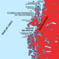
An old map of the region.
-
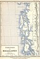
A map of the Magallanes Territory from 1895.
-
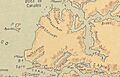
The Larenas Peninsula, near Wager Island.
-
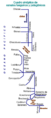
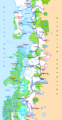
A map showing the channels of Chile.
-
The Carretera Austral, a famous road in Chile.
-
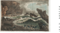
An 1809 painting of the HMS Wager shipwreck.
-
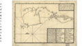
An 18th-century Spanish map of the Gulf of Penas, showing efforts to salvage the Wager.
-
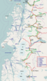
A map of the Aysén Region, showing rivers and cities.


.png)
See also
 In Spanish: Isla Wager para niños
- Fjords and channels of Chile
- George Anson's voyage around the world
- List of islands of Chile
- The Unknown Shore
