Tortel facts for kids
Quick facts for kids
Tortel
|
||||
|---|---|---|---|---|

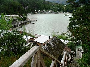
Wooden walkways in Caleta Tortel
|
||||
|
||||
| Country | Chile | |||
| Region | Aisén | |||
| Province | Capitán Prat | |||
| Seat | Caleta Tortel | |||
| Government | ||||
| • Type | Municipality | |||
| Area | ||||
| • Total | 19,930.6 km2 (7,695.2 sq mi) | |||
| Elevation | 7 m (23 ft) | |||
| Population
(2012 Census)
|
||||
| • Total | 487 | |||
| • Density | 0.024435/km2 (0.06329/sq mi) | |||
| • Urban | 0 | |||
| • Rural | 507 | |||
| Sex | ||||
| • Men | 322 | |||
| • Women | 185 | |||
| Time zone | UTC−04:00 (CLT) | |||
| • Summer (DST) | UTC−03:00 (CLST) | |||
| Area code(s) | 56 + 67 | |||
| Website | www.tortel.cl | |||
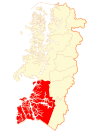
Tortel is a special area in Chile, located where the Baker River and Pascua River meet the Pacific Ocean. It sits between two huge ice fields: the Northern and Southern Patagonian Ice Field. This area is part of the Capitán Prat Province in the Aysén Region. The main town and where the local government works is called Caleta Tortel.
People and Population in Tortel
According to a count done in 2002, the Tortel area is very large, about 19,930 square kilometers. It has 507 people living there. Most of the people (322) are men, and 185 are women. This means Tortel is a completely rural area, with no big cities. The number of people living here grew by 13% between 1992 and 2002.
How Tortel is Governed
Tortel is a "commune," which is like a local district in Chile. It's managed by a group called the municipal council. The leader of this council is an "alcalde" (mayor), who is chosen by the people every four years. From 2008 to 2012, the mayor was Bernardo López Sierra.
Amazing Places to See in Tortel
The Tortel area is one of the most distant places in southern Chile. Its beautiful, untouched nature is a big reason why people visit. Here are some of its main attractions:
Caleta Tortel: The Wooden Walkway Town
Caleta Tortel is a small town known for its lumber industry. What makes it special are the many wooden walkways built by the people who live there. These walkways stretch for several kilometers around the town's cove. Without them, it would be very hard to move between houses, as the area has thick plants and steep hills. These walkways are now a key part of the town's culture and a popular spot for visitors.
Laguna San Rafael National Park: Glaciers and Fjords
Laguna San Rafael National Park is on the Pacific coast of southern Chile. It's famous for the San Rafael Lagoon, which was formed as the San Rafael Glacier moved back. This park was created in 1959 and covers a huge area of 17,420 square kilometers. It includes part of the Northern Patagonian Ice Field. One of the park's biggest draws is a fjord that is more than 16 kilometers long.
Southern Patagonian Ice Field: A Giant Ice World
The Southern Patagonian Ice Field is located in the Andes mountains between Argentina and Chile. It is the second-largest continuous ice field outside of the North and South Poles! This massive ice field is what's left of a much larger ice sheet that covered all of southern Chile during the last ice age.
Katalalixar National Reserve: Wild Nature
Katalalixar National Reserve is a natural protected area found among islands between the two large Patagonian ice fields. This reserve was created in 1983 and does not have any buildings or facilities. It covers about 6,245 square kilometers and is known for having more different types of plants and animals than other parts of southern Chile.
Bernardo O'Higgins National Park: Chile's Largest Park
Bernardo O'Higgins National Park is the biggest protected area in Chile, covering about 35,259 square kilometers. It is named after General Bernardo O'Higgins, who was the first leader of Chile. This park is managed by Chile's National Forest Corporation. It shares borders with other famous parks like Los Glaciares National Park in Argentina and Torres del Paine National Park in Chile.
Error: no page names specified (help). In Spanish: Tortel para niños
 | Bayard Rustin |
 | Jeannette Carter |
 | Jeremiah A. Brown |


