
Fjords and channels of Chile facts for kids
The southern coast of Chile has many amazing fjords and channel-like waterways, stretching from Cape Horn (way down south at 55° S) all the way up to the Reloncaví Estuary (42° S). Some of these fjords and channels are super important for ships, letting them reach busy ports like Punta Arenas, Puerto Chacabuco, and Puerto Natales.
Contents
A Look Back: History of the Fjords
Who Lived Here First? Indigenous Peoples
The very first people known to live in these fjords and channels were the Chono, Alacalufe, and Yaghan tribes. From north to south, they all shared a similar way of life: they traveled by canoe, hunting and gathering food. They also looked a bit alike, being shorter, having long heads, and "low faces." But even with these similarities, their languages were completely different!
The Chono people moved around the area from the Chiloé Archipelago down to 50° S. The Alacalufe lived from 46° S to the Strait of Magellan. This meant both groups often met in places like the Gulf of Penas and the Guayaneco Archipelago. The Yaghan people lived in a smaller area south of Tierra del Fuego.
Many people think the Chonos created most of the huge piles of ancient shell middens (called chonchales) found in the Chiloé Archipelago. However, this isn't fully proven. The Guaitecas Archipelago was the southernmost place where farming happened before Europeans arrived. A Spanish trip in 1557 even mentioned that potatoes were grown there!
Both the Chonos and Alacalufes used a special tree called Pilgerodendron uviferum. They used its wood for fires, boat oars, boats, and even their homes.
Spanish Explorers and the Chono Decline
Pedro de Valdivia originally wanted to take control of all of southern South America, right down to the Strait of Magellan (53° S). But he only managed to reach Reloncaví Sound (41°45' S). Later, in 1567, the Chiloé Archipelago (42°30' S) was conquered. After that, the Spanish Empire stopped expanding south.
The Spanish probably didn't have much reason to go further south. There weren't many native people, and their way of life was very different from the settled farming life the Spanish were used to. The tough weather in the Patagonian fjords and channels might have also stopped them. Even in Chiloé, the Spanish found it hard to adapt. Their plans to find gold and farm like they did in Spain didn't work out.
During the time of Spanish rule, the fjords and channels of Patagonia were first explored by the Spaniards. They had several reasons for exploring. They wanted to teach Christianity to the native people, stop other countries from taking land Spain claimed, learn more about the geography, and even search for a mythical city called the City of the Caesars.
False stories about European settlements near the Straits of Magellan made the Spanish organize the Antonio de Vea expedition in 1675–1676. This was the biggest expedition at the time. In 1792, the viceroy of Peru ordered more exploration of the Patagonian channels to find a way into the middle of Patagonia. José de Moraleda led this trip, visiting many important channels.
After the Chono people's numbers dropped in the 1700s, the area became known as "empty" among Chileans, similar to how eastern Patagonia was called a "desert." However, fishermen, lumberjacks, and hunters from Chiloé often visited and traveled through these islands in the 1800s. This shows that many areas explored by official trips were already known to the people of southern Chiloé, who went there for wood, fish, or hunting.
The Spanish didn't build much in the fjords and channels during colonial times. They had a few small chapels built in the early 1600s and a wooden fort in 1750. But all these buildings were left empty after only a few years.
The 1800s: Exploring and First Settlements
Chilean and European Explorers
In the early to mid-1800s, explorers like Robert FitzRoy and Francisco Hudson learned a lot more about these channels. When Hudson died in 1859, Francisco Vidal Gormaz continued the explorations. Then, Enrique Simpson took over in the 1870s. The channels south of the Isthmus of Ofqui were explored in great detail by Chilean government agent Hans Steffen in the late 1800s.
During his explorations, Vidal Gormaz became critical of the work done by Robert FitzRoy and Charles Darwin. He felt they hadn't fully understood how important the Patagonian islands were.
The Pilgerodendron Tree Boom
Felipe Westhoff, an immigrant from Germany and Lithuania, started a business cutting down Pilgerodendron uviferum trees from Ancud. In 1860, he founded Melinka in the Guaitecas Archipelago. This was the first lasting settlement in that area.
Chilean authorities gave Westhoff special rights to cut Pilgerodendron trees in the archipelago. They also made him a subdelegado marítimo, which gave him some duties and power over the area. But in reality, he couldn't really enforce laws or his rights. After Westhoff retired in the 1870s, Ciriaco Álvarez became the most important Pilgerodendron businessman.
Álvarez mainly exported poles and stacks for vine training to northern Chile and Peru. His business earned him the nickname "The King of Pilgerodendron" (El Rey del Ciprés). His work greatly helped the early economic development that connected the islands of Chiloé, Guaitecas, and Chonos.
Climate and Geography of the Fjords
It's very rare for the fjords to freeze in winter. But if they do, it usually happens in the inner parts of fjords where the water on the surface is mostly freshwater.
Ships often travel through the fjords and channels of Chile to avoid the rough seas and bad weather often found when sailing into the Pacific Ocean from the western end of the Strait of Magellan. Large, powerful mail ships usually go straight out to the open sea at Cape Pillar (at the western entrance of the Strait of Magellan). This saves them time. But ships with less engine power, where being on time isn't as important as avoiding danger, will find the Patagonian Channels the best route.
These channels generally have high, steep shores with countless peaks and headlands that look very similar. Their bold, rugged tops create a gloomy and grand look rarely seen anywhere else. The shores are usually very deep right next to them, and the channels are mostly open and clear. The few dangers that exist are usually marked by kelp (a type of seaweed). The tides are regular and not very strong, except in the English Narrows.
Some fjords, like the two mentioned above, were very useful for transport when western Patagonia was settled and became part of Chile. On the other hand, the fjords have acted like a natural wall, making it hard to travel by land from north to south in Chilean Patagonia.

Rules for Using the Waterways

All the water between Chile's baselines (imaginary lines drawn along the coast) and the actual shoreline are considered internal waters. This is based on a Chilean law from 1977 and the United Nations Convention on the Law of the Sea. This means Chile can make its own laws, control any use, and use any resources in these waters.
Foreign ships don't have the right to pass through internal waters. This lack of "innocent passage" is the main difference between internal waters and territorial waters. Chile does allow ships to use the main waterways under specific rules for the following routes (all names are in Spanish):
a) Throughout the Strait of Magellan: Punta Dúngenes - Primera Angostura - Segunda Angostura, Paso Nuevo -Paso Inglés - Paso Tortuoso - Paso Largo - Paso del Mar - Cabo Pilar (and back).
b) From Cabo Tamar to Isla San Pedro : Cabo Tamar - Canal Smyth - Canal Mayne or Canal Gray - Paso Victoria - Estrecho Collingwood - Paso Farquhar - Canal Sarmiento - Angostura Guías - Canal Inocentes - Canal Concepción - Paso Caffin - Canal Trinidad - either Pacific Ocean, (and back) or to continue Canal Wide - either (east route) Canal Icy - Canal Grappler or (west route) Canal Escape - Paso del Abismo or Paso Piloto Pardo - Canal Escape; then Paso del Indio - Angostura Inglesa - Canal Messier to Isla San Pedro, (and back) or from Cabo Ladrillero to Canal Concepción to inner channels (and back).
c) From Strait of Magellan to Puerto Natales or Puerto Bories: From Isla Brinkley - Seno Unión - Canal Morla Vicuña - Canal y angostura Kirke - Canal Valdés, Golfo Almirante Montt - Canal Señoret - Seno Última Esperanza - Puerto Natales - Puerto Bories (and back).
d) From Strait of Magellan to Puerto Williams: From Islote Anxious - Canal Magdalena - Canal Cockburn - Paso Brecknock or Canal Ocasión - Canal Unión - Paso Occidental - Paso Norte - Canal Ballenero- Canal O'Brien - Paso Timbales - Brazo noroeste del Canal Beagle - Canal Beagle - Puerto Williams (and back).(Chilean ships can use Paso Aguirre).
e) From Puerto Williams to Cabo de Hornos: Canal Beagle - Paso Picton - Paso Richmond - to Cabo de Hornos (and back).
f) To the East Beagle Channel: Ships coming from east can access through the eastern mouth, northeast of Isla Nueva or through the Pasos Richmond and Picton.
g) To Seno Otway and Seno Skyring: From Isla Carlos III - Canal Jerónimo - Seno Otway - Canal Fitz-Roy - Seno Skyring to Bahía Mina Elena (and back).
h) To Isla Guarello: From Isla Inocentes - Canal Concepción - Canal Oeste - Seno Contreras - Bahía Corbeta Papudo in Isla Guarello, (and back), or from Bahía Corbeta Papudo in Isla Guarello - Seno Contreras - Paso Metalero (and back).
i) Throughout Chonos Archipelago:
- From Isla Inchemó - Bahía Anna Pink - Boca Wickham - Canal Pulluche - Canal Chacabuco - Canal Errázuriz - Canal Moraleda until Gulf of Corcovado and Boca del Guafo (and back) or
- From Isla Inchemó - Bahía Anna Pink - Boca Wickham - Canal Pulluche - Canal Utarupa - Canal Darwin -Canal Moraleda to Gulf of Corcovado and Boca del Guafo (and back) or
- From Isla Auchilú, - Bahía Darwin - Canal Darwin - Canal Moraleda to Gulf of Corcovado and Boca del Guafo (and back) or
- From Bahía Adventure - Isla Liebre - Canal Niñualac - Canal Moraleda to Gulf of Corcovado and Boca del Guafo (and back).
j) To Bahía Chacabuco: From Canal Moraleda - Paso del Medio or Canal Pilcomayo or Canal Ferronave - Seno Aysén to Bahía Chacabuco (and back).
k) To Laguna San Rafael:
- From Canal Moraleda - Paso Casma - Canal Costa - Estero Elefante - Paso Quesahuén - Golfo Elefantes and Río Témpanos - Laguna San Rafael (and back) or
- From Canal Moraleda - Canal Errázuriz - Paso Tres Cruces - Estero Elefantes - Paso Quesahuén - Golfo Elefantes and Río Témpanos - Laguna San Rafael (and back).
l) Through the Inner Channels of Chiloé: From Boca del Guafo or Golfo Corcovado to Puerto Montt or to Golfo de Coronados, (and back) throughout the inner Channels heading to ports and bays.
m) To Puerto Montt Through Canal de Chacao: From Golfo Coronados - Canal de Chacao - Golfo de Ancud - Canal Calbuco or Paso Queullín - Seno de Reloncaví - Paso Guar - Puerto Montt (and back).
Getting Around: Transportation
Since it's impossible to reach all parts of this region by road in Chile, people and goods have to travel by ship or airplane.
Ferry Routes

To move lots of people, vehicles, and cargo directly to islands and coastal areas, ferry boats are the best choice. Most of these ferries are basically cargo boats without fancy cruise-ship features, though they have improved their service. There are about 150 large ships sailing in the southern parts of Chile.
Cruise ships also travel between the main ports. A cruise here is considered an experience in itself because of the slow journey through this amazing landscape of narrow channels and lonely islands.
The Carretera Austral (a famous highway) requires using three ferries:
- A 30-minute trip about 45 kilometers (28 miles) south of Puerto Montt.
- A 5-hour trip from Hornopirén (110 kilometers or 68 miles south of Puerto Montt) to Caleta Gonzalo.
- A 50-minute trip from Puerto Yungay to Rio Bravo, which connects to the last 100 kilometers (62 miles) of the highway.
Except for Chiloé Island, this region doesn't have many people living in it. The main ports are: Puerto Montt, Quellón, Chaitén, Melinka, Puerto Chacabuco, Puyuguapi, Puerto Natales, Punta Arenas, Porvenir, and Puerto Williams.
South of Chiloé, there are also smaller ports like Villa Puerto Edén, Bahía Corbeta Papudo on Guarello Island, Puerto Bories, Puerto Navarino, Puerto Toro, and Caleta Eugenia.
The Isthmus of Ofqui Canal Project

In 1937, the Chilean Government wanted to create a direct path from the Moraleda Channel to the Messier Channel. This would let ships avoid going out into the open Pacific Ocean to go around the Taitao Peninsula. So, they ordered the building of a canal from the San Rafael Lagoon through the isthmus. This canal was planned to be 2,200 meters (about 1.4 miles) long, 17 meters (56 feet) wide, and 5 meters (16 feet) deep. The plan also included dredging (deepening) the Negro River for 25 kilometers (15.5 miles).
Work on the ground started in 1937, managed by the railways department of the Ministry of Public Works. The work continued until May 1943, when they ran out of money. The map on the right shows the Laguna San Rafael and the Golfo Elefantes, which are the southernmost part of the Moraleda Channel. The Golfo San Esteban can be seen as the northernmost part of the Messier Channel.
Chacao Channel Bridge Project
The Chacao Channel bridge, also known as the Chiloé Bicentennial Bridge, is a planned bridge that would connect Chiloé with mainland Chile. It would cross the Chacao Channel. This was one of several projects planned to celebrate Chile's 200th birthday in 2010. If it's built as a suspension bridge, it would be the largest such bridge in South America.
Major Fjords and Channels
From Chacao to Guafo

- Chacao Channel
- Leads to the Sea of Chiloé and Reloncaví Sound
- Settlement: Chacao
- Calbuco Channel
- Leads to
- Settlements:
- Comau Fjord
- Leads to
- Settlements:
- Dalcahue Channel
- Leads to
- Settlements:
- Hornopirén Channel
- Leads to the Hornopirén area
- Settlement: Hornopirén
- Piti Palena Fjord
- Leads to
- Settlement: Raúl Marin
- Apiao Channel
- Leads to
- Settlements:
- Paso Desertores
- Leads to
- Settlements:
- Reloncaví Estuary
- Leads to Puelo River, Todos los Santos Lake, and Vuriloche Pass
- Settlements: Canutillar, Cochamó
- Reñihué Fjord
- Leads to the Carretera Austral
- Settlement: Caleta Gonzalo
From Guaitecas to the Gulf of Penas

- Aysén Fjord
- Leads to the Coyhaique area
- Settlement: Puerto Chacabuco
- Baker Channel
- Leads to the Baker and Pascua River area
- Settlement: Caleta Tortel
- Estero Capquelan
- Leads to
- Settlements:
- Mitchell Fjord
- Leads to Villa O'Higgins and O'Higgins Lake
- Settlement: Puerto Yungay
- Darwin Channel (not to be confused with Darwin Sound)
- Leads to
- Settlements:
- Moraleda Channel
- Leads to northern Aysén Region
- Settlements:
- Puyuhuapi Channel
- Leads to Villa La Tapera
- Settlement: Puerto Cisnes
- Ventisquero Sound
- Leads to
- Settlements:
From Gulf of Penas to Straits of Magellan

- Messier Channel
- English Narrows
- Guía Narrows
- A safe sea-lane from Central Chile to Punta Arenas, Puerto Natales, and Tierra del Fuego
- Settlement: Villa Puerto Edén
- Concepción Channel
- Leads to
- Settlements:
- Wide Channel
- Leads to
- Settlements:
- Inocentes Channel
- Leads to
- Settlements:
- Sarmiento Channel
- A safe sea-lane from Central Chile to Punta Arenas, Puerto Natales, and Tierra del Fuego
- Settlements:
- Señoret Channel
- Leads to
- Settlements:
- Peel Fjord
- Leads to
- Settlements:
- Eyre Fjord
- Leads to
- Settlements:
- Fallos Channel
- Leads to
- Settlements:
- Trinidad Channel
- Leads to
- Settlements:
- Ladrillero Channel
- Leads to
- Settlements:
- Picton Channel
- Leads to
- Settlements:
- Covadonga Channel
- Leads to
- Settlements:
- Albatros Channel
- Leads to
- Settlements:
- Adalbert Channel
- Leads to
- Settlements:
- Esteban Channel
- Leads to
- Settlements:
Tierra del Fuego and Puerto Natales

- Nelson Strait (Chile)
- Leads to
- Settlements:
- Fjord of the Mountains
- Leads to
- Settlements:
- Smyth Channel
- A safe sea-lane from Central Chile to Punta Arenas, Puerto Natales, and Tierra del Fuego
- Settlements:
- Seno Última Esperanza
- Leads to
- Settlements:
- Eberhard Fjord
- Leads to
- Settlements:
- Agostini Fjord
- Leads to
- Settlements:
- Almirantazgo Fjord
- Leads to Cami Lake in Tierra del Fuego
- Settlements:
- Canal Whiteside
- Leads to
- Settlements:
- Inútil Bay
- Leads to
- Settlements:
- Seno Otway
- Leads to
- Settlements:
- Seno Skyring
- Leads to
- Settlements:
- Beagle Channel
- A safe sea-lane between the South Atlantic and the South Pacific
- Settlements: Puerto Navarino, Puerto Williams, Puerto Toro.
- Darwin Sound (not to be confused with Darwin Channel)
- Leads to Beagle Channel from the Pacific and the Strait of Magellan
- Settlements:
- Abra Channel
- Leads to the Strait of Magellan from Pacific Ocean
- Settlements:
- Magdalena Channel
- Leads to the Strait of Magellan from Pacific Ocean
- Settlements:
- Cockburn Channel
- Leads to the Strait of Magellan from Pacific Ocean, route from Beagle Channel to Strait of Magellan
- Settlements:
- Ballenero Channel
- Route from Beagle Channel to Strait of Magellan
- Settlements:
- Strait of Magellan
- Punta Dúngenes
- Bahia Possession
- Primera Angostura
- Segunda Angostura
- Cape Froward
- Evangelistas Lighthouse
- A safe sea-lane between the South Atlantic and the South Pacific
- Settlements: Porvenir, Punta Arenas, Camerón
- Murray Channel
- Connects Beagle Channel with Cape Horn through Bahía Nassau
- Puerto Navarino
- Pitt Channel
- Leads to
- Settlements:
Images for kids
-
Puerto Edén - Messier-Canal
-
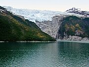
Romanche Glacier at Beagle Channel
-
Puerto Edén - Messier-Canal
-
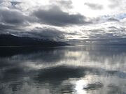
Beagle Channel, January 2006
-
Messier-Canal
-
Puerto Edén - Messier-Canal
-
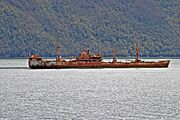
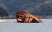
Shipwreck Logos in the Beagle Channel
-
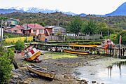
Villa Puerto Edén in Paso del Indio
-
Caleta Tortel in Baker Channel
-
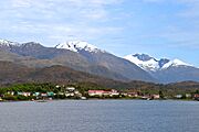
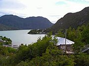
Reloncaví Estuary, Chilé's northernmost fjord
-
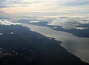
Aerial view of Beagle Channel
-
USS Riverside (APA-102) shipwreck in the Smyth Channel
-
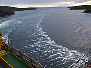
MV Evangelistas passes English Narrows early in the morning, in journey from Puerto Natales to its destination, Puerto Montt.
-
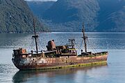
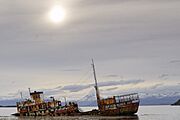
Wreck of the Capitan Leonidas serves as a warning for the submerged Bajo Cotopaxi (Cotopaxi Bank) in the Messier Channel.
-
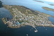
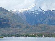
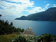
Aerial view of the Ascención Island, known as Melinka
_-_Chilenische_Fjorde.jpg)


_-_Chilenische_Fjorde.jpg)

.jpg)


See also
- Archipelagoes of Patagonia
- Borde costero
- Geography of Chile
- Islands of Chile
- List of Antarctic and subantarctic islands
- List of fjords, channels, sounds and straits of Chile
- List of islands of Chile
- List of lighthouses and lightvessels in Chile
