
Ancud facts for kids
Quick facts for kids
Ancud
|
||||||
|---|---|---|---|---|---|---|

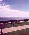
Partial view of Ancud
|
||||||
|
||||||
| Country | Chile | |||||
| Region | Los Lagos | |||||
| Province | Chiloé | |||||
| Founded as | San Carlos de Chiloé | |||||
| Founded | 20 August 1768 | |||||
| Government | ||||||
| • Type | Municipality | |||||
| Area | ||||||
| • Total | 1,252.4 km2 (483.6 sq mi) | |||||
| Elevation | 0 m (0 ft) | |||||
| Population
(2012 Census)
|
||||||
| • Total | 40,819 | |||||
| • Density | 32.5926/km2 (84.415/sq mi) | |||||
| • Urban | 27,292 | |||||
| • Rural | 12,654 | |||||
| Demonym(s) | Ancuditano | |||||
| Sex | ||||||
| • Men | 19,793 | |||||
| • Women | 20,153 | |||||
| Time zone | UTC−4 (CLT) | |||||
| • Summer (DST) | UTC−3 (CLST) | |||||
| Area code(s) | 56 + 65 | |||||


Ancud is a city in southern Chile. It is found on the northern part of Chiloé Island. This island is part of the Chiloé Province in the Los Lagos Region. Ancud is the second largest city in the Chiloé Archipelago. Only Castro is bigger.
The city was started in 1768. It was the capital of the archipelago until 1982. Ancud was built as a strong point against other countries during colonial times. It also helped Chile explore and settle Patagonia in the 1800s.
Contents
Exploring Ancud's Geography
Ancud is located in a special place. To the north, the Chacao Channel separates Chiloé Island from mainland Chile. This channel was carved out by many glaciations (ice ages). It marks the border between two natural areas of Chile. The Zona Sur is to the north, and the Zona Austral is to the south.
The Pacific Ocean is to the west. The Chilean Coastal Range continues here as a chain of islands. To the southeast of Ancud is Quemchi. To the south is Dalcahue. The area of Ancud is about 1,752.4 square kilometers. West of Ancud are small coastal towns like Pumillahue and Quetalmahue. About 25 kilometers west of Ancud, you can find the Islotes de Puñihuil Natural Monument. This is a group of protected islands. Many types of penguins live there.
A Look at Ancud's History
Before the Spanish built a settlement, the area of Ancud was called Puerto Inglés. This means "English Port." It was here that Hendrik Brouwer died on August 7, 1643. He was the leader of a Dutch trip to Valdivia.
After the Seven Years' War, Spain decided to improve its coastal forts in Chile. So, in 1767–1768, the Spanish founded the "city-fort" of Ancud. They also made Chiloé a direct part of the Viceroyalty of Peru. This meant it was no longer part of the Captaincy General of Chile. Building Ancud helped local trade and farming grow. This was also true for other forts built in Chile during the 1700s. A new road, the Ancud-Castro road, also helped with this growth.
From 1839 to 1864, the Chilean Navy had a special school in Ancud. It was called the Ancud Nautic School. Francisco Hudson was one famous student from this school.
Ancud's Climate and Weather
Ancud has an oceanic climate. This means it gets a lot of rain every month. Winters are cool and wet. In July, the average temperature is about 7.5°C (45.5°F). It rains a lot during winter, about 350 mm (13.8 inches) per month. The air is also very humid, around 87-88%.
Summers are mild. In January, the average temperature is about 15.0°C (59.0°F). It rains less in summer, about 125 mm (4.9 inches) in January. Temperatures rarely go above 30°C (86°F). On average, Ancud gets about 2,540 mm (100 inches) of rain each year. There are about 200 days with rain.
However, the amount of rain can change a lot each year. For example, 1993 was the driest year, with only 759 mm (29.9 inches) of rain. But 1977 was the wettest, with 3,712 mm (146.1 inches) of rain. The hottest day ever recorded was 32.7°C (90.9°F) on January 27, 1975. The coldest day was -3.0°C (26.6°F) on June 30, 1970.
| Climate data for Ancud | |||||||||||||
|---|---|---|---|---|---|---|---|---|---|---|---|---|---|
| Month | Jan | Feb | Mar | Apr | May | Jun | Jul | Aug | Sep | Oct | Nov | Dec | Year |
| Record high °C (°F) | 32.7 (90.9) |
28.2 (82.8) |
31.0 (87.8) |
24.7 (76.5) |
17.8 (64.0) |
19.2 (66.6) |
20.0 (68.0) |
17.2 (63.0) |
22.1 (71.8) |
23.6 (74.5) |
25.2 (77.4) |
30.0 (86.0) |
32.7 (90.9) |
| Mean daily maximum °C (°F) | 17.8 (64.0) |
17.8 (64.0) |
16.5 (61.7) |
13.8 (56.8) |
11.6 (52.9) |
9.8 (49.6) |
9.4 (48.9) |
10.0 (50.0) |
11.3 (52.3) |
13.0 (55.4) |
14.8 (58.6) |
16.5 (61.7) |
13.5 (56.3) |
| Daily mean °C (°F) | 15.0 (59.0) |
14.8 (58.6) |
13.6 (56.5) |
11.4 (52.5) |
9.7 (49.5) |
7.9 (46.2) |
7.5 (45.5) |
8.0 (46.4) |
9.1 (48.4) |
10.6 (51.1) |
12.3 (54.1) |
13.9 (57.0) |
11.1 (52.0) |
| Mean daily minimum °C (°F) | 10.9 (51.6) |
10.3 (50.5) |
9.6 (49.3) |
8.2 (46.8) |
7.2 (45.0) |
5.6 (42.1) |
5.2 (41.4) |
5.4 (41.7) |
6.1 (43.0) |
7.0 (44.6) |
8.6 (47.5) |
10.0 (50.0) |
7.8 (46.0) |
| Record low °C (°F) | 1.6 (34.9) |
0.9 (33.6) |
0.9 (33.6) |
0.0 (32.0) |
0.0 (32.0) |
−3.0 (26.6) |
−2.8 (27.0) |
−2.2 (28.0) |
−2.0 (28.4) |
0.2 (32.4) |
1.8 (35.2) |
0.0 (32.0) |
−3.0 (26.6) |
| Average precipitation mm (inches) | 124.6 (4.91) |
107.4 (4.23) |
129.6 (5.10) |
195.4 (7.69) |
354.2 (13.94) |
361.4 (14.23) |
326.6 (12.86) |
271.4 (10.69) |
221.3 (8.71) |
172.3 (6.78) |
146.9 (5.78) |
128.5 (5.06) |
2,539.6 (99.98) |
| Average precipitation days | 14 | 11 | 13 | 16 | 20 | 21 | 20 | 20 | 19 | 16 | 16 | 14 | 200 |
| Average relative humidity (%) | 74 | 76 | 79 | 84 | 88 | 88 | 87 | 85 | 82 | 78 | 76 | 75 | 81 |
| Source: Dirección Meteorológica de Chile | |||||||||||||
| Climate data for Punta Corona | |||||||||||||
|---|---|---|---|---|---|---|---|---|---|---|---|---|---|
| Month | Jan | Feb | Mar | Apr | May | Jun | Jul | Aug | Sep | Oct | Nov | Dec | Year |
| Mean daily maximum °C (°F) | 16.7 (62.1) |
16.7 (62.1) |
15.1 (59.2) |
13.7 (56.7) |
11.9 (53.4) |
10.7 (51.3) |
10.2 (50.4) |
10.3 (50.5) |
11.0 (51.8) |
12.5 (54.5) |
13.5 (56.3) |
15.1 (59.2) |
13.1 (55.6) |
| Daily mean °C (°F) | 13.7 (56.7) |
13.5 (56.3) |
12.7 (54.9) |
11.2 (52.2) |
9.6 (49.3) |
8.7 (47.7) |
8.3 (46.9) |
8.2 (46.8) |
8.7 (47.7) |
9.9 (49.8) |
10.9 (51.6) |
12.4 (54.3) |
10.7 (51.2) |
| Mean daily minimum °C (°F) | 10.5 (50.9) |
10.3 (50.5) |
9.6 (49.3) |
8.2 (46.8) |
7.0 (44.6) |
6.1 (43.0) |
5.7 (42.3) |
5.5 (41.9) |
5.9 (42.6) |
7.1 (44.8) |
8.1 (46.6) |
9.5 (49.1) |
7.8 (46.0) |
| Average precipitation mm (inches) | 83.5 (3.29) |
109.8 (4.32) |
153.9 (6.06) |
213.3 (8.40) |
328.0 (12.91) |
332.8 (13.10) |
315.0 (12.40) |
273.7 (10.78) |
205.2 (8.08) |
124.5 (4.90) |
141.1 (5.56) |
119.7 (4.71) |
2,400.5 (94.51) |
| Average relative humidity (%) | 85 | 86 | 88 | 89 | 89 | 89 | 89 | 88 | 86 | 86 | 85 | 86 | 87 |
| Source: Bioclimatografia de Chile | |||||||||||||
Who Lives in Ancud? (Demographics)
In 2002, a census (a count of people) was done by the National Statistics Institute. It showed that Ancud has an area of 1,252.4 square kilometers. There were 39,946 people living there. This included 19,793 men and 20,153 women.
Most people, about 27,292 (68.3%), lived in urban areas (cities and towns). The rest, 12,654 (31.7%), lived in rural areas (the countryside). The population grew by 6.5% between 1992 and 2002. This was an increase of 2,430 people. If you are from Ancud, you are called an Ancuditano (for a boy or man) or an Ancuditana (for a girl or woman).
How Ancud is Governed
Ancud is a commune. This means it is a local government area in Chile. It is managed by a municipal council. The head of the council is an alcalde (mayor). The mayor is chosen directly by the people every four years. From 2008 to 2012, the mayor was Federico Krüger Finterbüch.
Ancud is part of the 58th electoral district in Chile. This district elects members to the Chamber of Deputies. The current representatives are Mr. Gabriel Ascencio and Mr. Alejandro Santana. Ancud is also part of the 17th senatorial constituency. This constituency elects members to the Senate. The current senators are Camilo Escalona Medina and Carlos Kuschel Silva.
Important Places in Ancud
Ancud Cathedral
The Cathedral of Ancud is the main church in the city. The current building was built after a big earthquake in 1960. It stands in the same spot where the old church was destroyed by that earthquake.
Old Forts of Ancud

Ancud has a system of old forts. These forts, along with those at Agüi, were important for protecting colonial Chiloé. The fort system of Ancud includes two forts and four batteries (places where cannons were set up).
- Fuerte Real de San Carlos: This fort was built in 1824. It was ordered by Antonio de Quintanilla. He was the last Spanish governor of Chiloé. You can still see the old arsenal (polvorín), which was a place to store weapons and gunpowder. It is now in the middle of a small plaza.
- Battery of San Antonio: This is the best-preserved part of the fort system. It gives you a good idea of what the old defenses looked like.
Gallery
-
Fuerte San Antonio
-
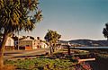
Avenida Salvador Allende
-
Avenida Salvador Allende
-
Cathedral
-
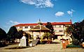
Plaza de Armas and Town Hall
-
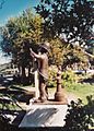
Firebrigade Monument


See also
 In Spanish: Ancud para niños
