Captaincy General of Chile facts for kids
Quick facts for kids
General Captaincy of Chile
Kingdom of Chile Capitanía General de Chile
Reino de Chile |
|||||||||
|---|---|---|---|---|---|---|---|---|---|
| 1541-1810 1814-1817 |
|||||||||
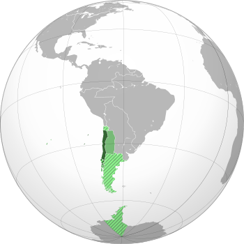
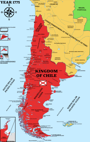
Map of the Captaincy General of Chile in 1796 and claimed territories
|
|||||||||
| Status | Kingdoms of Indies of the Hispanic Monarchy | ||||||||
| Capital | Santiago | ||||||||
| Common languages | Castilian Spanish (official) Indigenous languages (Quechuan languages, Aymara, Mapudungun, Kawésqar, Yaghan) |
||||||||
| Religion | Roman Catholicism | ||||||||
| Government | Monarchy | ||||||||
| King | |||||||||
|
• 1541–1556
|
Charles I | ||||||||
|
• 1808–1813
|
Joseph I | ||||||||
|
• 1813–1818
|
Ferdinand VII | ||||||||
| Royal Governor | |||||||||
|
• 1541–1553
|
Pedro de Valdivia | ||||||||
|
• 1808-1810
|
Francisco García Carrasco | ||||||||
|
• 1815–1817
|
Casimiro Marcó del Pont | ||||||||
| Historical era | Spanish Empire | ||||||||
|
• Established
|
1541 | ||||||||
| September 18, 1810 | |||||||||
| October 2, 1814 | |||||||||
| February 12 1817 | |||||||||
| Currency | Spanish Real | ||||||||
| ISO 3166 code | CL | ||||||||
|
|||||||||
The General Captaincy of Chile (Capitanía General de Chile) was a part of the Spanish Empire. It existed from 1541 to 1817. At first, it was part of the Viceroyalty of Peru. This territory included most of what is now Chile. It also covered southern parts of Argentina in the Patagonia region. Its main city was Santiago.
In 1810, the people of Chile declared themselves independent. However, Spain took back control in 1814. But by 1817, Chile finally became independent. It was then known as the Republic of Chile. Many Spanish governors and several kings ruled over Chile during this long period.
Contents
What Was the Captaincy General of Chile?
The Captaincy General of Chile was added to the Crown of Castile. This was like all other Spanish lands in the New World. At first, it was called New Extremadura. Later, it was also known as Indian Flanders.
Many people, including Benjamin Vicuna Mackena, said Chile was always officially called the "Kingdom of Chile." Old books from the 16th, 17th, and 18th centuries confirm this name. Even though it was called a kingdom, it was mostly controlled by Spain. Later, it became a republic.
The Captaincy General of Chile was managed by the Council of the Indies. It followed the Laws of the Indies. This was similar to other Spanish colonies. Viceroys and governors handled daily tasks. They represented the king in these faraway lands. Areas with advanced civilizations or rich societies were often called "kingdoms" by the Spanish.
Chile's Early History
Exploring and Conquering Chile
In 1536, Diego de Almagro led the first trip to explore lands south of the Inca Empire. After Almagro died, Pedro de Valdivia got permission in 1539. He was allowed to explore and conquer the area. Francisco Pizarro approved his plan.
Valdivia founded the city of Santiago del Nuevo Extremo. A few months later, its cabildo (city council) named him governor. This happened on June 11, 1541. Valdivia founded other cities too:
- Concepción (1550)
- La Imperial (1551)
- Santa María Magdalena de Villa Rica (1552)
- Santa María la Blanca de Valdivia (1552)
- Los Confines (1553)
- Santiago del Estero (1553)
In 1553, Valdivia also built forts to protect the settled areas. These included San Felipe de Araucan and San Diego de Tucapel. After Valdivia died that same year, some forts and cities were lost. They were later won back after wars with Lautaro and Caupolicán.
More cities were founded after the Mapuche people were defeated. These included:
- Cañete de la Frontera (1558)
- Villa de San Mateo de Osorno (1558)
- Ciudad de Mendoza (1561)
- San Luis de Loyola (1562)
- San Juan de la Frontera (1562)
- Santiago de Castro (1567)
Martín García Óñez de Loyola founded the last city south of the Bio Bio River, Santa Cruz de Coya, in 1595.
The Mapuche Uprising in Southern Chile
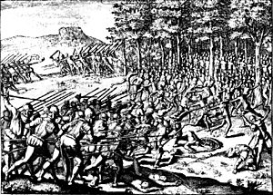
A major Mapuche uprising began on December 23, 1598. This happened after the battle of Curalaba. In that battle, the Mapuche leader Pelantaru and his men attacked and killed the Spanish governor Martín García Óñez de Loyola. Almost all his companions died too.
Over the next few years, the Mapuche destroyed or forced the Spanish to leave seven cities in their territory:
- Santa Cruz de Coya (1599)
- Santa María la Blanca de Valdivia (1599)
- San Andrés de Los Infantes (1599)
- La Imperial (1600)
- Santa María Magdalena de Villa Rica (1602)
- San Mateo de Osorno (1602)
- San Felipe de Araucan (1604)
17th Century: Building the Colony
In the 1600s, the Spanish colony in Chile changed. In the 1500s, most Spanish cities were south of the Biobío River. But in the 1600s, Spanish control moved north of the Bio-Bio. Chile went from exporting gold to being a poorer colony. It had fewer natural resources.
Spain had to send silver from Potosí to pay for an army in Chile. This army fought in the Arauco War. Also, Francis Drake and later Dutch pirates attacked Chilean waters. Spain tried to block the entrance to the Pacific Ocean at the Strait of Magellan. But they stopped after finding Hoces Sea. They then focused on protecting coastal cities. This was cheaper and better for fighting pirates. It also helped keep the area under Spanish rule.
18th Century: Changes and Growth
Chile lost some land because of the Bourbon Reforms by Charles III of Spain. The cities of Mendoza and San Juan were moved. They became part of the new Viceroyalty of the Río de la Plata in 1776.
However, Chile gained two new administrative areas called intendancies. These were Santiago and Concepción in 1786. In 1789, Chile officially became a Bourbon-style Captaincy General.
How Chile Was Governed
At first, the area was called a gobernación (governorship). But the local Native American people fought back strongly. So, a more independent, military-based government was needed. The governor was given control of the local army. He was also given the title of captain general. This system was used in many parts of the Spanish Empire.
A huge defeat for the Spanish was the Disaster of Curalaba in 1598. Almost all Spanish cities south of the Biobío River were destroyed. Only Castro remained. The Biobío River then became La Frontera. This was the unofficial border between Spanish and Native lands for the next 100 years. (See Arauco War.)
Life in Colonial Chile
Different Groups of People
Colonial society in Chile had a caste system. This meant people were grouped by their background.
- Criollos were Spaniards born in America. They had special rights. They owned encomiendas (areas where they could use Native American labor). They could also hold some government jobs.
- Mestizos were people of mixed Spanish and Native American heritage. At first, they were a small group. But over time, they became the largest group in Chile. They were judged more by how they looked and their education.
- Native peoples faced the most unfair treatment. Many were forced to work in encomiendas. Their numbers went down because of disease and hard labor. Groups like the Pehuenches and Mapuches living south of La Frontera were not part of this colonial society. They lived outside the Spanish-controlled areas.
- Black slaves were a small group. They were expensive to bring in and keep. They often worked as housekeepers or in other trusted roles.
- Peninsulares were Spaniards born in Spain. They were a small group later in colonial times. Some came as government officials, others as merchants. Their high positions caused some anger among the local Criollos.
People from different groups sometimes had children together. However, marriage between different groups was rare.
Later, many Basque people from Spain moved to Chile. They mixed with the Criollo landowners. This created a new upper class. Some historians believe that 45% of all immigrants to Chile in the 17th and 18th centuries were Basques.
Marriage in Colonial Times
Many Spanish conquerors in the 16th century left their families in Spain. They started new relationships in Chile. For example, Pedro de Valdivia had Inés de Suárez as his partner while in Chile.
Chile's Claim to Antarctica in Colonial Times
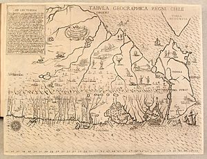
For many years, mapmakers and explorers wondered about Terra Australis Incognita. This was believed to be a huge land south of the Strait of Magellan and Tierra del Fuego. It was thought to reach the South Pole.
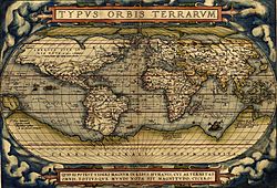
The Treaty of Tordesillas (1494) divided the world between Spain and Portugal. This treaty meant that the Antarctic areas, even though unknown then, would belong to Spain. This treaty was supported by the Pope. But not all European countries agreed with it.
In 1534, Emperor Charles V divided South America into three areas:
- New Castile (Peru) for Francisco Pizarro
- New Toledo (Chile) for Diego de Almagro
- New León (Magellanic Lands) for Simón de Alcazaba y Sotomayor
In 1539, a new area called Terra Australis was created south of New León. It was given to Pedro Sanchez de la Hoz. In 1554, Pedro de Valdivia, the governor of Chile, asked for the rights to New León and Terra Australis. After Valdivia died, these lands were added to Chile.
Many old documents show this. A Royal Decree from 1554 says:
Because it was personally consulted, we will grant, to the Captain Jeronimo de Alderete the land across the Magellan Strait
Later, in 1558, a Royal Decree from Brussels told the Chilean government to "take ownership in our name from the lands and provinces that fall in the demarcation of the Spanish crown." This referred to the land "across the Strait." At that time, people thought Tierra del Fuego was part of Terra Australis.
The famous Spanish poem La Araucana by Alonso de Ercilla (1569) also supports Chile's claim. It describes Chile as extending far south, under the Antarctic Pole.
There are also stories and maps that show Antarctica as part of the Captaincy General of Chile. The Spanish sailor Gabriel de Castilla sailed from Valparaiso in 1603. He reached 64 degrees south latitude. This was very far south. A Dutch sailor, Laurenz Claesz, wrote about this trip. He said they reached 64 degrees south and saw a lot of snow.
Another Dutch document from 1622 said that at 64°S, there were "very high and mountainous, snow cover, like the country of Norway, all white, land It seemed to extend to the Solomon Islands." This might mean they saw the South Shetland Islands.
Some historians think the Dutch sailor Dirk Gerritsz was the first to see Antarctic land. His ship was blown off course in 1599 after passing the Strait of Magellan. He might have found the islands now called South Shetland.
By this time, people knew there was a white continent south of the Drake Passage. It was separate from Tierra del Fuego. In 1772, the British explorer James Cook sailed around the Southern Ocean.
See also
 In Spanish: Capitanía general de Chile para niños
- Real Audiencia of Concepción
- Royal Governor of Chile
- Spanish immigration to Chile
- Chilean Antarctica in colonial times
 | Aurelia Browder |
 | Nannie Helen Burroughs |
 | Michelle Alexander |


