Governorate of New León facts for kids
Quick facts for kids
Governorate of New León
Gobernación de Nueva León
|
|||||||||||||||||||
|---|---|---|---|---|---|---|---|---|---|---|---|---|---|---|---|---|---|---|---|
| 1529–?? | |||||||||||||||||||
|
Flag
|
|||||||||||||||||||

|
|||||||||||||||||||
| Status | Governorate of the Crown of Castile | ||||||||||||||||||
| Capital | Puerto de los Leones | ||||||||||||||||||
| Official languages | Spanish | ||||||||||||||||||
| Religion | Catholicism | ||||||||||||||||||
| Government | Monarchy | ||||||||||||||||||
| King | |||||||||||||||||||
|
• 1529-1542
|
Simón de Alcazaba y Sotomayor | ||||||||||||||||||
| Historical era | Spanish Empire | ||||||||||||||||||
|
• Created by Capitulación de Toledo
|
1529 | ||||||||||||||||||
|
• Dissolved by Real Cédula
|
?? | ||||||||||||||||||
| Currency | Escudo | ||||||||||||||||||
|
|||||||||||||||||||
The Governorate of New León was a large area of land in South America. It was controlled by the Crown of Castile (which was part of Spain). This area was created in 1534.
It was first given to a Spanish explorer named Simón de Alcazaba y Sotomayor. Later, another person named Francisco de Camargo took charge. The territory grew to include the Strait of Magellan. This strait is a famous waterway at the southern tip of South America.
History of New León
The Governorate of New León was set up by King Charles V of Spain. This happened in 1529. The king gave special permission to Simón de Alcazaba y Sotomayor. He became the first governor and main leader of this new territory.
The land was described as stretching along the Pacific coast. It was about 200 leagues (a very long distance) south from another Spanish territory. That territory was called Governorate of New Andalusia.
On May 21, 1534, the king signed more agreements. These agreements were to explore and take over more lands in America. They created new provinces or governorates. Each was about 200 leagues long from north to south. The Governorate of New León was one of these. It stretched from the Atlantic Ocean to the Pacific Ocean. Its northern border was around Coronel and Pinamar. Its southern border was near Campana Island and Laura Bay.
Later, the Governorate was made even bigger. It was extended all the way to the Strait of Magellan. This included the lands south of the strait as well.
Spanish Divisions in South America
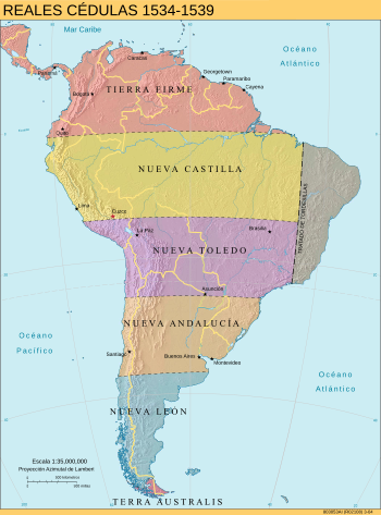
After Spain and Portugal divided South America, Spain organized its lands. The Spanish administration in Peru was split into six main parts. These were:
- Province of Tierra Firme: This included the Caribbean Coast, Central America, and parts of Colombia and Mexico.
- Governorate of New Castile: This area stretched from the border of Ecuador and Colombia in the north to Cuzco in the south.
- Governorate of New Toledo: This formed the southern part of the old Inca empire. It reached towards central Chile.
- Governorate of New Andalusia: Spain did not fully conquer this area until many years later.
- Governorate of New León: This was the southernmost part of the continent. It went all the way to the Strait of Magellan.
- Governorate of Terra Australis: This included lands south of the Strait of Magellan, reaching towards the South Pole.
These divisions helped Spain manage its new lands for several decades. However, they were officially ended in 1544. King Charles I (who was also Charles V) sent his special representative, Blasco Núñez Vela. He came to govern the new Viceroyalty of Peru. This new viceroyalty replaced all the old governorates.
See also
 In Spanish: Gobernación de Nueva León para niños
 | May Edward Chinn |
 | Rebecca Cole |
 | Alexa Canady |
 | Dorothy Lavinia Brown |


