Province of Tierra Firme facts for kids
Quick facts for kids
Province of Tierra Firme
Provincia de Tierra Firme
|
|||||||||||
|---|---|---|---|---|---|---|---|---|---|---|---|
| 1498–1537 | |||||||||||

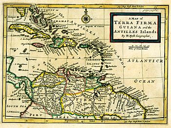
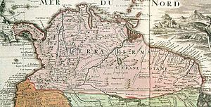
Spanish map of the Tierra Firme
|
|||||||||||
| Status | Province of the Crown of Castile | ||||||||||
| Capital | Santa María la Antigua del Darién Panama City |
||||||||||
| Common languages | Spanish | ||||||||||
| Religion | Catholicism | ||||||||||
| Government | Monarchy | ||||||||||
| King | |||||||||||
|
• 1492-1516
|
Ferdinand II and Isabella I | ||||||||||
|
• 1516–1556
|
Charles I | ||||||||||
| Historical era | Spanish Empire | ||||||||||
|
• Established
|
1498 | ||||||||||
|
• Creation of the Viceroyalty of Peru
|
1537 | ||||||||||
| Currency | Peso | ||||||||||
|
|||||||||||
When Spain started to explore and settle new lands in the Americas, they called the coastal areas around the Caribbean Sea and the Gulf of Mexico the Spanish Main. The southern part of these coastal lands was known as the Province of Tierra Firme. This name means "Mainland Province" in Spanish. It helped people tell it apart from Spain's nearby islands. Tierra Firme was also sometimes called Costa Firme.
Contents
History of Tierra Firme
Early Explorations and Settlements
In 1498, Christopher Columbus sailed into the Gulf of Paria in Venezuela. He also explored the Orinoco River. On his last trip, he explored Honduras.
In 1509, two Spanish explorers, Alonso de Ojeda and Diego de Nicuesa, were given permission to settle these new lands. Their territories stretched from the west side of the Gulf of Urabá to Cabo de la Vela. They also went from Urabá westward to Cabo Gracias a Dios in today's Honduras. The westernmost part of these lands was named Tierra Firme.
Neighboring Provinces and Main Cities
During this time, other areas nearby included Nueva Andalucia and Veragua (also called Castilla del Oro). The most important city in Tierra Firme was Santa María la Antigua del Darién. This city is now in Darién, Panama, close to the Tarena river. The Spanish wanted to create a single government for these areas, similar to how they ruled Nueva España (which is now Mexico).
Expanding the Borders
Over time, Tierra Firme grew to include more territories. It took control of Isla de Santiago (now Jamaica) and the Cayman Islands. It also included Roncador, Quitasueño, and Providencia. These islands are now part of Colombia. The lands of modern-day Costa Rica and Nicaragua up to Cabo Gracias a Dios were also added.
The eastern border of Tierra Firme included the east side of the Gulf of Darién (or Urabá). It also covered the east side of the Atrato and Truando rivers. This border ended at Cabo Marzo on the Pacific Ocean side. Within these borders were Santa Maria La Antigua Del Darien on the Gulf of Urabá and Jurado on the Pacific side.
Border Challenges
When countries in Central America became independent, the exact borders of Tierra Firme were not always clear. Some old maps and historical records suggested that the entire Caribbean coast, all the way to Cabo Gracias a Dios, was part of Tierra Firme. However, this would have included areas like the Mosquito Coast, which Tierra Firme never truly controlled. Disagreements about Panama's borders were eventually settled through agreements with Costa Rica and Colombia.
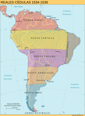
Spanish Governorates in South America

After Spain and Portugal divided South America, the Spanish lands in Peru were split into six main areas. These were called governorates:
- Province of Tierra Firme: This included the Caribbean Coast, Central America, and the Pacific Coast of Colombia and Mexico.
- Governorate of New Castile: This area stretched from the border of Ecuador and Colombia in the north down to Cuzco in the south.
- Governorate of New Toledo: This was the southern half of the old Inca Empire. It reached towards central Chile.
- Governorate of New Andalusia: Spain did not fully conquer this area until many years later.
- Governorate of New León: This was the southernmost part of the continent, reaching down to the Strait of Magellan.
- Governorate of Terra Australis: This included lands south of the Strait of Magellan, all the way to the South Pole.
These divisions helped Spain manage its new lands in South America for several decades. In 1544, King Charles I changed this system. He sent Blasco Núñez Vela to govern the new Viceroyalty of Peru. This new viceroyalty replaced the old governorates.
See also
 In Spanish: Reino de Tierra Firme para niños
 | Percy Lavon Julian |
 | Katherine Johnson |
 | George Washington Carver |
 | Annie Easley |


