
Puerto Natales facts for kids
Quick facts for kids
Puerto Natales
Natales
|
|||||
|---|---|---|---|---|---|
 |
|||||
|
|||||
| Nickname(s):
Natales
|
|||||
| Country | |||||
| Region | |||||
| Province | Última Esperanza | ||||
| Commune | Natales | ||||
| Founded | 1911 | ||||
| Government | |||||
| • Type | Municipality | ||||
| Area | |||||
| • Total | 48,974.2 km2 (18,909.0 sq mi) | ||||
| Elevation | 3 m (10 ft) | ||||
| Population
(2012 Census)
|
|||||
| • Total | 18,505 | ||||
| • Density | 0.377852/km2 (0.978632/sq mi) | ||||
| • Rural | 2,138 | ||||
| Sex | |||||
| • Men | 10,068 | ||||
| • Women | 9,048 | ||||
| Time zone | UTC−3 (CLST) | ||||
| Area code(s) | 56 + 61 | ||||
| Website | www.muninatales.cl | ||||


Puerto Natales is a city in Chilean Patagonia. It is the main city of the Natales commune and the Última Esperanza Province. This province is one of four that make up the Magallanes and Antartica Chilena Region. This region is located in the southernmost part of Chile.
Puerto Natales is the only city in its province. It is about 247 kilometers (153 miles) northwest of Punta Arenas. The city is the last stop for the Navimag ferry coming from Puerto Montt. It is also the main starting point for travelers visiting Torres del Paine National Park.
The city is located at the entrance of Última Esperanza Sound. The area was first home to the Kawésqar (also called Alacaluf) and the Aoniken (also called Tehuelche) people. The first Europeans to arrive were led by Juan Ladrillero in 1557. He was a Spanish explorer looking for the western passage to the Strait of Magellan.
Puerto Natales was settled in the late 1800s. Immigrants came from Germany, Britain, Croatia, Greece, Italy, and Spain. Many Chileans also moved there, especially from Chiloé Archipelago. They were all drawn by the sheep farming industry. The city was officially founded on May 31, 1911. Today, tourism is a very important industry. Cattle farming and fish farming are also significant. While it's windy and cold, some local produce like zucchini, cherry tomatoes, strawberries, cucumbers, and carrots are grown.
Contents
History of Puerto Natales
The province where Puerto Natales is located was named Última Esperanza, meaning "Last Hope." This name was given by the sailor Juan Ladrillero in 1557. He was searching for the Strait of Magellan. It was his "last hope" to find the strait after exploring many channels.
About 300 years later, in 1830, another big expedition sailed through the fjords of Última Esperanza. This was the British expedition of the ship HMS Beagle. Some members, like Robert FitzRoy, are remembered in local place names. Fitzroy was the captain during the second voyage of the HMS Beagle (1831–1836).
In 1870, people became interested in the Última Esperanza region again. Santiago Zamora, known as 'Baqueano' Zamora, was one of the brave travelers. He found the lakes in the Torres del Paine area. He also found many wild horses, called baguales. Another famous traveler was the English writer Lady Florence Dixie. The city's Hotel Lady Florence Dixie is named after her. Dixie wrote a book called Across Patagonia. In it, she described the first tourist trip to Torres del Paine. She called the three granite spires "Cleopatra's needles."

Puerto Natales was founded in May 1911. It served as a port for the sheep farming industry. In the second half of the 1900s, sheep farming became less important. Many people from Puerto Natales then started working in the coal mines of Río Turbio in Argentina.
When sheep farming was at its peak in Patagonia, two large "frigorificos" (cold-storage plants) were built. One of them still exists. The plant at Puerto Bories, about 4 km (2.5 miles) northwest of Puerto Natales, opened in 1913. It was part of a project by the Sociedad Explotadora de Tierra del Fuego. This plant operated until 1993. The cold-storage plant was built in a "Post Victorian Industrial" style. It shows many examples of British machinery from the early 1900s. This complex is an important part of the area's industrial history. In 2010, a project began to turn the old plant into a luxury hotel called The Singular Patagonia.
In 1919, workers from the Federación Obrera de Magallanes went on strike. They took control of the town. Later, the government stopped the strike.
Things to Do in Puerto Natales
Puerto Natales has many places for tourists. It is a popular starting point for trips to Torres del Paine National Park. This park is one of the most famous national parks in Chile.
Torres del Paine National Park
The main feature of the park is its mountainous "towers" (torres). These are impressive and unique rock formations. They include the Torre Central (Central Tower), which is 2,800 meters (9,186 feet) high. The Torre Sur (South Tower) is 2,850 meters (9,350 feet) high. The Torre Norte (North Tower) is 2,248 meters (7,375 feet) high.
Unesco has named the park a World Biosphere Reserve. It is home to hundreds of different birds and many types of mammals. It also has the third-largest ice field on Earth. The national park is open all year. However, the best time to visit is from October to April. This is spring and summer in the southern hemisphere. During this time, there are more sunny days, less rain, and over 16 hours of daylight.
Cueva del Milodón Natural Monument
About 24 kilometers (15 miles) northwest of Puerto Natales, you can find the Cueva del Milodón Natural Monument. It is located along the Cerro Benitez Mountains. This monument includes several caves and a rock formation called the Silla del Diablo (Devil's Chair).
The main cave was used by prehistoric tribes. In 1895, explorers found skin, bones, and other parts of a giant ground sloth there. This animal was called the Mylodon (Mylodon darwini), and it is now extinct. The area also includes the Bernardo O'Higgins National Park and the Alacalufes National Reserve. The reserve is home to the Fjord of the Mountains, Cordillera Riesco, and Cordillera Sarmiento.
Nao Victoria Museum
This museum is in nearby Punta Arenas. The Nao Victoria was one of five ships in the Spanish Armada de Molucca expedition. It was the only ship that survived the journey. This expedition discovered where the Atlantic and Pacific oceans meet. A realistic and accurate replica of the ship is at the museum. It helps visitors imagine the historic voyage.
Explore the Fjords
Companies offer boat trips through the Patagonian fjords. These trips start from Puerto Natales Pier. Tourists can see many icebergs in the region.
Outdoor Adventures
- Bike trips around Torres del Paine National Park are a peaceful way to see nature. You can admire the majestic sights.
- Horseback riding lets you visit the unique farms around Puerto Natales.
- Kayaks offer a quieter way to explore than boat trips. They are perfect for seeing the fjord landscapes from a different angle.
Travel and Stay
Today, Puerto Natales has many places to stay. There are camping sites, hostels, hotels, and bed & breakfasts. You can also find many restaurants and transportation services. These options fit different budgets.
How to Get to Puerto Natales
There are daily LATAM flights from Santiago, Chile’s capital city. These flights go to the Presidente Carlos Ibáñez del Campo International Airport in Punta Arenas. The smaller Sky Airline offers direct flights to the Teniente Julio Gallardo Airport near Puerto Natales. These flights run three times a week.
By land, Puerto Natales is about 3,100 km (1,926 miles) from Santiago. It is about 2,300 km (1,429 miles) from Puerto Montt. It is also about 1,600 km (994 miles) from Coyhaique.
Population and Area

According to the 2002 census by the Chilean National Statistics Institute, the Natales commune has 19,116 people. This includes 10,068 men and 9,048 women. Most people, 16,978 (88.8%), live in the city's urban area. The remaining 2,138 (11.2%) live in rural areas. The population grew by 10.7% between 1992 and 2002. The commune makes up 96.3% of the province’s total population. Its population density is about 0.38 people per square kilometer (0.98 per square mile).
Puerto Natales is located along the shore of Última Esperanza Sound. It offers views north towards the Cerro Benitez peaks. These peaks are part of the Cerro Toro formation within the Cordillera Manuel Señoret.
The city of Puerto Natales is part of the larger Natales commune. This commune is one of eleven in the Magallanes Region. The entire province of Última Esperanza is divided into only two communes. This means the Natales commune is very large but has few people. Its area is 48,974.2 square kilometers (18,909 square miles). This makes it one of the largest communes in Chile. It is even larger than seven of Chile's regions. The city itself is only 3 meters (10 feet) above sea level.
Climate in Puerto Natales
Puerto Natales has an oceanic climate. This means it has cool, short summers and chilly, wet winters. It is the city in Chile with the most rainy days each year, averaging 161 days.
| Climate data for Puerto Natales (1991–2020, extremes 1991–present) | |||||||||||||
|---|---|---|---|---|---|---|---|---|---|---|---|---|---|
| Month | Jan | Feb | Mar | Apr | May | Jun | Jul | Aug | Sep | Oct | Nov | Dec | Year |
| Record high °C (°F) | 27.2 (81.0) |
30.0 (86.0) |
28.6 (83.5) |
24.1 (75.4) |
18.5 (65.3) |
18.4 (65.1) |
16.1 (61.0) |
16.8 (62.2) |
19.8 (67.6) |
20.3 (68.5) |
26.5 (79.7) |
24.8 (76.6) |
30.0 (86.0) |
| Mean daily maximum °C (°F) | 18.8 (65.8) |
18.1 (64.6) |
18.1 (64.6) |
14.3 (57.7) |
10.9 (51.6) |
6.9 (44.4) |
7.7 (45.9) |
8.9 (48.0) |
12.2 (54.0) |
14.0 (57.2) |
15.6 (60.1) |
17.2 (63.0) |
13.6 (56.4) |
| Daily mean °C (°F) | 11.6 (52.9) |
11.5 (52.7) |
10.1 (50.2) |
6.7 (44.1) |
3.7 (38.7) |
1.9 (35.4) |
1.7 (35.1) |
2.9 (37.2) |
5.2 (41.4) |
7.1 (44.8) |
8.9 (48.0) |
10.5 (50.9) |
6.8 (44.3) |
| Mean daily minimum °C (°F) | 4.5 (40.1) |
4.2 (39.6) |
2.6 (36.7) |
−0.3 (31.5) |
−2.9 (26.8) |
−4.0 (24.8) |
−4.0 (24.8) |
−3.3 (26.1) |
−0.5 (31.1) |
−1.6 (29.1) |
2.0 (35.6) |
3.8 (38.8) |
0.0 (32.1) |
| Record low °C (°F) | −2.4 (27.7) |
−7.4 (18.7) |
−6.8 (19.8) |
−8.8 (16.2) |
−10.4 (13.3) |
−13.1 (8.4) |
−18.8 (−1.8) |
−10.8 (12.6) |
−8.2 (17.2) |
−8.0 (17.6) |
−4.1 (24.6) |
−4.1 (24.6) |
−18.8 (−1.8) |
| Average precipitation mm (inches) | 147 (5.8) |
120 (4.7) |
145 (5.7) |
154 (6.1) |
119 (4.7) |
105 (4.1) |
104 (4.1) |
107 (4.2) |
103 (4.1) |
127 (5.0) |
154 (6.1) |
155 (6.1) |
1,540 (60.7) |
| Average precipitation days | 16 | 13 | 15 | 13 | 12 | 12 | 12 | 12 | 12 | 13 | 15 | 16 | 161 |
| Average relative humidity (%) | 73 | 74 | 76 | 81 | 85 | 86 | 85 | 83 | 80 | 74 | 73 | 72 | 79 |
| Mean daily sunshine hours | 7.6 | 7.0 | 6.0 | 4.9 | 4.4 | 3.8 | 3.9 | 5.1 | 5.8 | 6.8 | 7.5 | 7.6 | 5.9 |
| Source 1: Dirección Meteorológica de Chile (normal temperatures and extremes) | |||||||||||||
| Source 2: Climate-Data.org | |||||||||||||
City Government
Puerto Natales is the capital of the Natales commune and the Última Esperanza Province. As a commune, Natales is a local government area in Chile. It is managed by a municipal council. The council is led by an alcalde (mayor), who is chosen directly by voters every four years. The mayor from 2016 to 2020 was Fernando Paredes Mansilla. He belonged to the UDI political party.
Images for kids
-
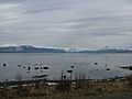
Flamingos in Puerto Natales
-
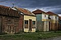
Typical houses in Puerto Natales
-
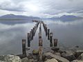
A pier
-
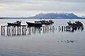
A view of the city
-
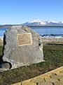
Monument to explorer Juan Ladrillero in Puerto Natales
.jpg)
.jpg)


See also
 In Spanish: Puerto Natales para niños
