Cordillera Sarmiento facts for kids
Quick facts for kids Cordillera Sarmiento |
|
|---|---|
| Highest point | |
| Peak | La Dama Blanca |
| Elevation | 1,941 m (6,368 ft) |
| Dimensions | |
| Length | 65 km (40 mi) North-South |
| Width | 15 km (9.3 mi) West-East |
| Geography | |
| Country | Chile |
| State | Magallanes Region |
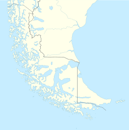
The Cordillera Sarmiento is a mountain range in Chilean Patagonia. It's located west of Puerto Natales. This mountain range is named after Pedro Sarmiento de Gamboa. He was a Spanish explorer who sailed through the region's waterways between 1579 and 1580.
The Cordillera Sarmiento stretches from north to south. It runs along the western shore of the Fjord of the Mountains. It is also parallel to the Cordillera Riesco. The tallest mountain in this range is La Dama Blanca (which means "The White Lady"). It stands at 1,941 m (6,368 ft) high. You can find it at 51°48′S 73°24′W / 51.800°S 73.400°W. This range is part of the larger Andes mountains and has several small glaciers.
Contents
Exploring the Cordillera Sarmiento
The Cordillera Sarmiento is like a long, narrow mountain area. It is about 65 kilometres (40 mi) long and 15 kilometres (9.3 mi) wide. It is a natural part of the Southern Patagonian Ice Field. The center of the range is about 60 kilometres (37 mi) west of Puerto Natales.
Tallest Peaks and Features
The main peaks in this range are La Dama Blanca (1,941 m; 6,368 ft). South of it are Cerro Trono (1,879 m; 6,165 ft) and Alas de Ángel (1,767 m; 5,797 ft). Three other peaks are taller than 1,700 metres (5,600 ft). Many of these mountains are covered in ice or have sharp, rocky points. They often have very steep sides.
It's interesting that many features in the Cordillera Sarmiento don't have official names. This is because very few people live or visit this remote area. However, explorers and climbers have given names to many of the peaks, lakes, glaciers, and rivers over the years.
Ice and Weather
The Cordillera Sarmiento has jagged peaks that rise almost 2,000 metres (6,600 ft). It looks a bit like the French Alps, but it has much more ice. Large glaciers flow down into the ocean. In the past, the ice here was thousands of feet thicker. It carved out the long fjords and shaped the mountains we see today.
Strong winds blow from the nearby sub-Antarctic waters. These "Furious Fifties" winds bring moist, cold air. This air covers the peaks with thick frost. This frost is called "cauliflower ice." It's similar to the ice found on peaks near the Patagonian Ice Cap further north, but it's much denser and lasts longer.
Mountain Rocks
Most climbs in this area are done on snow and ice. The rocks here are part of a special type called the Rocas Verdes formation. These rocks formed when the supercontinent Gondwana began to break apart. This created an ocean basin between a chain of volcanoes and the main continent. The basin filled with basalts, sandstones, shales, and cherts. Over time, these rocks changed deep underground and were later pushed up to form the mountains. The rocks in Sarmiento appear to be very strong.
History of the Cordillera Sarmiento
For thousands of years, the lands around these fjords were home to the Kawésqar (Alacalufe) and Yaghan people. Their stories and names were sadly lost as European settlers arrived in the area.
The first written record of this mountain range was by Juan Ladrillero in 1558. However, his discoveries were soon forgotten. This was because 58 of his 60 men died during his trip, and Ladrillero himself died shortly after. Twenty years later, Pedro Sarmiento de Gamboa followed Ladrillero's path. He then claimed the discovery for himself. Sarmiento first called the mountain range "cordillera nevada," which means "snowy range." This is the range that is now named after him.
Not much more exploration happened in these waters for 250 years. But in the 1830s, Robert Fitz Roy and his crew explored the southern tip of South America. They were on the ship HMS Beagle. They found the fjord that leads to the eastern side of the Cordillera de Sarmiento. They called it the Canal of the Mountains. Today, it's usually known as the Fiordo de las Montañas. They described it as being "bordered on each side by a steep range of mountains." They also noted "deep ravines, which were filled with frozen snow, and surmounted by extensive glaciers, whence huge avalanches were continually falling."
See also
 In Spanish: Cordillera Sarmiento para niños
- Alacalufes National Reserve
- Sarmiento Channel
 | Valerie Thomas |
 | Frederick McKinley Jones |
 | George Edward Alcorn Jr. |
 | Thomas Mensah |


