
Talca facts for kids
Quick facts for kids
Talca
|
|||||
|---|---|---|---|---|---|

1º row: Andes mountains in Talca. 2º row: (left) Town square of Talca, (centre-top) Catholic University of the Maule, (centre-down) Ancient Library of the University of Talca, (right) architectural contrasts. 3º row: Old Intendancy of Maule, statue of Bernardo O'Higgins, BCI Bank. 4º row: 1 Norte street, St. Augustine Cathedral, and 1 Sur street. 5º row: Nocturnal cityscape of Talca.
|
|||||
|
|||||
| Region | Maule Region | ||||
| Province | Talca Province | ||||
| Founded | May 12, 1742 | ||||
| Government | |||||
| • Type | Municipality | ||||
| Area | |||||
| • Total | 231.5 km2 (89.4 sq mi) | ||||
| Elevation | 102 m (335 ft) | ||||
| Population
(2015 Census)
|
|||||
| • Total | 233,339 | ||||
| • Density | 1,007.94/km2 (2,610.6/sq mi) | ||||
| Demonym(s) | Talquino | ||||
| Sex | |||||
| • Men | 111,796 | ||||
| • Women | 121,543 | ||||
| Time zone | UTC−4 (CLT) | ||||
| • Summer (DST) | UTC−3 (CLST) | ||||
| Postal code |
3460000
|
||||
| Area code(s) | 56 (country) + 712 (Talca Province) | ||||
| Climate | Csb | ||||


Talca is a city and commune in Chile. It is located about 255 kilometers (158 miles) south of Santiago. Talca is the capital of both Talca Province and the Maule Region. In 2012, the city had a population of 201,142 people.
Talca is an important place for the economy. It is known for its farming, especially wheat. The city also has factories and produces wine. You can find important universities here, like the Universidad de Talca and the Catholic University of Maule. The Catholic Church in Talca has played a big part in Chile's history.
Contents
Population of Talca
According to a 2002 study, Talca covers an area of 231.5 square kilometers (89.4 square miles). In that year, 201,797 people lived there. Most of them (96%) lived in city areas, and a smaller part (4%) lived in rural areas. By 2015, the city's population grew to about 233,339 people. This included 111,796 men and 121,543 women. Between 2002 and 2015, the population increased by 15.63%.
History of Talca
The city of Talca was first started in 1692 by Tomás Marín de Poveda. It was officially re-established in 1742 by José Antonio Manso de Velasco and named Villa San Agustín de Talca.
Talca played a key role in Chile's fight for independence. Important events happened here, like the siege of Talca in 1814. The Battle of Cancha Rayada also took place nearby in 1814, and again in 1818. A very important moment for Chile happened on February 12, 1818, when Bernardo O'Higgins signed Chile's declaration of independence in Talca.
The Talca Province was created in 1833. This meant Talca no longer depended on Colchagua Province. Talca was also a center for uprisings during the revolutions of 1851 and 1859.
Sadly, Talca was badly damaged by big earthquakes. One happened in 1928 and another in 2010. The 2010 earthquake was very strong (8.8 magnitude) and caused much of the old city center to collapse. Each time, the city was rebuilt.
How Talca is Governed

Talca is a commune, which is a type of local government area in Chile. It is managed by a municipal council. The council is led by an alcalde (mayor), who is chosen by the people every four years. The mayor from 2008 to 2012 was Juan Castro Prieto.
Talca is also part of Chile's larger government system. It is represented in the Chamber of Deputies by two members. For the Senate, Talca is part of the 10th senatorial area, which includes the Maule-North region.
Geography and Climate
The commune of Talca covers an area of 231.5 square kilometers (89.4 square miles). The city itself is about 250 kilometers (155 miles) south of Santiago. It is located in the Central Valley, where the Lircay and Claro rivers meet. The main Pan-American Highway goes right through the city.
Talca has a Mediterranean climate. This means it has dry summers and wet winters. Summers in Talca are hotter, and winters are cooler compared to cities on the coast like Valparaíso.
| Climate data for Talca (1976–2005) | |||||||||||||
|---|---|---|---|---|---|---|---|---|---|---|---|---|---|
| Month | Jan | Feb | Mar | Apr | May | Jun | Jul | Aug | Sep | Oct | Nov | Dec | Year |
| Mean daily maximum °C (°F) | 30.3 (86.5) |
29.5 (85.1) |
26.8 (80.2) |
21.5 (70.7) |
16.4 (61.5) |
13.4 (56.1) |
13.1 (55.6) |
15.3 (59.5) |
18.1 (64.6) |
21.6 (70.9) |
25.4 (77.7) |
28.7 (83.7) |
21.7 (71.1) |
| Daily mean °C (°F) | 21.2 (70.2) |
20.3 (68.5) |
17.4 (63.3) |
13.4 (56.1) |
10.5 (50.9) |
8.7 (47.7) |
7.9 (46.2) |
9.1 (48.4) |
11.3 (52.3) |
14.1 (57.4) |
17.1 (62.8) |
20.1 (68.2) |
14.2 (57.6) |
| Mean daily minimum °C (°F) | 12.4 (54.3) |
11.9 (53.4) |
9.8 (49.6) |
7.5 (45.5) |
6.3 (43.3) |
5.1 (41.2) |
4.2 (39.6) |
4.5 (40.1) |
5.8 (42.4) |
7.6 (45.7) |
9.6 (49.3) |
11.9 (53.4) |
8.1 (46.6) |
| Average rainfall mm (inches) | 4.0 (0.16) |
3.9 (0.15) |
13.3 (0.52) |
33.8 (1.33) |
115.8 (4.56) |
146.2 (5.76) |
155.1 (6.11) |
85.9 (3.38) |
53.1 (2.09) |
34.3 (1.35) |
19.4 (0.76) |
11.5 (0.45) |
676.2 (26.62) |
| Average relative humidity (%) | 58.2 | 62.7 | 69.4 | 78.1 | 86.9 | 89.5 | 88.7 | 85.0 | 79.2 | 72.7 | 64.1 | 58.9 | 74.4 |
| Mean monthly sunshine hours | 359.6 | 288.2 | 263.5 | 168.0 | 105.4 | 75.0 | 93.0 | 145.7 | 183.0 | 248.0 | 300.0 | 337.9 | 2,567.3 |
| Source: University de Talca | |||||||||||||
Getting Around Talca
Talca has a public bus system that helps people travel around the city. The local government's Department of Transportation manages these buses. You can even track the bus routes using an app called Moovit.
Images for kids
-
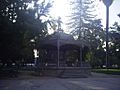
A garden pavilion in Plaza de Armas (Armas Square)
-
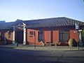
O'Higginian Historical Museum (Museo Histórico O'Higginiano)
-
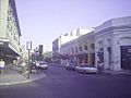
Calle Sur de Talca (Talca Southern Street)
-
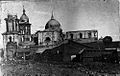
Damage at Talca Cathedral after the 1928 earthquake


See also
 In Spanish: Talca para niños
