Tay River facts for kids
Quick facts for kids Tay River |
|
|---|---|

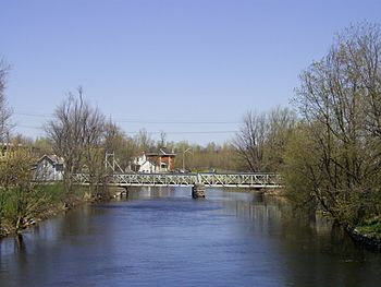
Tay River in Perth
|
|
|
Location of the mouth of the Tay River in southern Ontario
|
|
| Country | Canada |
| Province | Ontario |
| Region | Eastern Ontario |
| County | Lanark |
| Physical characteristics | |
| Main source | Bobs Lake Lanark Highlands 162 m (531 ft) 44°45′34″N 76°31′21″W / 44.75944°N 76.52250°W |
| River mouth | Lower Rideau Lake, Rideau River Port Elmsley 125 m (410 ft) 44°52′43″N 76°06′46″W / 44.87861°N 76.11278°W |
| Length | 95 km (59 mi) |
| Basin features | |
| Progression | Rideau River→ Ottawa River→ Saint Lawrence River→ Gulf of Saint Lawrence |
| River system | Ottawa River basin |
| Basin size | 850 km2 (330 sq mi) |
The Tay River is a cool river located in Lanark County in Eastern Ontario, Canada. It's part of a bigger water system that eventually flows into the Saint Lawrence River. The Tay River is a "left tributary" of the Rideau River, which means it flows into the Rideau River from its left side if you're looking downstream. The area of land that drains water into the Tay River is called its "watershed," and it's pretty big – over 800 square kilometers! It's one of six main water areas looked after by the Rideau Valley Conservation Authority.
Contents
Tay River's Journey
The Tay River starts its journey at Bobs Lake. A special gate called a "weir" controls how much water leaves the lake near a community called Bolingbroke. From there, the river flows northeast. It goes under Lanark County Road 36.
The river then reaches Christie Lake. After Christie Lake, it keeps heading northeast. It passes under Lanark County Road 6. At one point, the river splits into two parts. The right part is known as Scotts Snye. The Tay River then flows through the community of Glen Tay.
It continues its path to the town of Perth. In downtown Perth, the river actually splits into two main channels! But don't worry, they join back together by the time the river leaves Perth. The river then continues its flow until it reaches the Rideau River. From the Rideau River, the water eventually drains into the Ottawa River and then into the Saint Lawrence River.
The Tay River is about 95 kilometers (59 miles) long. It drains water from an area of about 850 square kilometers (328 square miles). There's also a special canal that connects the Tay River to the Tay Canal and Rideau Canal systems. This connection is at Beveridge Bay on Lower Rideau Lake.
Lakes Connected to the Tay River
The Tay River watershed is like a big bowl that collects water from many lakes. These lakes are important for the river's health and for people who live nearby. Here are some of the lakes in the Tay watershed:
Lakes at the Top of the Watershed
These lakes are located higher up in the watershed, generally above a old north-south railroad line.
- Abbott Lake
- Barton Lake
- Carnahan Lake
- Clow Lake
- Danby Lake
- Duncan Lake
- Eagle Lake
- Elbow Lake
- Leggat Lake
- Little Beaver Lake
- Little Mud Lake
- Long Lake
- Miller Lake
- Oconto Lake
- Scanlin Lake
- Spruce Lake
- Watson Lake
Lakes in the Middle Watershed Area
These lakes are found between the upper watershed and Christie Lake.
- Atwood Lake
- Beaver Lake
- Bobs & Crow Lake
- Buck Bay
- Burns Pond
- Christie Lake
- Crosby Lake
- Davern Lake
- Deer Lake
- Doran Lake
- Farrell Lake
- Green Bay
- Lake of the Hills
- Little Crosby Lake
- Little Rock Lake
- Little Silver Lake
- Little Twins Lake
- Lynn Lake
- Mud Bay
- O’Brien Lake
- Pike Lake
- Rainbow Lake
- Rock Lake (north)
- Sucker Lake
- Thompson Pond
- Victoria Lake
- Weatherhead Lake
Lakes Below Christie Lake
These lakes are located further downstream from Christie Lake.
- Andrew Lake
- Doctor McLaren Lake
- Mills Lake
- Mud Lake
- Otty Lake
- Rock Lake (south)
- Thoms Mud Lake
History of the Tay River
The Tay River was formed a very long time ago. This happened when the Champlain Sea dried up after the last ice age. The Mississauga First Nation people lived in this area first. They used the land around the river for hunting, especially in winter. They also likely gathered wild rice from lakes like Christie Lake. Sadly, the name they had for the river was not written down.
Early European settlers first called it the Pike River. But then, many Scottish settlers arrived after the Perth Military Settlement was founded in 1816. They likely named it the Tay River after the River Tay in Scotland. This new name became very popular by the 1820s. That's when many mills were built along the river. The Tay Canal was also built in the 1830s.
The mills on the Tay River and the Tay Canal were very important. They connected the area to the Rideau Canal system. This helped transport goods like lumber to Ottawa and other markets. Dams built on the upper Tay River created lakes, like Bobs Lake. These lakes acted as water storage for the Rideau Canal back then. Today, they are popular spots for cottagers and people who visit seasonally.
In 1998, different towns in Ontario joined together. The river gave its name to the new municipality called Tay Valley, Ontario. Even though the municipality doesn't cover the entire Tay River watershed, it's a nice way to honor the river!
 | Delilah Pierce |
 | Gordon Parks |
 | Augusta Savage |
 | Charles Ethan Porter |


