Te Kowai, Queensland facts for kids
Quick facts for kids Te KowaiQueensland |
|||||||||||||||
|---|---|---|---|---|---|---|---|---|---|---|---|---|---|---|---|
| Population | 227 (2021 census) | ||||||||||||||
| • Density | 13.67/km2 (35.4/sq mi) | ||||||||||||||
| Postcode(s) | 4740 | ||||||||||||||
| Elevation | 0–10 m (0–33 ft) | ||||||||||||||
| Area | 16.6 km2 (6.4 sq mi) | ||||||||||||||
| Time zone | AEST (UTC+10:00) | ||||||||||||||
| Location |
|
||||||||||||||
| LGA(s) | Mackay Region | ||||||||||||||
| State electorate(s) | Mirani | ||||||||||||||
| Federal Division(s) | Capricornia | ||||||||||||||
|
|||||||||||||||
|
|||||||||||||||
Te Kowai is a small, countryside area in Queensland, Australia. It is part of the Mackay Region. In 2021, about 227 people lived there.
Contents
Exploring Te Kowai's Location
Te Kowai is surrounded by natural features. The Pioneer River forms its northern border. The Mackay Ring Road runs along its north-east and eastern sides. Bakers Creek, a waterway, is found to the south-west and south.
The land in Te Kowai is mostly flat and low. It sits only 0 to 10 meters above sea level. This flat land is perfect for growing sugarcane. The Peak Downs Highway passes through Te Kowai. It enters from the east and leaves towards the west. There are also special train tracks called cane tramways. These tracks help transport the harvested sugarcane to sugar mills.
Te Kowai's Past: A Look Back
The name Te Kowai comes from an old railway station. This station was named after a nearby sugar plantation. The plantation itself was named after a New Zealand tree called kōwhai. The name was shortened, and the Māori word "Te" (meaning "the") was added.
Sugar Mill History
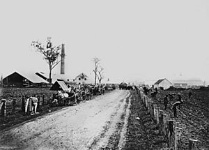
The Te Kowai sugar mill started operating in 1874. It was a busy place for about 20 years. In 1894, it joined with another mill called the Palms Mill. After that, the Te Kowai mill stopped working on its own.
Schools and Railways
Te Kowai State School opened its doors on November 13, 1883. It taught local children for many years. However, the school closed in December 1968.
A railway line was built in Te Kowai. It was part of the line connecting Mackay to Eton. Construction began in 1883 and finished in 1885. The Te Kowai railway station was located along this line. The railway line itself closed in 2009.
Community Life
The Te Kowai Presbyterian Church opened on December 8, 1918. It served as a place of worship for the community.
Who Lives in Te Kowai?
In 2016, the population of Te Kowai was 218 people. By 2021, the number of people living in Te Kowai had grown slightly to 227.
Learning Opportunities Near Te Kowai
There are no schools directly in Te Kowai. However, students can attend nearby schools.
- Primary Schools:
- Dundula State School in Bakers Creek
- Walkerston State School in Walkerston
- Mackay West State School in West Mackay
- Secondary School:
- Mackay State High School in South Mackay
Important Facilities in Te Kowai
Te Kowai is home to an important facility called the Mackay South Water Recycling Facility. It is also known as the Bakers Creek Water Treatment Plant. This plant cleans wastewater from about 63,000 people.
The plant produces high-quality recycled water. This water is used by farmers for irrigation. Using recycled water helps reduce the need to take water from underground sources. Any extra water that is not used for irrigation is safely released into Bakers Creek. This recycled water is good for crops because it contains nutrients. This is better for the environment than adding too many nutrients to the creek.
After the water is cleaned, some solid waste remains. This waste is spun very fast to remove any leftover water. The solid part is then sold as nutrient-rich compost. Farmers can use this compost to help their crops grow.
Te Kowai Weather Station
Te Kowai has a weather station. It is run by the Bureau of Meteorology. This station collects important weather information. However, it does not operate on weekends or public holidays.
| Month | Jan | Feb | Mar | Apr | May | Jun | Jul | Aug | Sep | Oct | Nov | Dec | Year |
|---|---|---|---|---|---|---|---|---|---|---|---|---|---|
| Average max. temperature °C |
30.9 | 30.4 | 29.5 | 27.9 | 25.7 | 23.7 | 23.4 | 24.6 | 26.8 | 29.0 | 30.3 | 31.3 | 27.8 |
| Average min. temperature °C |
21.9 | 21.9 | 20.7 | 18.1 | 14.7 | 11.6 | 10.1 | 10.8 | 13.4 | 16.6 | 19.2 | 20.8 | 16.6 |
| Rainfall mm |
341.3 | 346.5 | 277.5 | 144.3 | 92.3 | 61.3 | 36.0 | 30.0 | 28.2 | 45.6 | 83.2 | 180.0 | 1666.8 |
| Source: Bureau of Meteorology | |||||||||||||
 | Selma Burke |
 | Pauline Powell Burns |
 | Frederick J. Brown |
 | Robert Blackburn |


