
Telegraph Avenue facts for kids

The northern end of Telegraph Avenue in Berkeley.
|
|
| Length | 4.5 mi (7.2 km) |
|---|---|
| Location | Berkeley and Oakland, California |
| South end | Broadway in Downtown Oakland |
| Major junctions |
|
| North end | Bancroft Way at the southern edge of UC Berkeley |
Telegraph Avenue is a famous street in California. It starts in Downtown Oakland and stretches north to the University of California, Berkeley campus in Berkeley, California. The street is about 4.5 miles (7 km) long.
Many people, especially students from the University of California, think of "Telegraph" as a special four-block area. This section is just south of the university, from Bancroft Way to Dwight Way. It's a busy center for campus and community life. You can find many restaurants, bookstores, and clothing shops here. Street vendors also set up along the wide sidewalks. This part of Telegraph Avenue attracts all kinds of people. You might see college students, tourists, artists, and many others enjoying the lively atmosphere.
Contents
How Telegraph Avenue Got Its Name

Telegraph Avenue wasn't always called that. It was once made up of several different roads.
In 1859, a telegraph line was built between Oakland and Martinez. The roads next to this line were then named "Telegraph Road." The part of Telegraph Road from downtown Oakland to the Temescal area was first known as "Peralta Road." Another part, going up to what is now Claremont Canyon, was called "Harwood's Road." This was named after William Harwood, an early politician in Oakland.
The original Telegraph Road followed the path of today's Telegraph Avenue through Oakland. Then, it continued along what is now Claremont Avenue. It went all the way up to the top of the Berkeley Hills.
Street Names in Berkeley
In Berkeley, the people who started the private College of California (which later became the University of California) planned a neighborhood south of their new campus. They did this to help pay for building the university. The streets were named in alphabetical order from east to west. The third street was named "Choate Street."
Later, Oakland extended a road to connect with Berkeley's Choate Street. But Oakland named its part "Humboldt Avenue."
Early Transportation and Growth
Oakland's first horsecar line was built in 1869. It ran along Telegraph Road. This line was extended over time, reaching the university campus in 1873. A business area quickly grew along Choate Street. The horsecar line was later replaced by a steam-powered train, and then by an electric streetcar. This new transportation helped neighborhoods grow all along the route. It even led to the creation of an amusement park called Idora Park.
Changing Names to Telegraph
Eventually, the part of Telegraph Road going up to Harwood's Canyon was renamed "Claremont." This was done to help a developer in that area. Because of this, the cities of Berkeley and Oakland decided to change Humboldt and Choate streets to "Telegraph." This made sense because Oakland's part of the road already lined up with the old Telegraph Road. The city of Berkeley officially made this change on October 10, 1892.
The very last part of the old Telegraph Road, which went up the canyon to the Berkeley Hills, was renamed Claremont Road. This happened in 1913, after the owners of the Claremont Hotel & Spa asked for the change.
Telegraph Avenue in the 20th Century

In 1910, Sather Gate was built at the northern end of Telegraph Avenue. This gate is a famous entrance to the university. In the 1940s, the university built Sproul Hall on Telegraph. In the 1950s, the campus grew south to Bancroft Way. This meant Telegraph Avenue became shorter by about one and a half blocks. Buildings were taken down to make room for Sproul Plaza and new university buildings, including the student union.
A Place for Public Gatherings
The Berkeley end of Telegraph Avenue, along with Sproul Plaza, has been a site for many important public gatherings and protests since the 1960s. In 1969, Telegraph was the scene of a big event during the conflict over People's Park. People gathered to express their views.
The 1960s also saw the building of the Grove Shafter Freeway. This freeway runs parallel to Telegraph Avenue, just half a block west. It created a barrier between Telegraph Avenue and what is now Martin Luther King Jr. Way. It also divided the Temescal District.
Telegraph Avenue Today
The events of the 1960s and 1970s made Telegraph Avenue, and Berkeley, known as a symbol of counterculture. Over the next few decades, the Berkeley end of Telegraph became a place where many homeless people and panhandlers gathered. By the 1990s, it was a destination for young people who had left home from all over the United States. The number of panhandlers has gone down since the late 1990s. University students are still the largest group of people on Telegraph. The street continues to be a main spot for food, culture, and student life near the campus.
Diverse Neighborhoods
More recently, a Korean business area has grown just south of Temescal along Telegraph Avenue. There have been talks about calling this area "Koreatown." However, this has caused some discussion because most people living nearby are not Korean or Korean-American. A large Ethiopian and Eritrean community has also led to many Ethiopian restaurants, cafes, and social clubs. These stretch along Telegraph from about 30th Street in Oakland all the way into Berkeley.
Future of the Street
Because many people walk on Telegraph Avenue and the street is narrow, the area near the Berkeley campus is a one-way street for cars. There have been discussions about completely stopping car access, which is still a big topic in the city council. A plan by AC Transit to build a Bus rapid transit line on Telegraph has also caused debate. Some worry it might remove parking or stop car access, especially at the northern end.
Images for kids
-
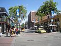
The northern end of Telegraph Avenue in Berkeley.
-
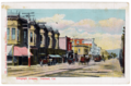
Looking north on Telegraph from Downtown around the turn of the century.
-
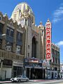
The Fox Theatre is located on the southern end of Telegraph Avenue, in Downtown Oakland.
