Terrey Hills facts for kids
Quick facts for kids Terrey HillsSydney, New South Wales |
|||||||||||||||
|---|---|---|---|---|---|---|---|---|---|---|---|---|---|---|---|
.jpg)
Suburban street
|
|||||||||||||||
| Population | 3,041 (2016 census) | ||||||||||||||
| Postcode(s) | 2084 | ||||||||||||||
| Elevation | 194 m (636 ft) | ||||||||||||||
| Location | 25 km (16 mi) north of Sydney CBD | ||||||||||||||
| LGA(s) | Northern Beaches Council | ||||||||||||||
| State electorate(s) | Pittwater | ||||||||||||||
| Federal Division(s) | Mackellar | ||||||||||||||
|
|||||||||||||||
|
|||||||||||||||
Terrey Hills is a suburb in Northern Sydney, New South Wales, Australia. It is about 25 kilometres north of the main city centre of Sydney. Terrey Hills is part of the Northern Beaches Council area.
This suburb is very green and has many trees. Some parts even feel like the countryside. Many people in Terrey Hills keep their horses here. The name "Terrey Hills" comes from two early landowners, Samuel Hills and Obediah James Terrey. Obediah Terrey bought 640 acres (about 2.6 square kilometres) in 1881. Samuel Hills owned 100 acres (about 0.4 square kilometres) nearby.
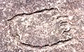
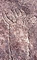
Long before Europeans arrived, Indigenous people lived in this area. You can still find rock carvings in some places. One group of carvings near Larool Road shows hunting scenes. These carvings include kangaroos, people, and footprints. The Terrey Hills Post Office first opened on 17 June 1935.
Contents
History of Terrey Hills
Terrey Hills is famous for its "laterite" rock. Laterite is a special type of rock that forms in hot, wet climates. It can tell us about how the climate has changed over a very long time. The laterite from Terrey Hills was used to build early roads. It was also used to protect the coast at Collaroy Beach from the ocean.
Terrey Hills is the only place in New South Wales where tiny plant fossils have been found in laterite. The main laterite quarry (now a playing field) and a smaller one at Tumbledown Dick are important historical sites. They are protected by heritage listings.
There has been an effort to protect the laterite at Tumbledown Dick. This area is affected by plans to widen Mona Vale Road. The laterite was dug out during the Great Depression. This was a time in the 1930s when many people in Australia could not find work. The quarry in Terrey Hills was a key place for government relief work. This work helped people earn some money.
Gai Halstead wrote a book in 1988 called "The story of Terry Hills and Duffys Forest." It was supported by Dick Smith's "Australian Geographical" group, which was based in Terrey Hills. The book explains that married men worked at the quarry for two weeks on and one week off. Single men worked one week on and two weeks off.
There was not much other work available then, and many people in Terrey Hills were poor. For a week of digging laterite with a pick and shovel, workers earned £1. They had to walk to Narrabeen to get paid. Besides digging laterite, these workers also built or improved roads. They worked on roads from Terrey Hills to Mona Vale, Cottage Point, and Coal and Candle Creek.
Climate and Weather
Terrey Hills has mild temperatures. This is because it is high up, close to the ocean, and has many trees. It has warm summers and cool winters. The weather station here records some of the mildest temperatures in the greater Sydney area.
| Climate data for Terrey Hills | |||||||||||||
|---|---|---|---|---|---|---|---|---|---|---|---|---|---|
| Month | Jan | Feb | Mar | Apr | May | Jun | Jul | Aug | Sep | Oct | Nov | Dec | Year |
| Record high °C (°F) | 43.9 (111.0) |
40.3 (104.5) |
35.6 (96.1) |
32.2 (90.0) |
27.2 (81.0) |
21.9 (71.4) |
23.6 (74.5) |
27.9 (82.2) |
32.7 (90.9) |
36.3 (97.3) |
39.5 (103.1) |
40.3 (104.5) |
43.9 (111.0) |
| Mean daily maximum °C (°F) | 26.7 (80.1) |
26.0 (78.8) |
24.7 (76.5) |
22.1 (71.8) |
19.5 (67.1) |
16.4 (61.5) |
16.1 (61.0) |
17.8 (64.0) |
20.8 (69.4) |
22.8 (73.0) |
24.0 (75.2) |
25.3 (77.5) |
21.9 (71.4) |
| Mean daily minimum °C (°F) | 18.4 (65.1) |
18.2 (64.8) |
16.9 (62.4) |
13.8 (56.8) |
10.7 (51.3) |
8.9 (48.0) |
7.6 (45.7) |
8.4 (47.1) |
11.2 (52.2) |
13.2 (55.8) |
15.3 (59.5) |
16.6 (61.9) |
13.3 (55.9) |
| Record low °C (°F) | 11.9 (53.4) |
11.6 (52.9) |
10.4 (50.7) |
5.5 (41.9) |
4.3 (39.7) |
0.9 (33.6) |
0.2 (32.4) |
1.5 (34.7) |
4.2 (39.6) |
6.0 (42.8) |
5.8 (42.4) |
9.3 (48.7) |
0.2 (32.4) |
| Average precipitation mm (inches) | 99.7 (3.93) |
123.9 (4.88) |
118.7 (4.67) |
134.5 (5.30) |
52.4 (2.06) |
148.4 (5.84) |
63.5 (2.50) |
57.8 (2.28) |
62.6 (2.46) |
70.8 (2.79) |
108.1 (4.26) |
82.6 (3.25) |
1,107.7 (43.61) |
| Average precipitation days | 13.7 | 13.8 | 13.3 | 13.5 | 7.9 | 13.8 | 10.9 | 9.1 | 9.5 | 10.8 | 12.9 | 11.5 | 140.7 |
| Source 1: (averages, records and rain days) | |||||||||||||
| Source 2: (rainfall amount) | |||||||||||||
Shops and Services
Terrey Hills has a shopping centre. It includes a Friendly Grocer supermarket and an Post Office. There are also other shops, restaurants, and places that sell plants and landscaping supplies.
The Northern Beaches Council has its Volunteer Services Centre in Thompson Drive. Terrey Hills is home to several important emergency services. These include the Rural Fire Service (RFS) and the State Emergency Service (SES). The Marine Rescue NSW used to be here but has moved nearby to Belrose.
You can also find the Citizens Radio Emergency Services Team (CREST) and the Wireless Institute Civil Emergency Network (WICEN) here. These groups help with communication during emergencies. The local Rural Fire Station is on Yulong Avenue. This volunteer team fights both bush fires and building fires. They have special fire trucks for different types of fires.
Terrey Hills is also where the Manly-Warringah Media Co-Operative is located. The Radio Northern Beaches radio stations moved here in 2013. The NSW Government’s Bureau of Meteorology also has its weather radar for the Sydney Region here. It is near the intersection of Mona Vale Road and Forest Way.
Getting Around Terrey Hills
Terrey Hills has good bus services. A CDC NSW bus depot is also located here. Buses can take you to many places. You can go to the Sydney city centre, Chatswood, Gordon, Macquarie Park, North Sydney, Mona Vale, and Manly. There are also special buses for events at Sydney Olympic Park. The buses to Chatswood and Gordon stop at train stations, so you can easily catch a train.
Mona Vale Road is the main road through Terrey Hills. It connects the suburb to the rest of the Northern Beaches to the east. It also links to suburbs like Chatswood, Hornsby, and North Ryde to the south and west.
Schools in Terrey Hills
Terrey Hills has six schools:
- Northern Beaches Christian School
- The Sydney Japanese School
- Terrey Hills Public School
- Kinma School
- German International School Sydney
Sports and Fun Activities
Terrey Hills offers many sports and recreation options. There are two golf courses and two tennis centres with many courts. You can also find several BMX tracks where races and competitions are held. A skatepark opened in Terrey Oval in 2018.
The Manly-Warringah Radio Society (VK2MB) is a local club for people interested in Amateur Radio. They meet every Wednesday evening at the Terrey Hills Girl Guides hall.
The Terrey Hills Wolves are the local Rugby Union Club. They play their games at their home ground, Yulong Oval. The local soccer team is called The Belrose Terrey Hills Raiders.
Images for kids
-
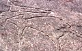
This image and following: Aboriginal rock carvings, Larool Road
-
-