Texico, New Mexico facts for kids
Quick facts for kids
Texico, New Mexico
|
|
|---|---|

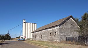
Grain elevator in New Mexico, wooden building in Texas
|
|

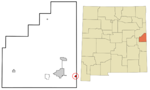
Location of Texico, New Mexico
|
|
| Country | United States |
| State | New Mexico |
| County | Curry |
| Area | |
| • Total | 0.83 sq mi (2.14 km2) |
| • Land | 0.83 sq mi (2.14 km2) |
| • Water | 0.00 sq mi (0.00 km2) |
| Elevation | 4,144 ft (1,263 m) |
| Population
(2020)
|
|
| • Total | 956 |
| • Density | 1,155.99/sq mi (446.31/km2) |
| Time zone | UTC-7 (Mountain (MST)) |
| • Summer (DST) | UTC-6 (MDT) |
| ZIP code |
88135
|
| Area code(s) | 575 |
| FIPS code | 35-77250 |
| GNIS feature ID | 2412057 |
Texico is a small city in Curry County, New Mexico, United States. It's special because it sits right on the border between Texas and New Mexico. In 2020, about 956 people lived there. Right across the border from Texico is the town of Farwell, Texas.
Contents
A Look Back
Texico got its name by combining "Texas" and "New Mexico." It's a portmanteau, which means it's a new word made by blending parts of two other words. The city is located right on the border between the two states.
A famous breakaway roper named Ronda Ragland lives in Texico.
In 2023, a big project started to bring clean drinking water to Texico and nearby towns. This project is called the FW1 Ute Reservoir pipeline. It will provide water to places like Cannon Air Force Base, Clovis, Portales, Elida, and Texico by 2030.
About the Area
Texico is located on the high plains of Eastern New Mexico. This area is known as the Llano Estacado. The city covers about 0.8 square miles (2.14 square kilometers) of land.
Weather in Texico
Texico has a semiarid climate. This means it's usually dry, but it gets some rain.
| Climate data for Texico, New Mexico | |||||||||||||
|---|---|---|---|---|---|---|---|---|---|---|---|---|---|
| Month | Jan | Feb | Mar | Apr | May | Jun | Jul | Aug | Sep | Oct | Nov | Dec | Year |
| Mean daily maximum °C (°F) | 12 (53) |
14 (57) |
18 (65) |
23 (73) |
27 (81) |
32 (90) |
33 (91) |
32 (89) |
28 (83) |
23 (74) |
16 (61) |
12 (53) |
23 (73) |
| Mean daily minimum °C (°F) | −5 (23) |
−3 (26) |
−1 (31) |
4 (39) |
9 (48) |
14 (57) |
17 (62) |
16 (60) |
12 (53) |
6 (43) |
−1 (31) |
−4 (24) |
5 (41) |
| Average precipitation mm (inches) | 10 (0.4) |
10 (0.4) |
20 (0.8) |
20 (0.8) |
51 (2) |
61 (2.4) |
71 (2.8) |
79 (3.1) |
46 (1.8) |
43 (1.7) |
13 (0.5) |
13 (0.5) |
430 (17.1) |
| Source: Weatherbase | |||||||||||||
Who Lives in Texico
| Historical population | |||
|---|---|---|---|
| Census | Pop. | %± | |
| 1910 | 409 | — | |
| 1920 | 381 | −6.8% | |
| 1930 | 569 | 49.3% | |
| 1940 | 478 | −16.0% | |
| 1950 | 691 | 44.6% | |
| 1960 | 889 | 28.7% | |
| 1970 | 772 | −13.2% | |
| 1980 | 958 | 24.1% | |
| 1990 | 966 | 0.8% | |
| 2000 | 1,065 | 10.2% | |
| 2010 | 1,130 | 6.1% | |
| 2020 | 956 | −15.4% | |
| U.S. Decennial Census | |||
According to the census from 2000, 1,065 people lived in Texico. There were 381 households and 278 families. The city had about 1,299 people per square mile.
About 37.3% of households had children under 18 living with them. Most households (55.4%) were married couples. The average household had 2.80 people.
The age of people in the city varied. About 30.8% were under 18 years old. About 12.8% were 65 years or older. The average age was 34 years.
Schools in Texico
Texico is part of the Texico Municipal Schools school district.
See also
 In Spanish: Texico para niños


